 Mark Twain wasn’t far wrong with this sardonic, perceptive quip. If he was able to comment on the global water situation today, he might add “I guess so, I dunno“.
This is the first in a series of posts on underground water, or groundwater. The posts will outline, with a non-specialist perspective, the science of aquifers, groundwater movement, how groundwater interacts with surface water, water extraction-pumping, and contamination.
For the oil and gas industry, groundwater and aquifers are becoming increasingly important. Many jurisdictions now require protection and monitoring of shallow aquifers during drilling, production and eventual decommissioning. Oil shale fracking and coal-bed methane require huge amounts of water to drive the hydrocarbons out of the reservoirs; this water then needs to be disposed or reused. Groundwater extraction has definite limits depending on the nature and extent of an aquifer; those limits need to be understood to ensure there is a balance among extraction for all users and natural aquifer recharge.
Geofluids in general
Groundwater is a Geofluid. Geofluids are an integral part of all processes that take place in or on the earth’s crust:
- Fluids include fresh and saline water (aqueous fluids) and hydrocarbons (oil and gas),
- Depth of flow ranges from the shallowest to deepest parts of the crust.
- Rates of fluid flow rates range from cm/second near the surface, to cm/million years deep in the crust,
- Aqueous fluids are involved in all chemical reactions and distribute dissolved mass through the crust, including those that form rocks and (organic) hydrocarbons,
- Fluids play an important role in how the earth deforms, such as deep and shallow fracturing-earthquakes,
- Without fluids there would be no groundwater, mineral deposits or hydrocarbons.
Water is a strategic asset
At the time of writing (August, 2016), Havelock North, a town in New Zealand with a population of about 14,000, was recovering from a contaminated water incident that made 4500 people very sick; the offending bug was campylobacter, a rather nasty bacterium. The source of the contamination has not yet been determined. However, the incident is a reminder of how precarious water supply can be and where a lack of care and attention to quality, over and above any external environmental conditions, can have disastrous consequences.
Conflicts over water have innumerable historical precedents; whether between neighbours vigorously discussing their local water rights, or nations going to battle. We have been reminded time and again by various leaders, UN Secretary Generals and so on about the strategic value of water. Indeed, a nation’s prosperity is linked, perhaps more than anything else, to an adequate supply of clean water. And yet in many, if not most countries there is a staggering litany of disasters where water quality and/or quantity have been compromised, borne from a lack of scientific knowledge, wilful neglect, an absence of political will, international belligerence, or all four. I was living in Budapest in 1992 when a politically and scientifically contested diversion of the Danube resulted in an almost overnight fall in river levels in Hungary, stranded barges, and dry water wells on the adjacent flood plain – consequences that were predicted.
In keeping with this general introductory theme, I have listed a few examples of surface and groundwater problems that have national, international and strategic ramifications. They are all interesting because they impinge on security of supply, economics, health, industry, agriculture, ecosystems, the environment and the potential for conflict.
USA – California The prolonged drought in this region won’t be news to anyone. Lake Mead, the largest reservoir that provides water to California, Nevada and Arizona has shrunk to 37% of capacity. Drought means increased dependency on groundwater but one of the main resource areas, the Central Valley is already over-utilized. Deeper aquifers beneath Central Valley at an average of 3000m have been touted as potential future resources, but this would be an expensive proposition; most of this water would also require some degree of desalination.
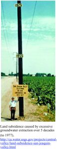
Excessive and prolonged groundwater extraction from parts of Central Valley have resulted in severe land subsidence (groundwater mining will be illustrated in a future post). The now classic image (top of post), taken in 1977 level shows levels of subsidence in San Joaquin Valley over five decades.
High Plains region; The Ogallala Aquifer, the most important shallow aquifer in this region, serves about 27% of the irrigated land in the United States – hence it’s importance. However, excessive pumping since about 1950 in many areas has significantly lowered the watertable, to the extent that deeper wells are now required. The problems of supply are exacerbated by recharge rates that over most of the aquifer exceed 6000 years.
Chicago-Milwaukee area
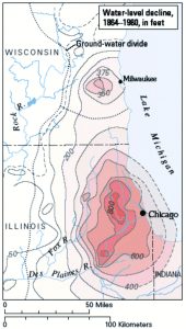 Water supply to Chicago is mostly from groundwater. The unintended consequence of about 150 years of pumping has lowered well water levels by up to 275m, despite the proximity to Lake Michigan. The water level map opposite shows how the declines are centred around Chicago and Milwaukee.
China China has about 22% of the world’s population but only about 5-6% of its freshwater, and much of this is seriously compromised by pollution or overuse. Rapid depletion of groundwater and falling watertables is particularly evident in drier regions like the North China Plain. Groundwater supplies about 400 cities in China and 60% report moderate to significant contamination. Groundwater pollution from industrial and agricultural practices is widespread; many cities have been forced to look at deeper aquifers for continued supply. Arsenic is a serious problem in some provinces.
Groundwater extraction commonly exceeds aquifer capacity. Saline intrusion into coastal aquifers, and land subsidence are common. Subsidence in parts of Beijing for example are as high as 10cm/year. This has huge technical and economic implications for city infrastructure.
Australia Bore pressures across the The Great Artesian Basin aquifer are declining because of a combination of extraction (pumping) and reduced recharge. This is one of the largest aquifer systems in the world, extending over 22% of the land mass. Some of this water is very old – up to 2 million years, which in practical terms effectively means no recharge.
Middle East Nine out of 14 Middle East countries have serious water shortages; most rely on groundwater extraction.
Israel obtains 40-50% of its supply from groundwater beneath the West Bank, where there have been significant declines in watertables. About 50% of Israel’s surface and groundwater is sourced from countries outside its border. Golan Heights, a military strategic position, also guards the confluence of the Dan, Banias and Hasbani rivers with Jordan River; the drainage basin incorporates Lebanon, Israel, Jordan, Syria and West Bank. Water quality has deteriorated significantly because of increased discharge of untreated sewerage and diversion of various waterway. Flow to the Dead Sea has declined mainly because of water abstraction by Jordan, Syria and Israel, to the extent that the lake level has fallen about 40m since the 1950s.
Lake Chad Straddling the borders of Chad, Niger and Cameroon (west Africa) the lake has shrunk from about 25,000 km2 to barely 1000 km2 because of agricultural practices and changing climate.
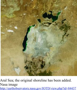
Aral Sea Likewise, the Aral Sea in central Asia (straddling Uzbekistan and Kazakhstan) has all but disappeared because of agricultural withdrawal. One consequence of this is that the salinity has increased.
