The value of missing time
Geological time that has gone missing
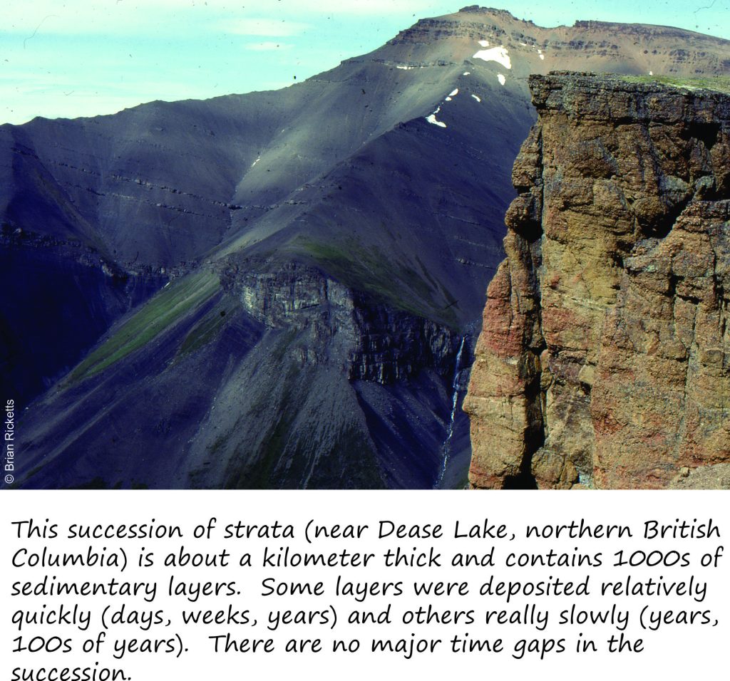
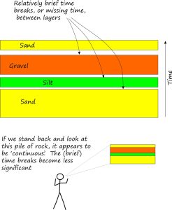
When you next look at sedimentary strata exposed in a hillside, cliff or road-cut, don’t just think of it as a pile of rock but as an expression of time; the length of time it took to deposit all that sediment. The mountain exposure in the accompanying image is a great example. Here, thousands of sedimentary layers, or strata accumulated one at a time, one upon the other. Geologists tend to think of a succession like this as representing relatively continuous deposition of sediment, not necessarily uniform, but certainly continuous. However, we also recognize that between each stratum there is probably some missing time that represents the amount of time taken to change from one set of environmental conditions to another. For example, one layer may have been deposited as beach sand and the overlying layer in an estuary or tidal channel. The length of time that is missing may be minutes, weeks, 100s or even 1000s of years that, from a geological perspective are like the blink of an eye.
 What do we mean exactly by ‘missing time’? Again from a geological perspective it represents a period in which no sediment was deposited. There may well have been things going on during this period of time, but their record is either partly or completely missing. Geologists don’t deny that there are lots of brief (relatively speaking) time gaps in our succession of strata, in fact they make use of them wherever possible.
What if there were major interruptions?
This is where James Hutton, one of geology’s founding thinkers comes in. As noted in an earlier post, Hutton understood the immensity of geological time; for him there was “… no vestige of a beginning, no prospect of an end”.
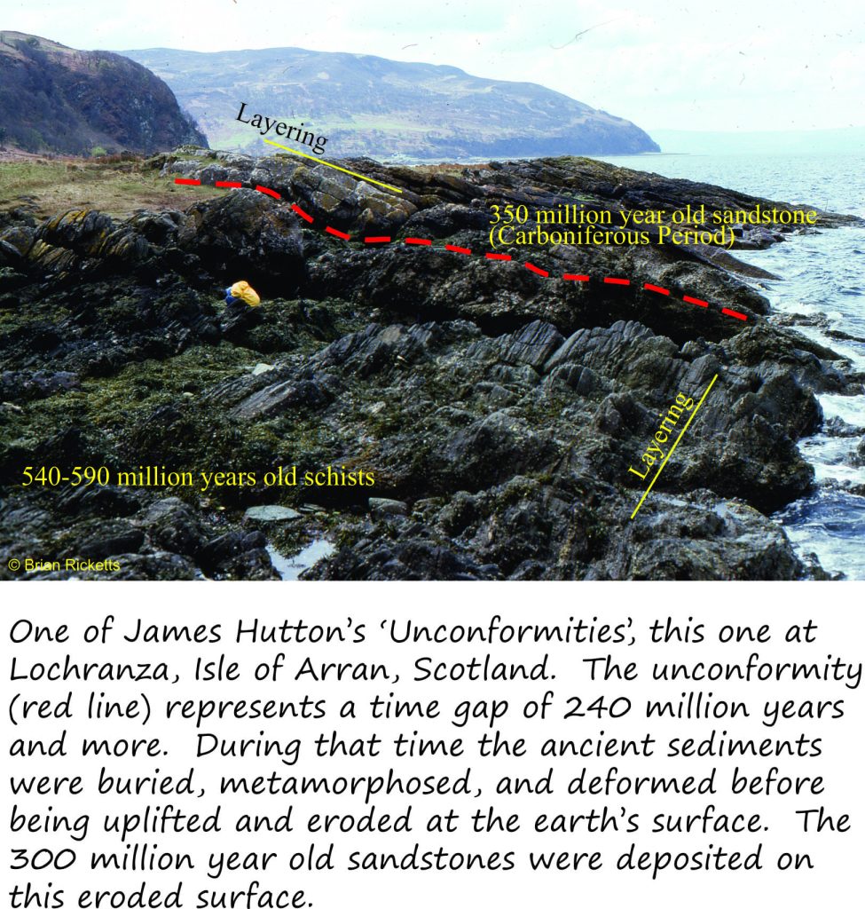
Hutton’s ideas about time were developed by observing natural processes of erosion, how rocks break down to sediment and how this sediment is deposited. Importantly, Hutton also observed old sedimentary rocks and it was his discoveries in Scotland in the 1770s-80s that eventually led him to announce his theory of the earth in 1785. Hutton had discovered unconformities, or missing time.
Geologists have since identified 1000s of unconformities. The kind of unconformity recognized by Hutton is now called an angular unconformity because of the discordance in orientation between the two sets of strata. Angular unconformities commonly represent a protracted period of missing time, anything from a few million years to several hundred million years. Major unconformities, like Hutton’s, can often be traced across continents. They play an important role in the reconstruction of where ancient continents used to be (i.e. plate tectonics).
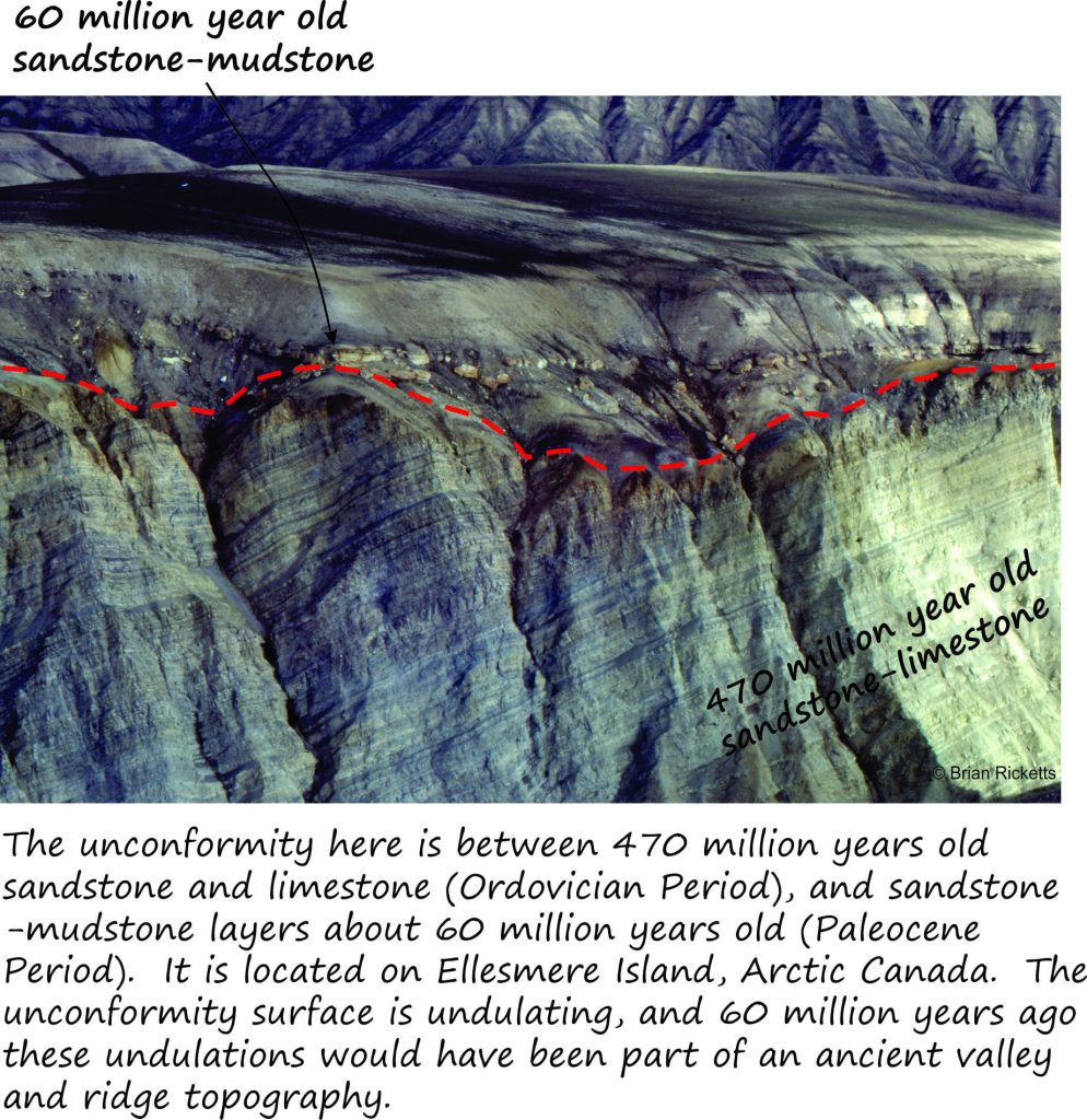
When we encounter unconformities in our studies we do not throw up our hands in frustration. Geologists can in fact gain huge insights into events and processes that produced this arrangement of strata. In our two examples (Lochranza and Ellesmere Island) we can decipher some of the events:
- The older sediment was deposited over a long period of time. Fossils and radiometric dating will tell us how old these deposits are.
- The sedimentary strata were buried and hardened.
- The strata were tilted, folded and fractured (faulted), then uplifted. These are mountain-building processes that can affect large parts of continents (or continental plates using the jargon for plate tectonics).
- Uplift eventually brought the deformed strata to the surface where they were eroded, scoured and generally subjected to the elements of weather. These events at the earth’s surface resulted in the unconformity upon which younger sediment was then deposited.
- We can (hopefully) date the younger strata using the same methods employed for the older strata. Note that the younger strata now lie across tilted older strata.
At Lochranza the unconformity represents about 240 million missing years. The Ellesmere Island example represents an even longer period of missing time; about 410 million years.
Not all unconformities are angular like our two examples. Significant unconformities can also occur between sets of parallel strata; this category is commonly called a disconformity. This kind of time gap can sometimes be a bit tricky to identify especially if the kinds of sediment above and below the surface are similar. This is where fossils and radiometric dating frequently come to the rescue.
Unconformities are important despite the fact that something is missing. If we can trace an unconformity across large distances, across continents, then we can also infer that the cause of the missing time is related in some way. Unconformities help us to correlate major events from one place to another. This in turn helps us develop the geological history on the scale of entire continents or tectonic plates
Missing time is common in the piles of rock and strata upon which we live. Even the point of contact between a layer of topsoil that covers some local bedrock may be an unconformity or disconformity. So if you are fortunate enough to see something like this, try to imagine how much time might be missing and what processes and events might have transpired between the formation of the soil above and the rock below the unconformity.


