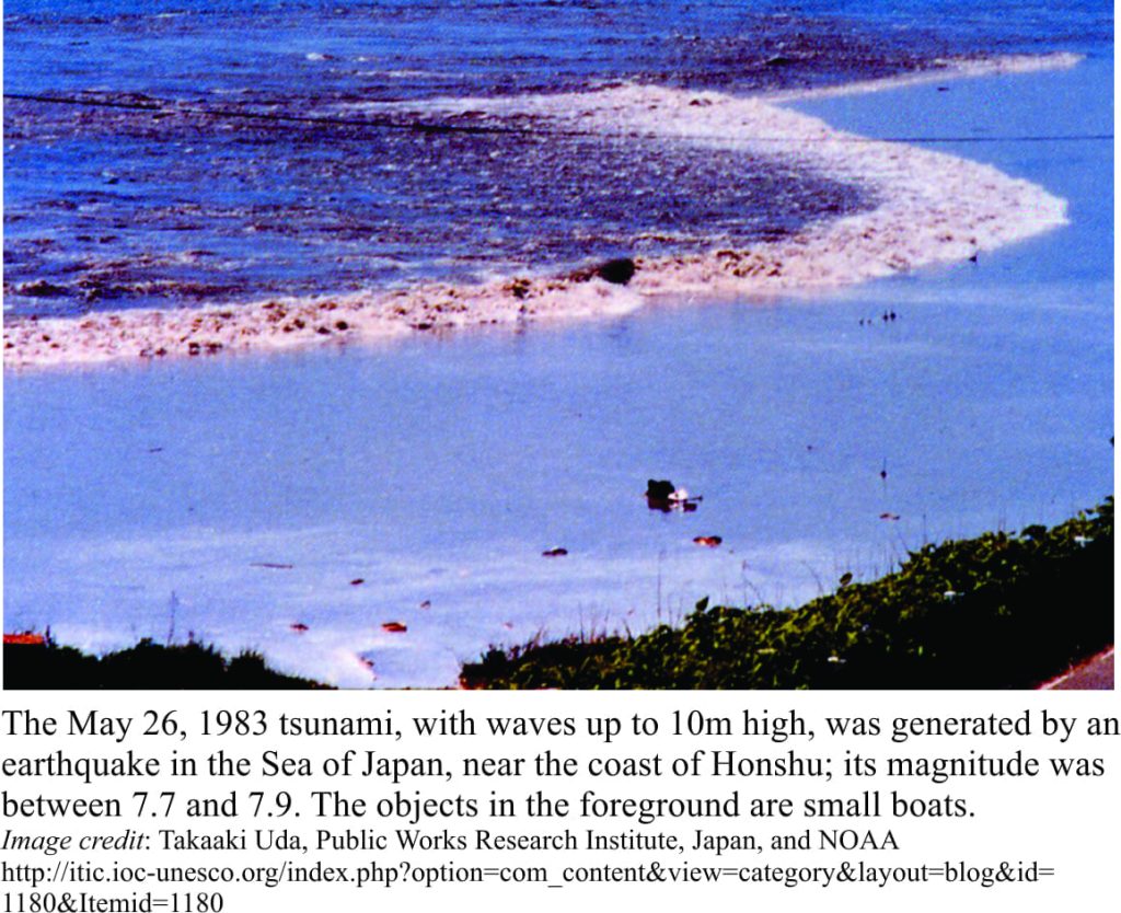
Tsunami statistics make grim reading, which is why I am not going to quote any. There are some great documentaries and websites that will regale you with all the stats you need. There’s even a couple of movies, where, if you sift through the hype, you may see a smidgen of science, or hear a bit of terminology added to the dialogue to give the impression of knowledgeable heroes.
The word Tsunami derives from two Japanese words; Tsu meaning harbour, and nami wave; an appropriate etymology given that these forces of nature really come into their own along shallow coasts and harbours. About 80% of tsunamis are generated by powerful earthquakes (particularly those beneath the sea floor); the remaining 20% result from large landslides, volcanic eruptions, and less frequently (fortunately) meteorite impacts. They are sometimes referred to, incorrectly, as tidal waves. Tides result from astronomical forces. We can think of the succession of high and low tides as the passing of a wave that has a period of about 12 hours (the time from one high tide to the next). Tidal waves move along coasts such that a high tide at one location (i.e. the crest of the wave) will occur at a different time to that at a more distant location. Tides also move water masses; waves do not.
Sea and lake surface waves are generated by wind. The wind provides the energy which is transferred to surface waters. As a general rule, the stronger the wind, the greater are wave amplitude, wavelength, and speed. Surface waves are basically pulses of energy. As such , a water mass does not move in concert with the wave. Instead, water particles beneath waves have a circular or elliptical motion (referred to as orbitals); the larger orbitals occurring immediately below the crest, decreasing in size to a depth that equates to about half the wavelength. This means that in deep water, waves do not interact with the sea floor. This kind of surface wave is given the name deep-water wave, the speed of which depends only on the ratio of wavelength to wave period. Deep-water waves occur where water depth is greater than half the wavelength.
As waves approach the coast, the wave orbitals begin to touch the sea floor (also referred to as wave-base) and wave speed decreases. At these depths (depth is less than half the wavelength), loose sediment can be moved by the wave orbitals. Some energy is transferred to the sea floor, but to conserve energy, the height, or wave amplitude must also increase. As you can see in the diagram, the orbitals also become flattened. At this stage, the waves have become shallow-water waves.
Although it may seem counterintuitive, tsunamis behave as shallow-water waves. They have long wavelengths, commonly measured in 10s to 100s of kilometres. The speed of shallow-water waves, including tsunamis, is independent of their wavelength, but is dependent on water depth in the following way:
Speed = √(g . depth) (g = gravitational constant, 9.8m/s2; depth in metres)
In the case of tsunamis, the wavelength is many times greater than water depth, even in oceans more than 4000m deep. For example, a tsunami traveling across ocean that is 4000m deep will have a speed of 198m/second, or 713 km/hour. This animation of the 2010, M8.8 Chile earthquake and tsunami gives an impression of the speed of wave propagation across oceans, and the shape of the wave fronts. Tsunami waves commonly pass unnoticed beneath ships at sea or offshore rigs. As they approach shallower water, their speed decreases to between 40-80km/hour (because speed is dependent on water depth), but the amount of energy in the wave changes very little; to compensate, the wave amplitude must increase. Earthquakes that generate tsunamis create several waves that spread out from the epicentre. All these waves can be destructive, and in some cases the first wave is the least harmful. It is also possible for a wave trough to reach the coast before the first wave crest; this results in a rapid drawdown of the water-level, exposing parts of the foreshore that would not normally be seen at even the lowest tides. Unfortunately, in all too short a time, the absence of water is replaced by a more menacing prospect.
Landslides can also produce monster waves; Lituya Bay in Alaska, 1958 is a good example with first-hand witnesses to the 15-22m wave. A prime example of volcanic eruption-derived waves is the cataclysmic 1883 Krakatoa eruption; a 30m tsunami wreaked havoc in Indonesia and across Sunda Strait.
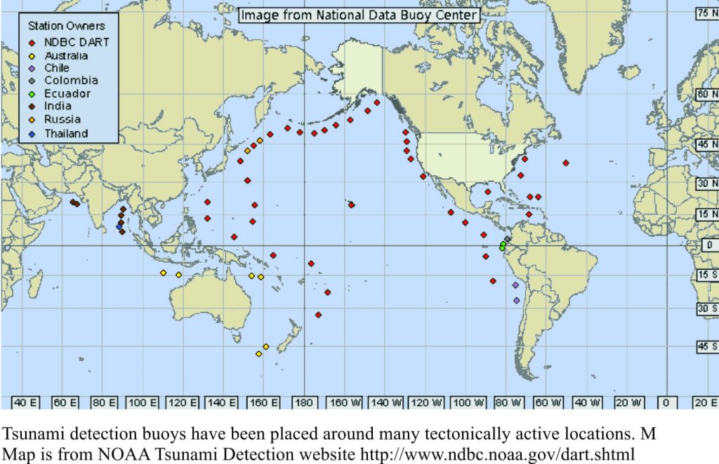
Tsunami warning systems generally involve an international effort to, in the first instance, detect and pinpoint the epicentre of large earthquakes, and secondly, to detect tsunamis and predict their arrival times at different locations. There is a particular focus on submarine and near-coast, shallow crust seismic events of magnitude 7 and greater; high magnitude earthquakes deeper than about 100km generally do not produce destructive tsunamis. Tsunami detection buoys have been installed in 59 deep ocean locations, most around the Pacific rim. The map shows the buoys to be located along tectonically active plate margins, such as the west coasts of North and South America, the Aleutian Arc, and other volcanic arcs – subduction zones from Japan through to New Zealand.
The deep-water buoys are anchored to the sea floor; for each sea-bottom buoy there is a linked surface buoy that relays data via satellite. The deep buoys measure subtle changes in water pressure that can be used to calculate changes in sea-surface height. The latest models have two-way communications so that a particular buoy can be programmed to search for pressure changes if an earthquake is known to have occurred. Of course, all this is fine if a region has several hours to prepare for possible inundation. Those close to epicentres may only have a few minutes to react.
The technology for tsunami prediction and warning is always improving. This is particularly the case for new generations of satellite that are tasked with collecting all manner of climate-related data, data relating to short- and long-term sea-level changes, and subtle changes in gravity and magnetic fields associated with earth’s ever-changing profile.
National Tsunami Warning Centre
Some Tsunami video clips
Boxing Day tsunami 2004 (Cornell Univ. animation)


5 thoughts on “Tsunamis behave as shallow-water waves”
Pingback: family
Pingback: camera
Pingback: employment issues advice
Thanks for your insights Brian! There’s another class of low amplitude tsunami that can be created when slumping of an estuary foreslope occurs. In the Fraser Estuary it has been estimated that such tsunamis would have an amplitude of +/- 1 m, not something to get overly conncerned about.
Thanks Dave. I have a little (I mean little) insight to the foreslope. Several years ago when I was with the GSC in Vancouver, I modeled groundwater seepage from the delta to the foreslope. I think the pore pressures there are high enough to contribute to slope failure, and hence as you say, low amplitude tsunamis. I lived on Bowen Island for several years. At the back of my mind was the possibility of catastrophic failure of part of Howe Sound, and the wave that might produce.