Deciphering the outcrop expression of beds and topography
This post is part of the How To… series
Geology maps and topography maps go hand in hand. Try drafting a map of surface geology without reference to the local topography and you will end up in a heap of trouble. The rules inherent in topography maps are pretty basic: contours represent horizontality, contours always close (except on the edge of a map), contours never cross although they may become very close on steep terrain or cliffs, closely spaced contours represent steepness, and the geometry of contours changes in predictable ways between valleys and ridges. The latter is called the Rule of Vs, where:
- contours V up-gradient ( upstream) in valleys, and
- down gradient on adjacent ridges.
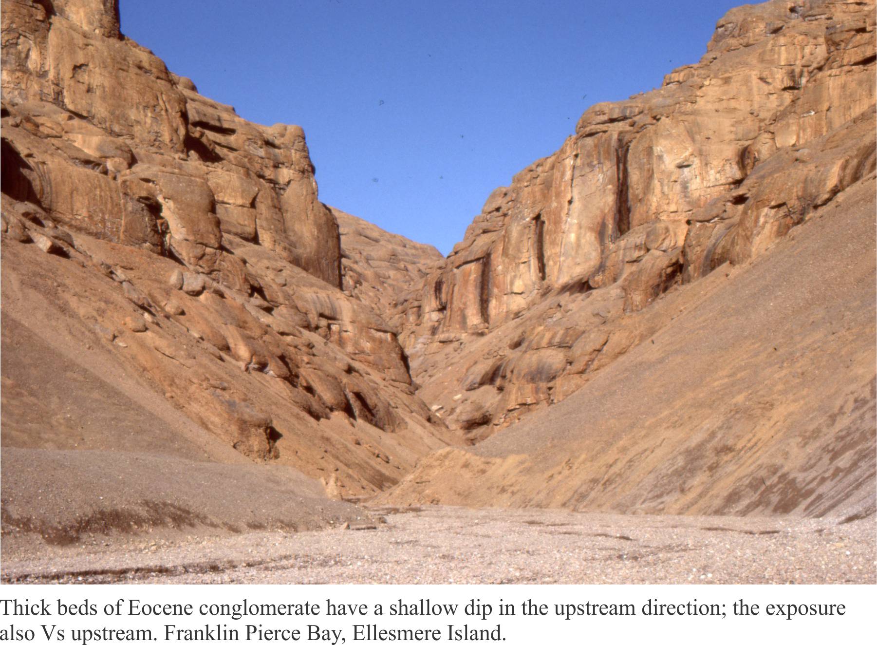
Geologists have borrowed the Rule of Vs to describe the geometry of mapped strata. The Rule also serves to predict the surface location of strata in areas of poor exposure. The Rule applies to the simplest case where bedding is a flat plane, dipping at any angle. Keep in mind that the topographical expression of bedding represents erosional remnants of rock layers that once extended above the present surface; a lot of rock has been removed to produce the topography you see today.
To get a sense of this in three dimensions, take the example where bedding dips upstream (up gradient). Imagine these beds extending above the present surface. In your mind’s eye, whittle away at the strata until your imaginary surface coincides with the present surface. The mapped expression of the beds will show them V-ing upstream in the valley and down gradient on the adjacent ridges.
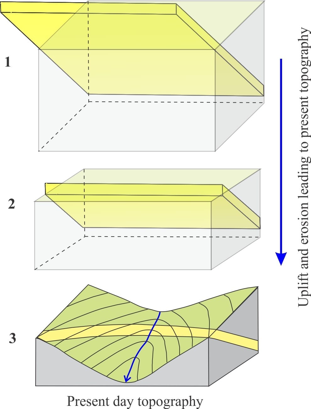
Map expressions for six different bedding orientations are shown in a short animation, in 3D block views and their corresponding map views. I have taken the liberty of modifying the examples shown in Donal M. Ragan’s excellent text Structural Geology: An introduction to geometrical techniques. Pause each frame if you need to spend more time looking at it. The animation shows, in sequence, beds that dip: horizontally, upstream, vertically, downstream dip greater than stream gradient, downstream dip equal to stream gradient, and downstream dip less than stream gradient. The second part of the animation is presented at a faster frame rate to give a more ‘animated’ sense of changing map expressions.
A couple of things to note. There are three exceptions to the Vs rule.
- Vertical beds do not V across the topography
- Bedding that dips parallel to the valley will not V – Outcrops on both sides of the valley will be parallel.
- Beds that dip downstream at an angle less than the stream gradient will V up stream; this is the same as beds that dip upstream. The difference is:
- In the first case the V point (in the stream) will be at a higher elevation than the sides, and
- In the second case, the V point will be at a lower elevation than the sides.
D.M. Ragan, 1968. Structural Geology: An introduction to geometrical techniques. John Wiley & Sons Inc. 166 p. This book is into its 4th Edition.
Some other useful posts in this series:
Solving the three-point problem


2 thoughts on “The Rule of Vs in geological mapping”
Regarding the :28 second video, how do you tell the difference in map view between a bedding plane dipping upstream and a bedding plane dipping downstream at an angle less than stream gradient? These appear to have similar manifestations in map view.
If I’ve read your question correctly, both V upstream – the second case is one of the exceptions (the other two exceptions are for vertical beds and beds at the same angle as the valley). For these diagrams, In the first case (bed dips upstream) the V point (at the stream) is at lower elevation than its sides; and in the second case the V point is higher than its sides. Hope that explanation is reasonable.
Thanks for pointing this out. I should have explained this in the text – I’ll add some notes.