Geological-logo
Geological-logo

The lithofacies of colluvium

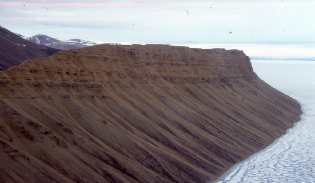
Talus fan colluvium sourced from bluffs of Eocene conglomerate (Buchanan Lake Fm.), Emma Fiord, Ellesmere Island. Depositional mechanisms are primarily mass wasting (rock fall and slide) and slope wash during the Arctic spring thaw. The transfer of colluvium to the shoreline will produce significant improvements in sorting and stratification.

Colluvium – the source for most of Earth’s alluvium

Colluvium is a sedimentary deposit that occurs as a thin layer over much of Earth’s terrestrial surface. Colluvium deposition is dominated by hillslope processes where the dominant force is gravity. Deposits are commonly gravelly, poorly or unsorted, and non-stratified. Colluvium mantles bedrock and unconsolidated sediment alike. It is the ultimate source for most of Earth’s terrigenous, alluvial sediment.

The following historical notes are taken from an excellent review and summary by Miller and Juilleret (2020).

From an Earth science perspective there is a close spatial relationship between colluvium and alluvium – most alluvium is derived from colluvium.  However, the fundamental differences between the two types of deposit are often blurred by historical and recent usage. Both terms have been in use at least since the 17th century. To this day, alluvium has consistently referred to the transport and deposition of sediment in flowing water. Channelized flow is frequently invoked, but modern usage includes sheetflood and sediment gravity flows, particularly debris flows that contribute coarse-grained sediment to alluvial fans.

Early use of the term ‘colluvium’ was reserved for soils and less palatable deposits such as garbage and sewerage. The intervening three centuries have seen changes in the meaning of the term, dispensing with the less desirable qualities but assuming more regional differences. During the 19th century it was also subsumed by an ecclesiastical term – diluvium.

Before Darwin’s opus and despite the published, rational theories espoused by James Hutton and Charles Lyell (early 1800s), the term diluvium was widely used by English, European, and North American geologists to describe the unconsolidated mud, sand, and gravel overlying bedrock. Deposition of diluvium was ascribed to the Noachian deluge. Those promoting the diluvium concept also identified water-laid alluvium as a separate and younger stratigraphic unit. The biblical roots of diluvium were inextricably linked to the widely held 19th century view of Earth’s age, calculated by Bishop Ussher at 4004 BC (or BCE). The term lost its popularity over the later decades of the 19th century as burgeoning geological observation and theory demanded different modes of thinking. For example, deposits identified as diluvium in Europe and Britain were reinterpreted as glacial drift.

The meaning of colluvium during the latter half of the 19th century had morphed to a combination of alluvium and diluvium. By the end of the 19th and beginning of the 20th century the scientific community (but not the creationists) had largely divested itself from the diluvial concept. At this time there were several definitions of ‘colluvium’, but two main streams of thought prevailed, streams that persist in 21st century definitions.


Modern usage

Two main depositional processes dominate modern definitions of colluvium:

  • Mass wasting, usually on hillslopes, where the primary mover of sedimentary fragments is gravity. Hillslope processes in include rockfalls, landslides, creep, freeze-thaw, and solifluction.
  • Slope wash by discontinuous, non-channelized sheet flow of water during precipitation events and spring thaw.

Common definitions of colluvium that emerge from these two processes are summarized in the table below – modified from Miller and Juilleret, 2020, Table 1 (see link above). The definitions tend to use one or combinations of both depositional processes.
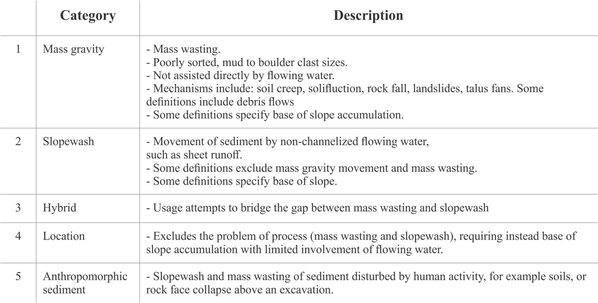
 

Categories of sediment type and depositional process that can be used to formulate definitions of colluvium. Modified from Table 1, Miller and Juillerete, 2020 (see link above).

The differences among these categories depend very much on how the term colluvium has and is being used, geologically and/or technically.

In the absence of a single all-encompassing definition, Miller and Juillerete suggest the following criteria be used to “structure” future definitions:

Colluvium = Transported regolith formed by the accumulation of clastic sediments by mass-gravity movement where water can function as a lubricant. Deposits exhibit heterogeneous particle sizes that frequently include angular fragments of rock, poor sorting, and little to no stratification. Usually found on slopes and at their bases.”


Colluvium lithofacies

Some examples of what I think constitute colluvium lithofacies are shown below. They emphasise the heterogeneity of the sediment, sediment texture, and absence of stratification.  The examples include slope and base of slope colluvium derived from mass wasting, slope wash, and gravitational creep, but do not include sediment gravity flows.
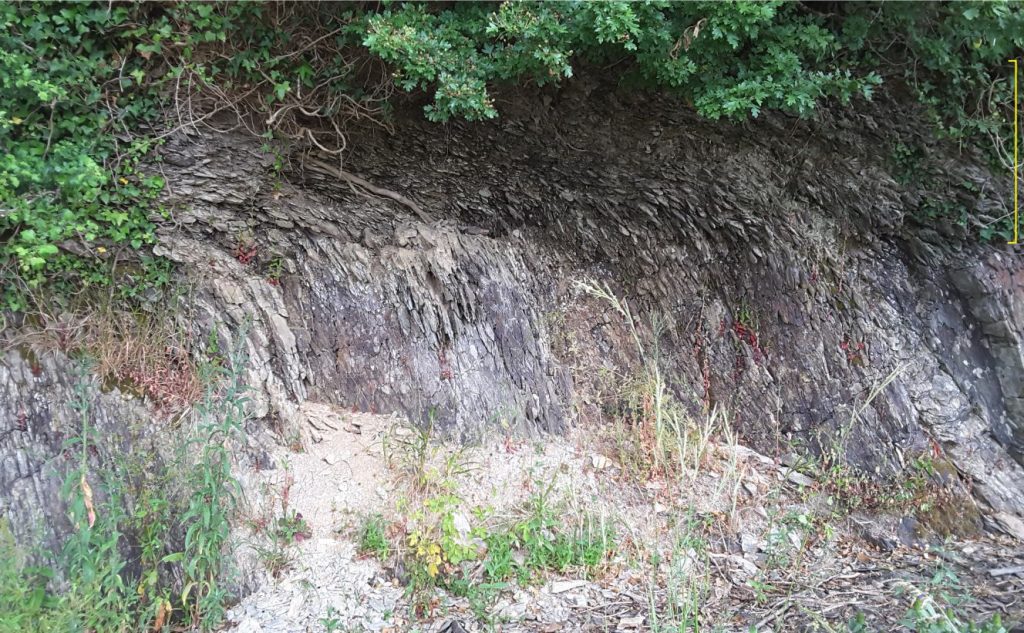
Down-slope gravitational soil creep has folded and fragmented the upper surface of this Devonian shale, forming a colluvium layer consisting almost entirely of shale cleavage fragments. The fragmented shale is overlain by a modern soil that has been disrupted by various land use activities. In this example, use of the term colluvium can be confined to the overturned and fragmented shale (yellow bracket) (Category 1, mass wasting), or a combination of the fragmented shale and topsoil (Category 5). Both usages are correct, and the choice of one over the other will depend on geological or technical necessity. The reasons for choosing one or the other usages should be stated explicitly.


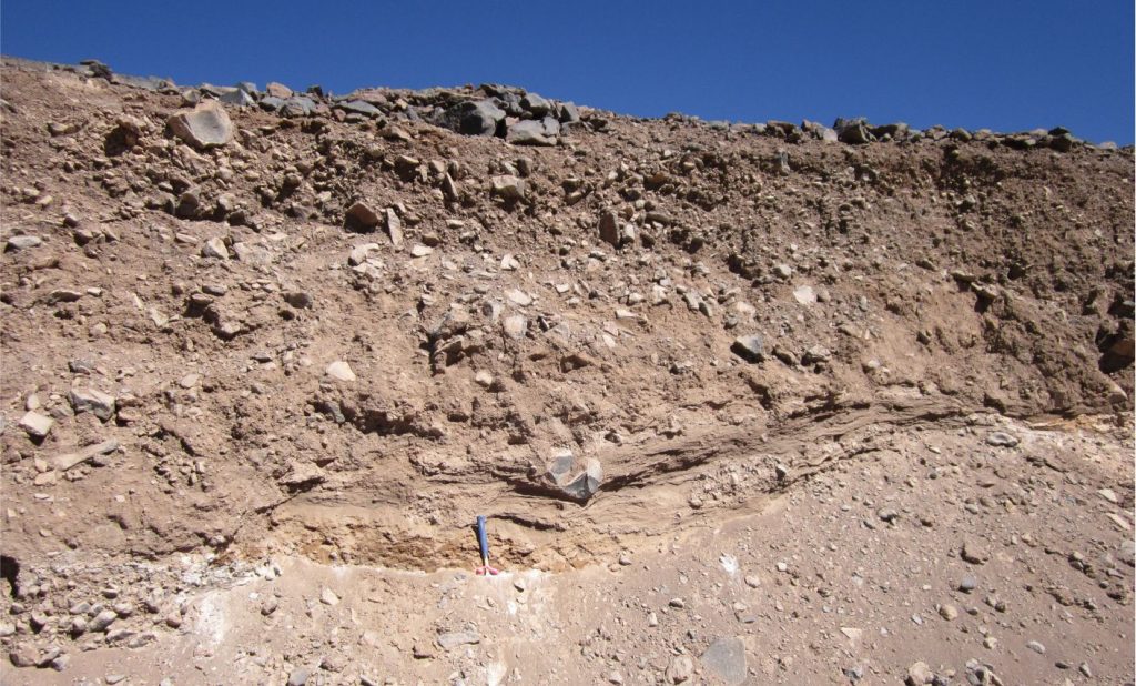
A non-sorted, non-stratified colluvium deposit consisting of angular fragments of andesite derived primarily by seasonal mass wasting of lava flows on the flanks of a Miocene volcano, Chilean Altiplano. The main depositional processes here are rock fall, rolling, downslope sliding, and creep (Category 1 in the table above). The basal layer (at the hammer) contains weak layering possibly derived from slope wash. The climate here is hyper-arid and at elevations greater than 4000 m a.s.l. winter freezing is severe. Most of the mass wasting occurs during spring thaw but sediment transport can also include intermittent sheet floods and debris flows.


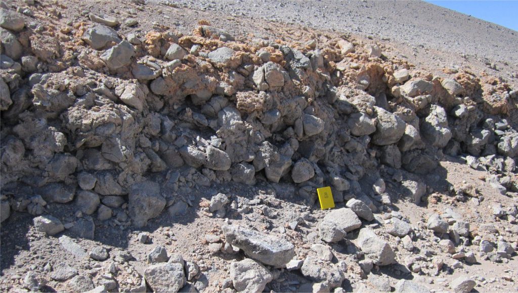
Section through a boulder colluvial deposit on the flanks of an Eocene, andesite volcanic cone. The primary depositional mechanism was rock fall down a talus fan, such that the accumulation is thickest and coarsest at the base of slope (Category 1 in the table above). The angular fragments are close fitting, forming a clast-supported framework with poorly sorted, finer grained clastic material filling the interstices. The top 50-100 cm of the unit are cemented by very porous, ferroan calcite (orange). Chilean Altiplano. The climate here is identical to that in the previous image.


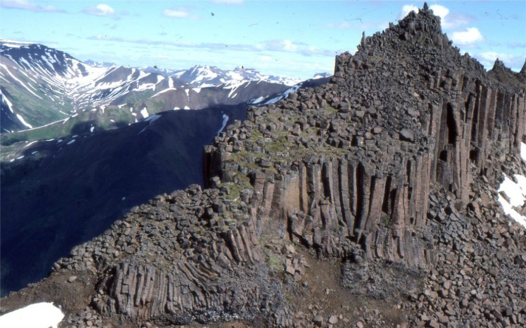
The upper part of a talus fan where blocks of columnar-jointed basalt accumulate via rockfall (Category 1 in the table above). The deposit here and farther down slope has clast-supported frameworks. Polygonal clast shapes are determined by the vertical and horizontal joint patterns of lava flows. The basalt flows are part of the Edziza Volcanic Complex (northern British Columbia) and are 1-2 million years old.


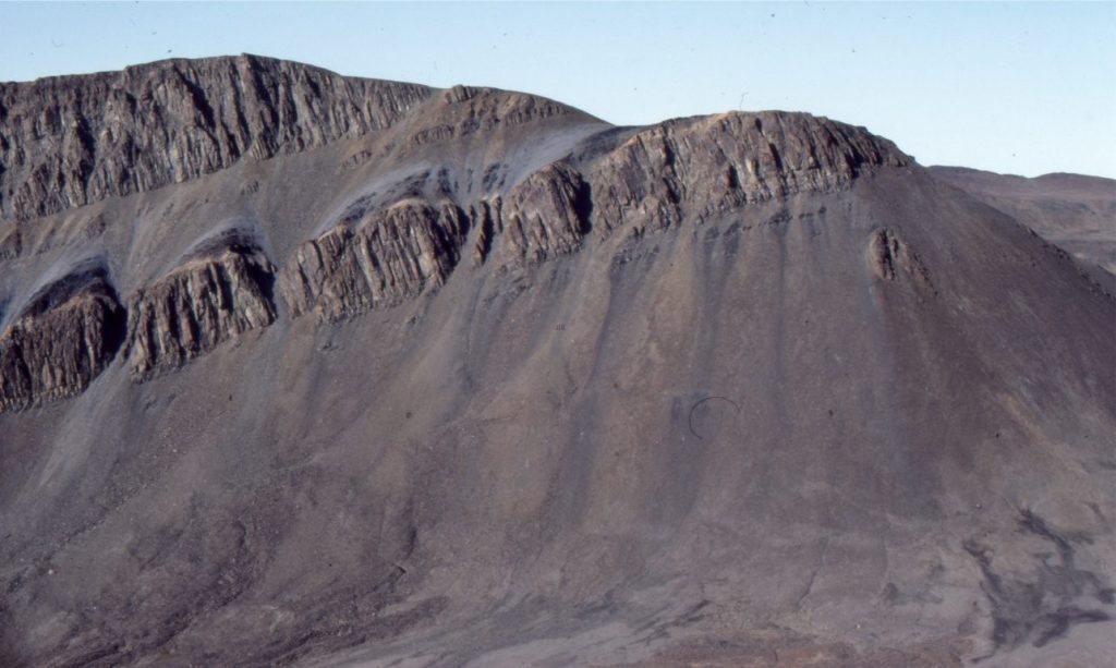
Talus fans exiting joint-controlled erosional notches in diabase sills that intrude Triassic shale, Axel Heiberg Island, Canadian Arctic. The uppermost sill is about 30 m thick. The dominant process here is rock fall (Category 1 in the table above), but slope wash (sheet wash) is also responsible for distributing talus during spring thaw (Category 2), so this colluvium might be categorised as type 3 (hybrid). The talus (colluvium) deposits consist of small shale fragments and larger clasts of diabase; the largest clasts are accumulating at the base of slope.


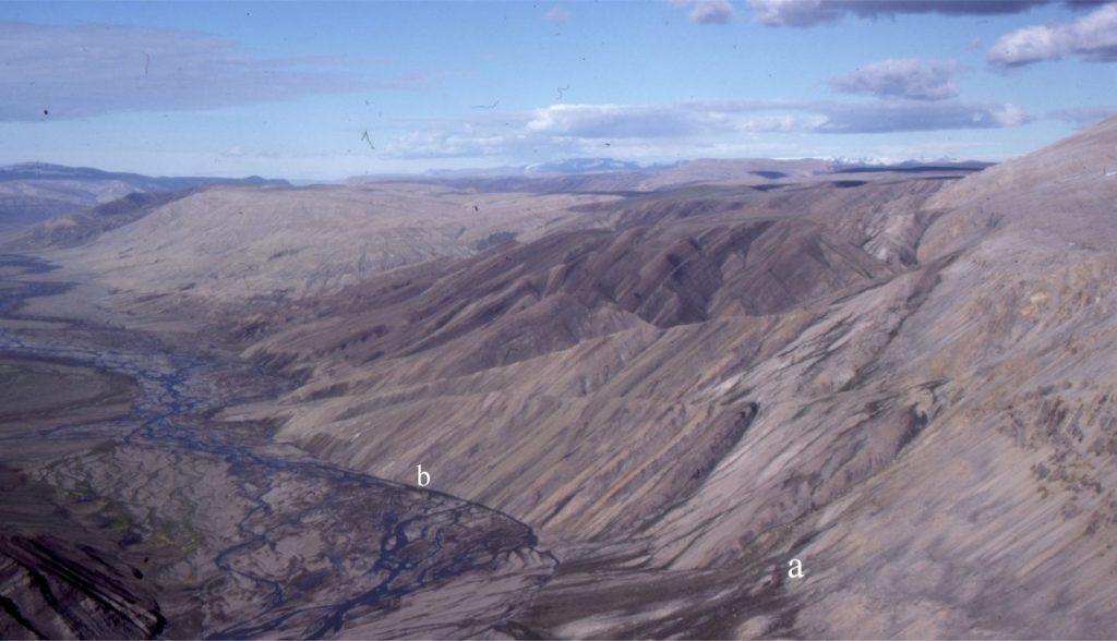
This view shows the transition from colluvium to alluvium via different landforms. The hill slopes flanking the braided river (centre-right) are underlain by steep dip-slopes of interbedded Paleocene-Eocene sandstone and shale. Small talus fans are accumulating at the base of these slopes. The colluvium is a mix of Category 1 and 2 types – mass wasting and slope wash (i.e., Type 3 – hybrid), the latter forming during the Arctic spring thaw. In the foreground (a) the talus fans merge at an abrupt break in slope into small alluvial fans. At (b) the talus fans merge abruptly with the braided river channels. Sediment distribution beyond the confines of the colluvium at (a) and (b) occurs primarily by channelized flow. Mt. Moore area, southern Ellesmere Island.


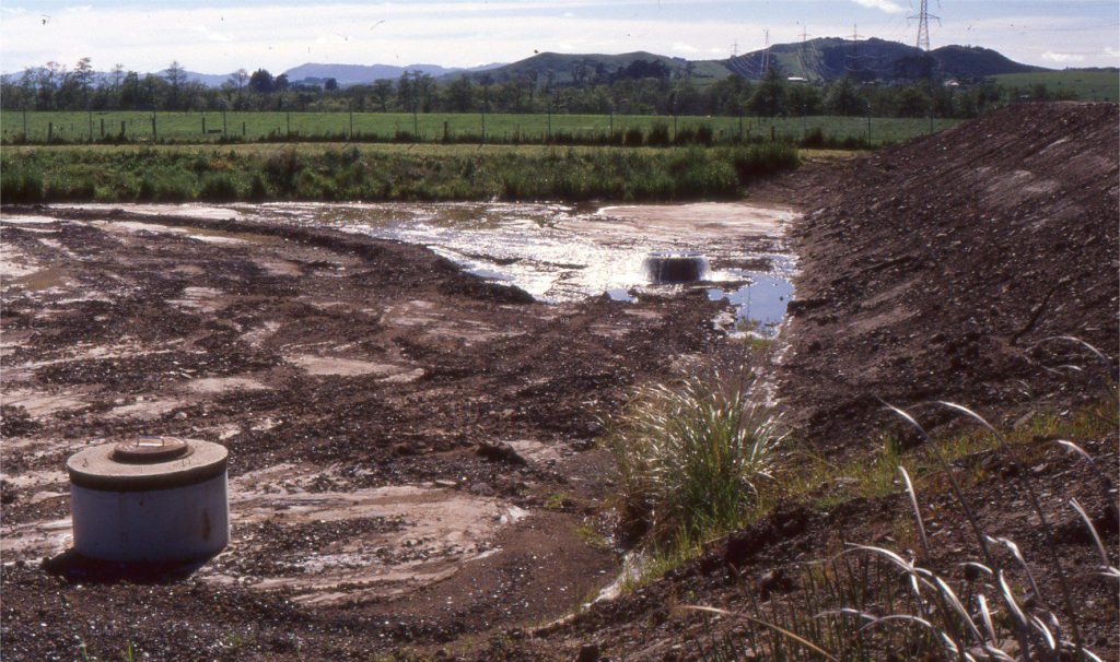
Anthropogenic colluvium (Category 5) created by excavation and redistribution of Late Pleistocene-Holocene flood-plain sand and gravel (flanking Waikato River). The original textural and stratigraphic characteristics of the flood plain deposits have been destroyed and replaced by a non-sorted, haphazardly stratified to non-stratified colluvium that is periodically redistributed by sheet flood runoff. The well-head right-centre is an artesian flowing outlet connected to the reservoir behind the embankment. Located near Huntly, New Zealand.


Sandstone lithofacies

Sedimentary lithofacies – An introduction

Ripple lithofacies: Ubiquitous bedforms

Climbing ripple lithofacies

Ripple lithofacies influenced by tides

Tabular and trough crossbed lithofacies

Laminated sandstone lithofacies

Low-angle crossbedded sandstone

Hummocky and swaley cross-stratification

Antidune lithofacies

Lithofacies beyond supercritical antidunes

Subaqueous dunes influenced by tides

Gravel lithofacies

Introducing coarse-grained lithofacies

Crossbedded gravel lithofacies

Beach and shoreface gravels

Debris flow lithofacies

The lithofacies of mountain streams

Leave a Comment

Your email address will not be published. Required fields are marked *

Archives
Categories
Recent Posts
Scroll to Top