Continental Drift was the leading hypothesis for continental aggregation, prior to plate tectonics
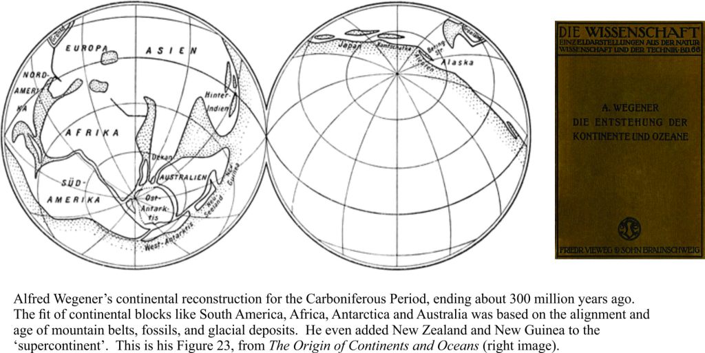
German meteorologist Alfred Wegener, in a fit of creativity, presented his ideas about drifting continents to a 1912 geological meeting in Frankfurt. He published an expanded version of his theory in 1915 – The Origin of the Continents and Oceans, to muted applause and resounding derision. I found this quote by Russian contemporary, Vladimir Beloussov, in Arthur Holmes’ Principles of Geology wherein Beloussov quips in less than glowing terms of the “…total vacuousness and sterility of the hypothesis”. The tenor of this remark was probably typical of Wegener’s detractors. In fact, even today, certain scientific hypotheses and theories suffer the slings and arrows of equally vacuous remarks from the scientifically challenged. As it turned out, Wegener’s revolutionary ideas were the vital spark that gave birth to modern Plate Tectonics.
Unlike his contemporaries, who regarded all large-scale global movements of the crust as vertical (mountain ranges, volcanoes, fault scarps), Wegener postulated that the continental masses had moved horizontally; that they had once been conjoined, but had since drifted apart to where they now reside. He regarded the jigsaw-fit of eastern South American and western Africa as more than coincidence; the fit is actually quite extraordinary. He was impressed by the congruity of mountain ranges on both continents, deposits of ancient glaciations from about 350-240 million years, and the commonality of certain fossil groups (especially plants) that could not have existed if both continents had been separated by a large ocean.
Wegener’s ideas challenged entrenched notions of continental permanency, that vertical motions of the crust could explain the large-scale features of the earth, and that land bridges conveniently provided passage for animals to stroll from one distant land mass to another. As one commentator put it, Wegener’s ideas challenged pretty well everything geologists had learned.
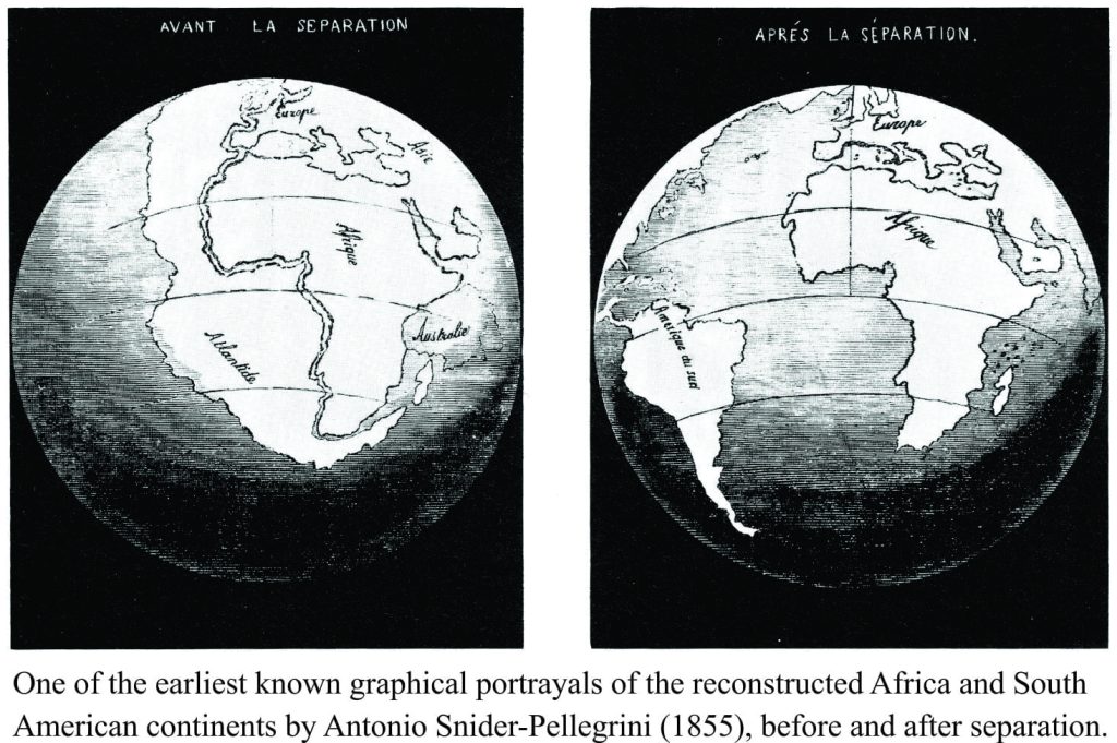
Wegener wasn’t the first to wonder about the fit between South America and Africa. Francois Placet in 1668 suggested a connection that was breached during the Noachian Deluge. Alexander von Humboldt in 1800 also noted the similarities in mountains, coal and fossils between the two continents. The biblical deluge was again invoked in 1855 by Antonio Snider-Pellegrini to break apart the joined continents; his graphical reconstruction of what subsequently became known as Gondwana, is one of the earliest and is remarkably good, even if his explanation was a bit haywire.
F.B Taylor, an American geologist, also published a brief description of joined continents. His attempt at an explanation for how ‘drift’ occurred relied on the tidal friction generated by earth’s capture of the moon during the Cretaceous Period – in other words earth was without a moon for most of geological history. Needless to say, Taylor’s hypothesis didn’t really catch on.
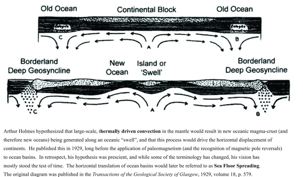
Wegener’s 1915 account was, at the time, the most comprehensive rendering of Continental Drift. One of the main scientific criticisms of the theory was the absence of data that would explain how drift actually took place; to move the continents apart required humungous amounts of stretching (rifting) and horizontal movement of the crust. Arthur Holmes had hypothesized (1928-29) that large, thermal convection cells operated in the mantle and that ‘floating’ crust was carried by these cells, like a conveyor belt; this was also a mechanism that created new oceanic crust. But Holmes idea, brilliant as it was, had little or no supporting empirical evidence, particularly for processes that operated on such a large scale.
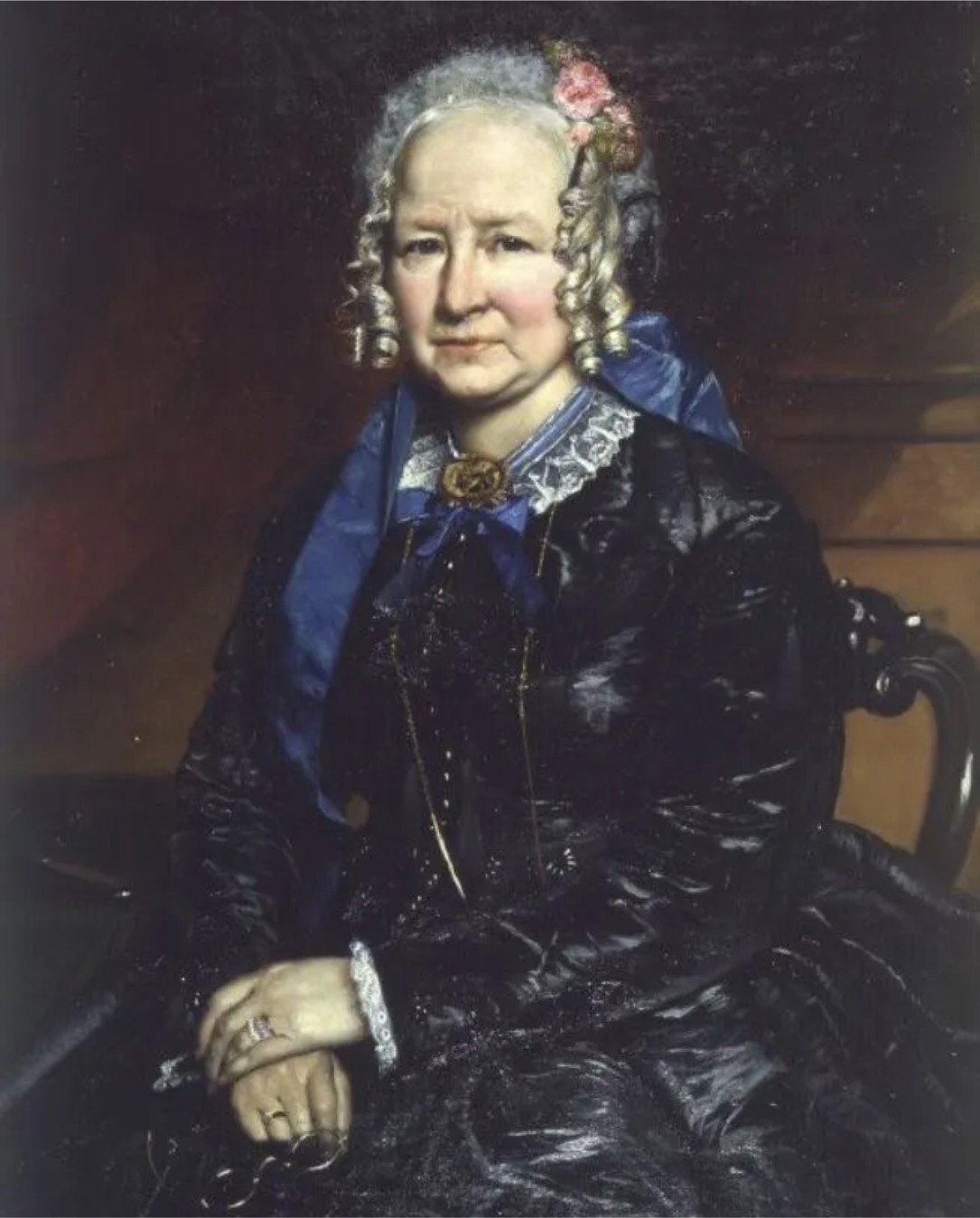
It wasn’t until the 1950s and 60s, with new seismic, magnetic and gravity data providing a different perspective of the earth’s crust and interior, that ideas about possible drift mechanisms began to gel. Marie Tharpe was the first to recognise mid-ocean ridges in the Atlantic, and importantly, the associated rift systems that extended many 1000s of km through the Atlantic and other ocean basins. The implications for mid-ocean stretching were not lost of Tharpe. Unfortunately the patriarchy largely ignored her, and others like Bruce Heezen received most of the credit. Based on these discoveries, Harry Hess proposed in 1962 that new oceanic crust evolved as magma erupted from huge, mid-ocean volcanic rift systems, like the one that traverses the length of the North and South Atlantic (Robert Dietz, another geologist made a similar proposal almost simultaneously). As magma erupted from the ridge, it cooled and spread outwards – hence the origin of the term Sea Floor Spreading.
Striped oceans
The swath of new data from ocean basins that permitted these revolutionary ideas included the measurement of fossil magnetic fields in oceanic volcanic rock. It had been discovered some years earlier that north and south magnetic poles had swapped places many times throughout geological history. Fred Vine and Drummond Matthews (UK), and Canadian geophysicist Lawrence Morley surmised in 1963 that new ocean crust would inherit the ambient magnetic field at the time of its formation; the magnetic field would show either normal (north) or reversed (south) polarity. If the spreading of oceanic crust moves like a conveyor belt away from the mid-ocean volcanic rift, then the rocks should record successive magnetic reversals. Furthermore, the magnetic anomalies should be symmetric either side of the mid-ocean ridge
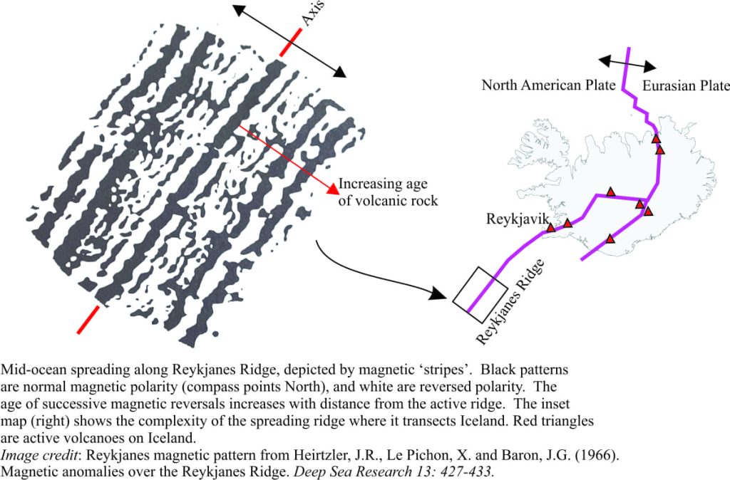 Although the stripyness of magnetic anomalies across ocean crust had been established by the early 1960s, it was an experiment conducted across the Reykjanes Ridge that provided convincing evidence for the Vine-Matthews-Morley hypothesis. Reykjanes Ridge is the extension of the North Atlantic mid-ocean ridge, that also transects Iceland. The results, published in 1966, showed magnetic anomalies that were both parallel to, and symmetrical about the ridge. Furthermore, individual ‘stripes’ could be traced 100s and even 1000s of kilometres across the oceans. Subsequent radiometric dating of rocks in this, and other oceans, further demonstrated the increasing age of rocks with distance from the ridge. Knowing the age also allows the calculation of rates of ocean crust spreading (rates commonly measured in millimetres per year). In the decades since, geophysicists and geologists have generated geomagnetic maps for most of our oceans, and compiled records of ocean basin evolution spanning the last 200 million years.
The late 1950s and 1960s witnessed the fortunate combination of new geophysics data and fertile scientific minds; sea floor spreading eventually morphed into plate tectonics, the revolutionary theory that completely changed the way we think about our dynamic earth – mountains that are built and eventually laid low, earthquakes and chains of volcanoes, our changing oceans, climate, and biological evolution, can all be considered in the context of plate tectonics. It was a paradigm shift the equal of Darwin’s evolution and Einstein’s space. It began with the equally fertile mind of Alfred Wegener.
Some of the important publications that map this scientific and intellectual journey are listed below:
Francois Placet, 1668: The Corruption of the Great and the Little World.
Antonio Snider-Pellegrini, 1858. La Création et ses mystères dévoilés (The Creation and its Mysteries Unveiled)
FB Taylor, 1908, Geological Society of America v. 21, p. 179–226.
Alfred Wegnener, 1915. Die Entstehung die Kontinente und Ozeane – The Origin of Continents and Oceans; A facsimilie of this volume is available online at Project Gutenberg
F.J. Vine and D.H.Matthews, 1963. Magnetic anomalies over oceanic ridges. Nature, Sept 7, 1963
H. Hess. 1962. The history of ocean basins.
Arthur Holmes. Principles of Physical Geology, 1st Edition 1944, 2nd Edition 1965.
Heirtzler, J.R., Le Pichon, X. and Baron, J.G. (1966). Magnetic anomalies over the Reykjanes Ridge. Deep Sea Research 13: 427-433.
Allan Cox, 1973. Plate Tectonics and geomagnetic reversals. Freeman & Co. This is a compilation of papers by some of the principle players in 1960s – early 1970s development of the PT revolution. It is still a great read.
