This is the second of three posts on tempestites:
1 Storms and storm surges: Forces at play
3 Evolving tempestite lithofacies models
If there is one suite of sedimentary structures that focuses our attention on shelf or platform dynamics, it is hummocky (HCS) and swaley cross-stratification (SWS). You might be forgiven for thinking that no shelf succession is complete without either or both of these bedforms.
There is consensus that this bedform duo is the product of storms, based on a substantial outcrop database, theoretical considerations (e.g., Myrow and Southard, 1996), and flow experiments (e.g., Dumas and Arnott, 2006), but only a sparse database of bottom-current storm-flow characteristics. They are part of a suite of sedimentary deposits and bedforms called tempestites. They represent depositional events that are distinct from fairweather conditions. There is general agreement that HCS deposits are the product of oscillatory storm-wave orbital bottom currents or bottom-hugging density currents (e.g., turbidity currents) that have been modified by storm waves (i.e., combined flow). Despite these overarching interpretations, the depositional processes responsible for these structures remain a matter of debate (e.g., Duke et al., 1991; Myrow, 2020).
The debate is centred around two important questions:
- How is sediment delivered and distributed across shelves and deltas during relatively short-lived storm events. – a question that requires us to evaluate the relative roles of downslope (shore-normal), unidirectional, bottom-hugging currents versus geostrophic currents that flow parallel or obliquely to shorelines?
- At the sediment-water interface, what are the relative contributions of storm-wave orbitals and storm-induced unidirectional currents to the development of bedforms like HCS (excluding ambient tidal currents and fairweather along-shore currents)?
Boundary layers in stormy waters
Myrow and Southard’s 1996 elegant description of storm wave and current dynamics is as relevant now as it was nearly three decades ago. An important component of their model deals with the delivery of sediment across a shelf. Ancient tempestite deposits can be 10s of centimetres and even metres thick, which means that substantial volumes of sediment were moved across a shelf during relatively short-lived events. How this is facilitated depends on how energy and shear stresses are partitioned through the water column and at the sediment-water interface, particularly in the bottom boundary layer of shelf and delta water masses.
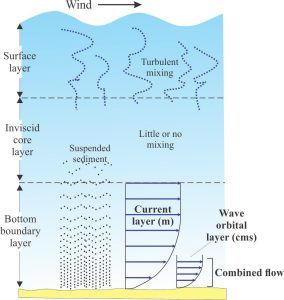
The diagram below is modified (slightly) from Myrow and Southard (their Figure 1). It shows three distinct layers in waters at average shelf depths within the core geostrophic flow. The location of wave base across a shelf or delta platform is also an important boundary because it limits the depth of wave interaction at the sediment interface.

- A surface boundary layer that is maintained by excessive turbulence and mixing. Fine sediment in suspension, for example that derived from wave reworking of the shoreface, or from hypopycnal flows, may reside in this layer for some time and may be deposited long after a storm has ended (which begs the question – should it be included in the definition of tempestites?).
- An inviscid middle layer in which viscous forces are small (i.e., Reynolds numbers are relatively high because inertial flow dominates).
- A bottom layer where the efficiency of sediment transport depends on two overlapping processes; this layer is where all the sedimentological action takes place:
- A relatively thin layer (centimetres) at the boundary between wave orbitals and the sea floor, where shear stresses are directed alternately onshore and offshore and, because of wave refraction, the motion is normal to the shoreline.
- A thicker layer of unidirectional currents (a few metres) that are directed offshore during intense storms. These bottom currents are the result of coastal setup. They overlap the wave-orbital motion to produce combined flow in the lower layer.
The critical forces at play
The forces that influence sediment transport and deposition in the bottom layer include:
- Offshore directed hydraulic pressures, the gradient of which depends on the magnitude of the coastal setup. Coastal setup refers to the elevation of sea level at the coast, where water masses pile up because of wind shear and Ekman Veering of currents that flow at right angles to the wind direction (deflecting to the right in the northern hemisphere). The magnitude of the setup depends on storm duration, wind direction and strength, wave fetch, and the amplifying effects of coastal geomorphology. A seaward pressure gradient develops because the elevated water mass is gravitationally unstable and will tend to dissipate as the storm wanes. Storm cells are also associated with low atmospheric pressures that cause sea levels to rise, but this component only accounts for about 5% of the coastal setup.
- Coriolis forces act at 90o to the wind, deflecting currents to the right in the northern hemisphere. As a storm develops, and depending on the wind direction, Ekman veering will push water masses shoreward and contribute to the coastal setup. Coriolis deflection of the seaward return flow from coastal setup produces isobath-parallel (shore-parallel) geostrophic flow.
- Friction forces exist where wave orbitals interact with the substrate. These forces increase from storm wave-base towards the shoreline. Wave orbitals tend to be more symmetrical in deep water, and increasingly elliptical towards the shore (flattened approximately horizontally). Orbital velocities also change with the passage of a storm, as wave heights build over time, but also because winds change direction as cyclonic wind flow passes landward. The magnitude of wave orbital velocity (and therefore shear stress) depends primarily on wave amplitude and period, that also depends on storm duration and fetch.
- Sediment suspended in the water column produces what Myrow and Southard call excess weight forces. The concentration of suspended sediment tends to be greatest near the shoreline, decreasing seaward with distance and water depth. Thus, these forces tend to act downslope (seaward). Some of this sediment may be reworked from the sea floor, particularly in the surf zone. However, much sediment is also introduced by rivers and deltas as hypopycnal flows and hyperpycnal flows.
The proportion that each type of force or process influences bedforms and their lateral extent; the thickness of tempestites will vary from place to place and from one storm to the next depending on storm severity, the direction of storm approach along a coast, and coastal geomorphology (e.g., Myrow, 2020, op cit.). Thus, the range of possible lithofacies will also vary from one event to another. Geomorphic systems other than open-ocean shelves, such as large deltas and high-volume rivers, will impact the volume of suspension load and bedload sediment released to adjacent shelves. The response of storm surge encroachment over a delta will also be quite different to that over shelves where river input is minimal; in this case, marine processes will compete with fluvial flood-related processes – recent examples are Bhattacharya et al., 2020, looking at North America delta systems; Vaucher et al., 2023, examining a Late Pleistocene flood delta in Taiwan).
Shore-normal flows or geostrophic flows?
The term “shore-normal” here means bottom-hugging flow normal to shoreline: geostrophic flows parallel isobaths or may be oblique where deflected by seafloor topography. The problems associated with identifying shore-normal or shore-parallel bottom current flows as depositional modes for tempestite deposition is nicely encapsulated by two early publications: Leckie and Krystinik (1989), and Snedden and Nummedal (1991).
Shore-normal flows
Leckie and Krystinik proposed that combined shore-normal density currents (turbidity currents) and wave orbital flows were responsible for the majority of HCS-bearing beds in Cretaceous shelf deposits (Western Canada foreland basin), based on sole mark and parting lineation trends, together with offshore trends in stratigraphic thickness and grain size. Numerous studies have since shown the importance of shore-normal, wave-modified turbidity currents (i.e., combined flow), not only in ancient shelf settings but also across wave-dominated deltas and prodelta slopes where hyperpycnal flows are commonly generated, for example Myrow et al., (2002, Cambrian Shelf – PDF available), Jelby et al., (2019, Cretaceous delta ramp).
Density current flows may be triggered by excess weight forces (noted above), including those generated by plunging hyperpycnal flows, or by resuspension of sediment by storm waves; some excellent examples have been documented in Spitsbergen Cretaceous rocks (Jelby et al., 2019. Op cit.). Zavala (2020, open access) has incorporated HCS in some hyperpycnite lithofacies models.
Geostrophic flows
Storm-generated geostrophic currents develop when Coriolis forces deflect the return flow from coastal setup (the coastal setup pressure gradient is oriented seaward). The interaction of storm wave orbitals with these shore-parallel currents can produce combined flows that parallel or are oblique to the shoreline during the waning stages of storm surging. Snedden and Nummedal (1991, PDF available), while not dismissing the importance of shore-normal processes, made a concerted plug for shore-parallel or oblique geostrophic flows, based on mapping of a distinctive, graded, tempestite bed deposited by Hurricane Carla (1961). Their interpretation was based on measured shore-parallel isopachs and grain size distributions of a storm-deposited sand bed, observed wind forces, and modelled current directions. Likewise, Swift et al., (2006) posit shore parallel storm generated currents to explain bedform, paleocurrent, and sediment distribution in Cretaceous Book Cliff strata (Utah).
Geostrophic flows also interact with waves producing a range of combined-flow bedforms including ripples, dunes, and asymmetrical HCS. However, geostrophic currents are not restricted to the shoreface – they can extend across the shelf beyond storm wave-base where there is no interaction with wave orbitals in the lower boundary layer. In this case, all sediment transport is traction dominated, and bedforms like current ripples, dunes, and lower flow regime plane-bed lamination will form. This suite of bedforms will be coeval with the HCS-dominated tempestites although distinguishing them from other fairweather deposits might be difficult.
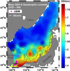
Geostrophic flow across continental shelves and deltas tends to be either parallel or oblique to shore, the latter depending on current deflection by shallow bathymetry, and possibly temperature and salinity barriers. Mapped geostrophic flows in modern seas commonly indicate significant departures from shore-parallelism, particularly in deeper waters beyond the shelf break. The example from East Sea (Japan Sea) shows flow vectors (measured, and calculated from sea level elevations) that define several eddies that coincide with seawater temperature anomalies. The eddies are located beyond the shelf-break, but they may complicate flow dynamics across the shelf during storms.


