Modern marine sabkhas – transitions between carbonates and evaporites
This is part of the How To…series on carbonate rocks
The development of sedimentary facies models based on modern depositional analogues flourished in the 1960s and 70s on the heels of foundational work by 1950s icons (I’m loath to name them because I’m bound to miss someone out). Modern sabkhas were an important part of this trend as a worthy and convenient analogue for many ancient marine evaporite deposits, convenient in the sense that the analogue model was sometimes applied to evaporites even when evidence for “shallow marine conditions” were lacking. It is now firmly established that not all evaporites require a seawater precursor.
Sabkhas and the depositional models derived from them are important because:
- they are part of a sedimentologist’s toolbox for interpreting ancient environments (sedimentary facies, stratigraphy, and geochemistry),
- sabkha diagenesis includes rapid precipitation (and dissolution) of halite at the surface, gypsum-anhydrite in the shallow subsurface, and carbonate hardgrounds,
- they are one of the few sedimentary environments where recent dolomite precipitates,
- they help define the excursions of paleo-shorelines (regression, transgression),
- they place narrow boundary conditions on paleoclimates,
- it is possible to track ancient seawater compositions, and
- they provide a kind of go-between for marine carbonate and evaporite facies.
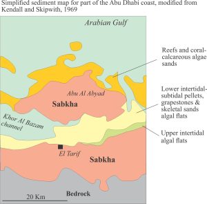
The classic areas of study (one might refer to it informally as the ‘type area’) are the shallow coasts of Abu Dhabi (United Arab Emirates, until 1971 referred to as Trucial states) and Qatar. They are the coastal and inland extensions of the shallow, ramp-like Arabian Gulf. Despite its geological and ecological importance, only about a third of the original Abu Dhabi sabkha coast has escaped urban and industrial encroachment (Lokier, 2013).
Sabkhas are important components of coastal plains, comprising supratidal flats and salt marshes that periodically are flooded by spring tides. They are characterised by a mix of evaporite minerals (predominantly gypsum, anhydrite and halite) and carbonates, and hence are generally restricted to hot arid climates (Abu Dhabi and Qatar sabkhas straddle the Tropic of Cancer). In places, the sabkhas extend inland for 30km; they are remarkably flat having slopes less than 0.1o (Lokier et al. 2018), which means that even minor excursions of relative sea level will have a profound effect on shorelines and associated facies.
Modern sabkhas occur at several other locations (e.g. Sinai Peninsula, and Coorong Lagoon south of Adelaide) but we will focus on Abu Dhabi. Here the coast is bordered by numerous small islands, separated by tidal channels and enclosing lagoons floored by carbonate mud, ooid and skeletal carbonate shoals, and beaches. Small reefs have grown on the seaward margins of some islands. Inland, beach ridges as old as 4000 years provide good evidence for ancient shorelines, successively abandoned during coastal progradation.
A typical transect across the Abu Dhabi coastal plain encounters sedimentary facies that are also represented in shallow stratigraphic sections (revealed in cores). I have drawn on the excellent descriptions in classic papers by Evans et al (1964), Illing et al (1965), Kendall and Skipwith (1969), Bathurst (1976, Chapter 4), and more recent contributions by Paul and Lokier (2017), and Lokier et al. (2017).
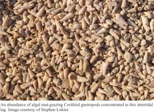
Lower intertidal and subtidal areas are floored primarily by skeletal and pelloidal sands, drained by tidal channels. Local sheltered spots contain aragonite muds. There is a bustling benthic community of molluscs, particularly grazing Cerithiid gastropods and burrowing crabs, echinoderms, foraminifera and calcareous algae.
An important early diagenetic component of this facies belt is a hardground, composed mainly of skeletal debris and cemented by high-Mg calcite, aragonite and some dolomite. Exposed hardgrounds are frequently broken into polygons that may have been caused by desiccation. They occur at the surface in the modern intertidal zone but can be traced landward beneath the sabkha surface. Dating of cemented shells by C14 indicates ages up to 7000 years BP beneath the sabkha. Hardground formation seems to have kept pace with the migrating shoreline during late Holocene progradation.
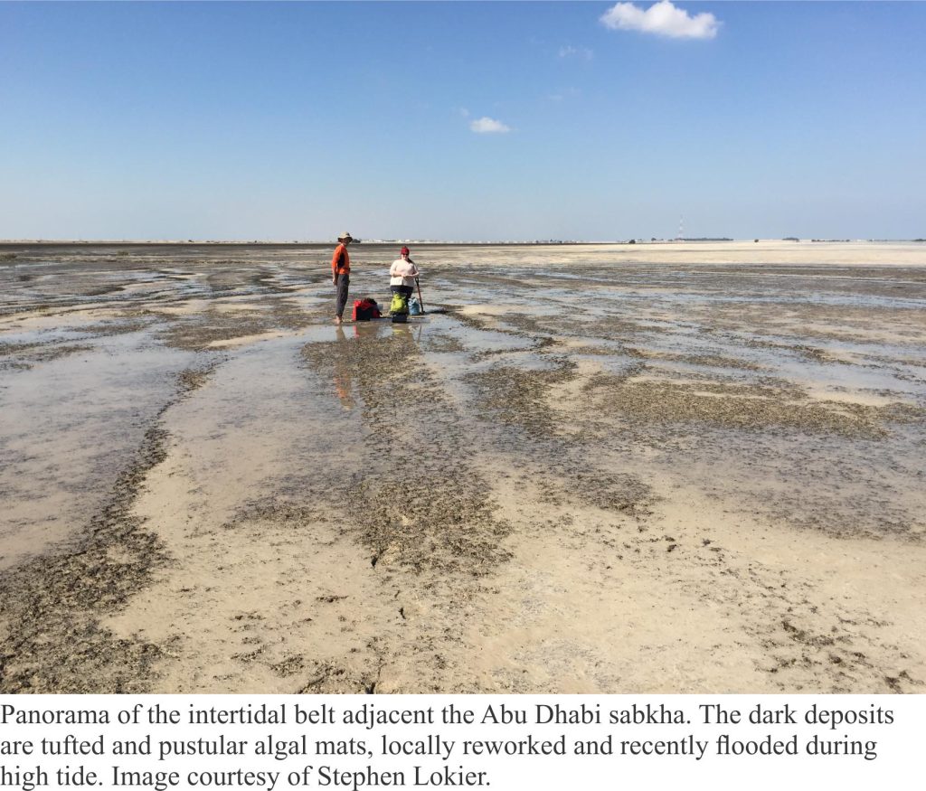
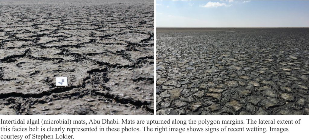
The upper intertidal realm is characterised by a belt of algal mats up to 600 m wide (also referred to as microbial or cyanobacteria mats, and stromatolites). Seaward and landward boundaries of this facies belt are well defined: the former by grazing Cerithiids and crabs that cannot thrive in the elevated salinities higher up-slope; the latter by intense desiccation that characterises the sabkhas. The leathery mats are commonly arranged as decimetre-sized polygons with up-turned and overturned margins, long considered to be the product of desiccation. This hypothesis has been challenged by Lokier et al (2017) who observed breakage during competitive mat growth, such that polygon margins are progressively displaced, overthrust or overturned. Overgrowth by a new generation of microbes can be recognized by the small discordances between mat layers. The polygons sometimes contain gypsum crystal mush. Incipient aragonite and gypsum cements are found beneath some mats.
A range of mat morphologies are present, depending on the regularity of tidal flooding and desiccation. Flatter, or pustular forms are more common in lower intertidal zones. Crinkly and tufted forms tend to occupy upper intertidal regions where desiccation is more intense. Mats that are completely dried are reworked during spring tides.
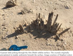
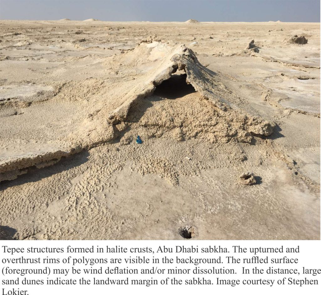
The sabkha facies extends inland from the upper intertidal zone. It tends to be flat, featureless, and devoid of vegetation. Halite crusts are common; large gypsum crystals commonly poke through the surface sediments. The halite is ephemeral – it dissolves during spring tides and any brief periods of rain.
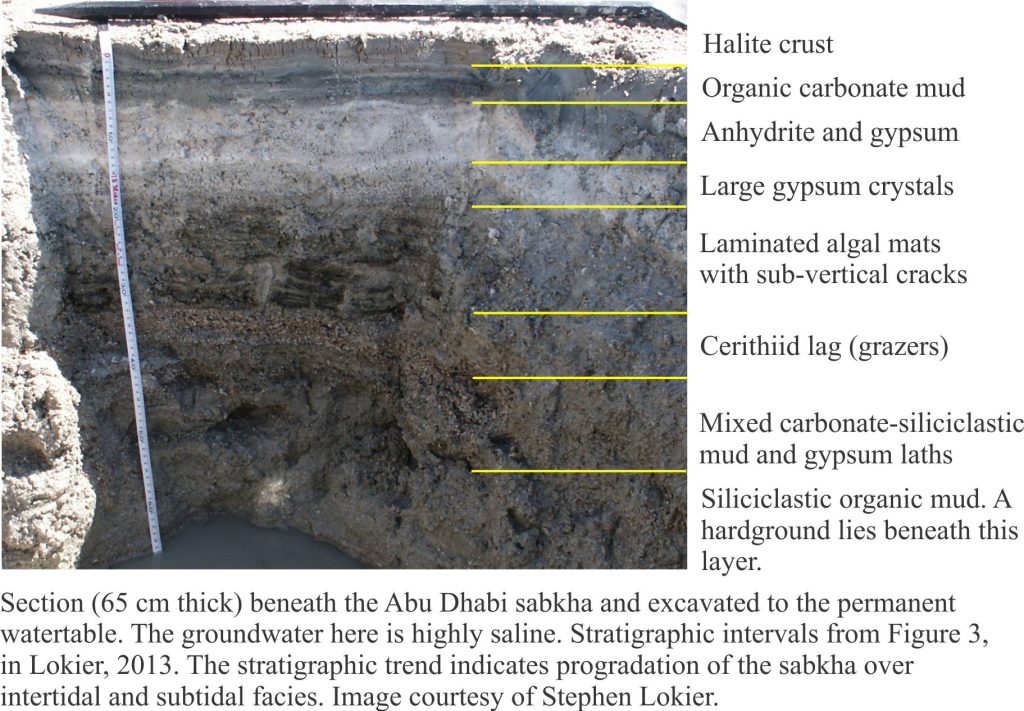
There is an important relationship between the mineralogy of sabkhas, evaporite crystal growth, and depth to the permanent watertable; note that in general, the watertable will rise towards the surface at it approaches the shoreline. These phreatic brines provide the solute for precipitation of gypsum, anhydrite, and halite. Transfer of solute to the overlying (unsaturated) vadose zone and sabkha surface is by evaporative pumping. Thus, most of the gypsum and anhydrite is precipitated in the capillary zone above the watertable, the crystals displacing sediment as they grow (the capillary zone is not permanently saturated with groundwater but is wetted at grain contacts).
Sabkha structures that have reasonable preservation potential are Tepees – conical or inverted ‘V’ structures in broken, cemented crusts and hardgrounds. The crusts are cemented by aragonite and high Mg calcite, but also form in surficial halite. Tepee structures and their associated polygons form by expansion of rapidly cementing surface sediment; the expansion causes breakage that leads to upturned, overturned, and overthrust crust fragments. Tepees formed of carbonate crusts are commonly peritidal, at the junction between the watertable and sediment surface. Those formed in halite are supratidal (like the examples shown here). Tepee structures have been recognized in many ancient carbonates.
The watertable beneath Abu Dhabi sabkhas is usually less than 1 metre below the surface. Groundwater here is highly saline – some measured salinities are 10-20 times that of seawater. The recharge to groundwater needs to balance that lost by intense evaporation. Early workers thought that periodic surface flooding by seawater, or perhaps landward subsurface seepage of seawater would suffice. However, hydrogeological analysis by Sanford and Wood (2001) showed that these processes were relatively minor. Two other processes dominate recharge: upward seepage of groundwater from deeper permeable units, and downward infiltration from rainfall – the latter being most significant. Rainfall also has the potential to change evaporite chemistry – it will dissolve halite (halite has low preservation potential) and may create (temporary) unsaturated conditions for gypsum and anhydrite, resulting in a degree of dissolution.
Stratigraphy
A typical stratigraphic column for Abu Dhabi sabkhas is shown below. The profile (dug to the watertable) records sabkha progradation over intertidal algal mats and cerithiid lags, and subtidal (lagoonal) mixed carbonate plus siliciclastic silts and muds. Displacive gypsum and anhydrite crystals up to 10 cm long occur in several layers. A hardground at the base of this section is the buried equivalent of the hardground presently forming in the intertidal-subtidal facies belts.
The muds, silts and algal mats account for about 60-70% of the local stratigraphy. During compaction and lithification, the thickness of these lithologies will be significantly reduced to the extent that the other layers may appear over-represented. For example, the mat layer, about 150 mm thick would, upon compaction, be represented by a layer no more than a few millimetres thick. In comparison, the thickness of the cerithiid layer may change very little. The halite crust may not be preserved at all!
The sabkha photos generously contributed by Stephen Lokier, are indicate on each figure.
References
G. Evans, C.G.St.C. Kendall and P. Skipwith. 1964. Origin of the coastal flats, the Sabkha of the Trucial Coast, Persian Gulf. Nature, v. 202, p. 759-761.
L.V. Illing, A.J. Wells and J.C.M. Taylor. 1965. Penecontemporary dolomite in the Persian Gulf. In, Dolomitization and limestone diagenesis, a symposium. SEPM Special Publication v.13, p. 89-111.
C.G.St.C. Kendall and P.A.D.E. Skipwith, 1969. Holocene shallow water carbonate and evaporite sediments of Kor al Bazam, Abu Dhabi, southwest Persian Gulf. AAPG Bulletin, v. 53, p. 841-869.
S.W.Lokier. 2013. Coastal Sabkha Perservation in the Arabian Gulf. Geoheritage, v. 5, p.11-22.
S.W. Lokier et al. 2017. A new model for the formation of microbial polygons in a coastal sabkha setting. The Depositional Record, v.3, p. 201-208. Open Access.
S.W. Lokier, W.M. Court, T. Onuma and A. Paul. 2018. Implications of sea level rise in a modern carbonate ramp setting. Geomorphology, v. 304, p. 64-73.
A. Paul and S.W. Lokier, 2017. Holocene marine hardground formation in the Arabian Gulf: Shoreline stabilization, sea level, and early diagenesis in the coastal sabkha of Abu Dhabi. Sedimentary Geology, v. 352, p. 1-13.
W.E. Sanford and W.W. Wood. 2001. Hydrology of the coastal sabkhas of Abu Dhabi, United Arab Emirates. H 358-366.ydrogeology Journal, v.9, p.
Links to other posts in this series:
Mineralogy of carbonates; skeletal grains
Mineralogy of carbonates; non-skeletal grains
Mineralogy of carbonates; lime mud
Mineralogy of carbonates; classification
Mineralogy of carbonates; carbonate factories
Mineralogy of carbonates; basic geochemistry
Mineralogy of carbonates; cements
Mineralogy of carbonates; sea floor diagenesis
Mineralogy of carbonates; Beachrock
Mineralogy of carbonates; deep sea diagenesis
Mineralogy of carbonates; meteoric hydrogeology
Mineralogy of carbonates; Karst
Mineralogy of carbonates; Burial diagenesis
Mineralogy of carbonates; Neomorphism
