This biography is part of the series Pioneering women in Earth Sciences – the link will take you to the main page.
Martine Bertereau Date of birth variously given as 1590, 1600, 1601
Date of death 1642, or 1643.
Martine Bertereau was born into mining. Her family-owned mines in Touraine, France and consequently Martine’s education, that probably involved chatter around the dinner table, immersed her in the qualities of rocks and minerals, alchemy, and hydraulics. It is likely no coincidence that she married in 1610 another mining engineer, Baron de Beausoleil, and hence assumed the title of Baroness. She has also been given the title of first female mineralogist.
And like so many women scientists since, she had to overcome the prejudices of the day, challenged by a society that expected women to be anything other than a miner and geologist. One of the footnotes in her writings begins with:
“But how about what is said by others about a woman who undertakes to dig holes in and pierce mountains: this is too bold, and surpasses the forces and industry of this sex, and perhaps, there is more empty words and vanity in such promises (vices for which flighty persons are often remarked) than the appearance of truth.”
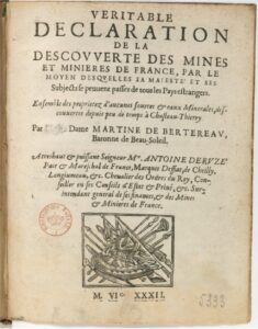
The married couple quickly developed a reputation for locating mineral deposits and mineral spring waters and were employed by Kings, Archdukes, and the Vatican to locate new mines in France, Germany, and Hungary. Martine’s methods of exploration are outlined in her two publications: Véritable déclaration de la découverte des mines et minières, 1632, written after a major survey of mine, and potential mine sites commissioned by French King Henry IV. The second, more a request for monetary compensation, was delivered to Cardinal de Richelieu and addressed as La Restitution de Pluton (1640). Here, she details her 5 rules, or methods (translated quote from Valderrama and Pérez-Pariente, 2012):
“There are five rules that are necessary to learn to know
the places where the metals grow: the first, by opening
the earth, which is the less important; the second, by
the herbs and plants that grow above; the third, by
the taste of the waters that come from those places;
the fourth, by the vapors that rise in the mountains
and valleys at the time of the dawn; the fifth and last,
by means of sixteen metal and hydraulic instruments,that are used above”.
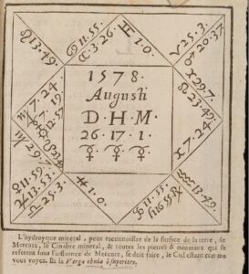
Most of these rules describe methods of exploration that we can identify with today – excavation of earth and rock; accounting for vegetation and landscapes, water sampling and analysis, and various tools that enable sampling, surveying, measuring, and in Martine’s case, divining rods. However, the Restitution also includes astrological charts that appear to have been part of their exploration methodology. Some of her ‘instruments’ were employed to identify minerals under certain star signs, such as emeralds under Venus. Unfortunately, it was the practice of these rules that eventually led to the couple’s downfall.
The couple were accused of calling on demons from the earth, and Martine of witchcraft. Both were imprisoned, Martine in the Chateau de Vincennes (apparently with her daughter), and her husband in the Bastille. It is assumed that they died while incarcerated.
References and other documents
De Bertereau, 1632. Véritable déclaration de la descouverte des mines et minieres de France Beau-Soleil. Can be read or downloaded here.
Stephanie Pain, 2004. Divine deception. New Scientist, October.
Martina Kölbl-Ebert, 2009. How to Find Water: The State of the Art in the Early Seventeenth Century, Deduced From Writings of Martine de Bertereau (1632 and 1640). Earth Sciences History, v. 28(2):204-218.
Ignacio M. P. Valderrama and Joaquín Pérez-Pariente. 2012. Alchemy at the service of mining technology in seventeeth-century Europe, according to the works of Martine De Bertereau and Jean du Chastelet. Bulletin for the History of Chemistry, v. 37, p. 1-13. Open access.
Olivia Campbell, 2022. A Magic Miner & Mineralogist: The mysterious Martine Bertereau, Baroness de Beausoleil.