Geological-logo
Geological-logo

Sedimentary basins

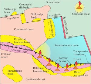
Hypothetical arrangement of tectonic plates, plate boundaries, and sedimentary basins. Modified from Ingersoll, 1988


This series of posts introduces sedimentary basins. We define a sedimentary basin as a region of the crust that is subjected to prolonged subsidence. Subsidence here means generating the space to accommodate up to 10-20 km of sediment; time scales are commonly measured in 106 to 108 years. This amount of subsidence inevitably involves not just the Earth’s crust, but also the upper mantle – in other words, the lithosphere.

The contributions here emphasize the dynamics of basin formation in relation to plate tectonics, particularly plate boundaries, and the manner in which the lithosphere reacts to deformation (stress and strain), changes to its thermal architecture, the addition and subtraction of loads (specifically sedimentary, tectonic, ice, and ocean water loads), and changes to plate boundary trajectories. All of these factors will ultimately determine the shape, size and longevity of basins, and the architecture of their sediment fill.
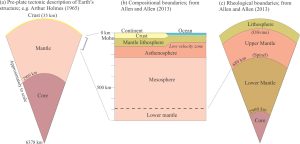
 

Layered structure of the Earth, as seen pre-plate tectonics (left - Arthur Holmes, 1965), and later interpretations based on much improved geophysical observations (Allen and Allen, 2013). The later versions depict the compositional and rheological lithosphere.

Sedimentary basins: Regions of prolonged subsidence

Defining the lithosphere

The rheology of the lithosphere

Isostasy: A lithospheric balancing act
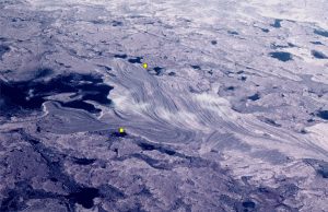
Raised gravel beach ridges resulting from glacio-isostatic rebound following melting of the Laurentide Icesheet. Belcher Islands. The distance between the yellow dots is 500 m. Modern beach is on the left.

The thermal structure of the lithosphere

Classification of sedimentary basins

Stretching the lithosphere: Rift basins

Nascent conjugate, passive margins
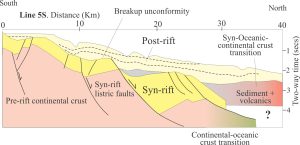
Two profiles across the north (Line 6N) and south (Line 5S) margins of Gulf of Aden interpreted from seismic. Both show the transition from continental crust to crust that is transitional to oceanic. Syn-rift deposits occupy half grabens bound by basin-dipping listric faults, and in turn are unconformably overlain by nascent post-rift, passive margin successions. Prograding clinoforms are well developed in the post-rift succession in Line 6N. Part of the post-rift stage at the basinward end of profile 6N is interpreted as coeval with the continental-oceanic crust transition that probably developed at the beginning of sea floor spreading; the stratigraphic package here includes volcanic accumulations. Modified from Nonn et al. 2019.

Basins formed by lithospheric flexure

Accretionary prisms and forearc basins

Basins formed by strike-slip tectonics

Allochthonous terranes – suspect and exotic
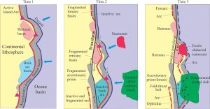
A hypothetical collegiate of terranes across an orogen, transported by strike-slip dislocation, subduction, and obduction. Distances travelled are measured in 100s of kilometres. Modified quite a bit from Helwig, 1974, Fig.1.

Source to sink: Sediment routing systems

Geohistory 1: Accounting for basin subsidence

Geohistory 2: Backstripping tectonic subsidence

A submarine channel complex

How do we identify a basin margin?

Archives
Categories
dip and strike compass
Measuring dip and strike
sandstone classification header
Classification of sandstones
Calcite cemented subarkose, Proterozoic Altyn Fm. southern Alberta
Sandstones in thin section
poles to bedding great circles
Stereographic projection – poles to planes
froude-reynolds-antidunes-header-768x439-1
Fluid flow: Froude and Reynolds numbers
Stokes Law for particle settling in a schematic context of other fluid flow functions
Fluid flow: Stokes Law and particle settling
sedimentary-basins-distribution-1-768x711
Classification of sedimentary basins
Model are representational descriptions are written in different languages - diagrammatic, descriptive, mathematical, and conceptual. They commonly contain variables and dimensionless quantities that permit quantitative analysis of the physical systems the models represent.
Geological models
Scroll to Top