Sedimentary basins are lithosphere-scale structures. They occupy the uppermost levels of tectonic plates, responding to deep-seated processes generated at plate boundaries and sometimes their interiors. How sedimentary basins form and how they evolve depends on the mechanical and thermal properties of the lithosphere.
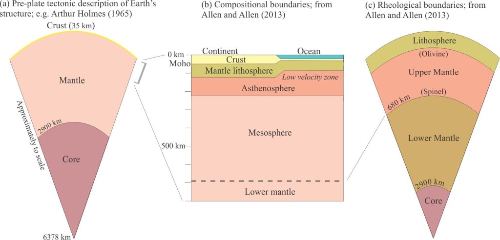
Earth is commonly described in terms of its concentric layers: a central core and mantle that account for 99.5% of Earth’s radial thickness, capped by a very skinny crust. Layer boundaries are identified by changes in composition, or changes in the mechanical behaviour of rocks and fluids, the latter recorded by abrupt changes in seismic wave velocities (the velocity of P- and S-waves increases where density increases and slows in rock materials that are less dense or more fluid).
The idea of an outer crust is centuries old, but it wasn’t until 1909 that geophysicist Andrija Mohorovičić recorded an abrupt seismic P-wave velocity discontinuity at depth. This is the eponymous Moho, the base of the crust. Beneath the Moho lies the upper mantle. At about the same time Joseph Barrell, well-known for his interpretation of cycles in the context of changing baselevels, proposed an hypothesis for the explanation of isostasy and Earth topography by introducing two hypothetical layers: a strong, outer, rigid lithosphere 80-110 km thick and an underlying, fluid or plastic layer – the asthenosphere, 110-480 km thick (Barrell, 1914, a PDF is available from this link). The general idea was that the asthenosphere would respond to lithospheric loading or unloading, by outflow or inflow respectively beneath the load. The first proof for this neat idea was provided by Beno Gutenberg in 1926 who recorded an abrupt decrease in seismic velocities at about 75 km depth; this is now called the Gutenberg discontinuity, or perhaps more commonly, the lithosphere-asthenosphere boundary (or LAB).
Barrell’s brilliant ideas were to have major repercussions 50 years later, providing a mechanism to explain the mobility of rigid tectonic plates over a weaker asthenosphere. The lithosphere is cool, to the extent that convection is not possible; convection occurs in the hotter asthenosphere. How the lithosphere behaves depends on two fundamental properties: its composition, and its mechanical behaviour, or rheology (Allen and Allen, 2013).

The compositional lithosphere
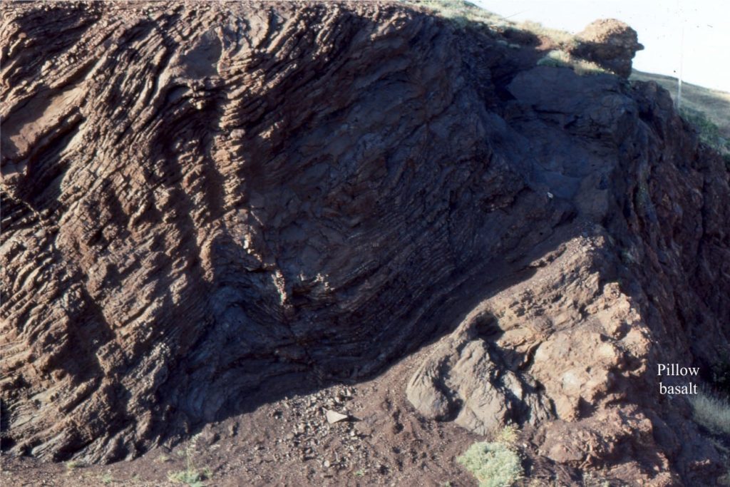
In this model, the lithosphere consists of the crust and uppermost part of the mantle. Oceanic crust is produced at spreading ridges; here it is 3-4 km thick. Oceanic crust evolves according to its thermal history. Crustal thickness increases with age and distance from the spreading ridge as a result of cooling. Cooling eventually results in crustal densities that cannot be sustained gravitationally by the mantle, leading to subduction and crustal recycling. For this reason, oceanic crust tends to be young; the maximum age at present in our ocean basins is Jurassic. A typical cross section of oceanic crust shows a surface veneer of sediment underlain by pillow basalts, and at depth gabbros and olivine-rich peridotites (see the image of radiolarian chert and pillow basalt at top of page).

Continental crust tends to be more felsic in composition, although its deeper levels contain amphibolites and eclogites. For this reason, it remains gravitationally stable with respect to the mantle. Crustal thicknesses average 35 km, but range to 70 km. The Moho tends to be deepest beneath mountain belts. Cratonic blocks contain some of the oldest rocks on Earth, in marked contrast to the reduced potential for aging of oceanic crust.
The upper mantle beneath both oceanic and continental crust consists primarily of olivine; this is based on seismic velocities and mantle samples from uplifted and infaulted wafers at deformed plate margins, from olivine-rich inclusions in lavas, and from very high-pressure minerals such as diamonds in kimberlite pipes.
The rheological lithosphere
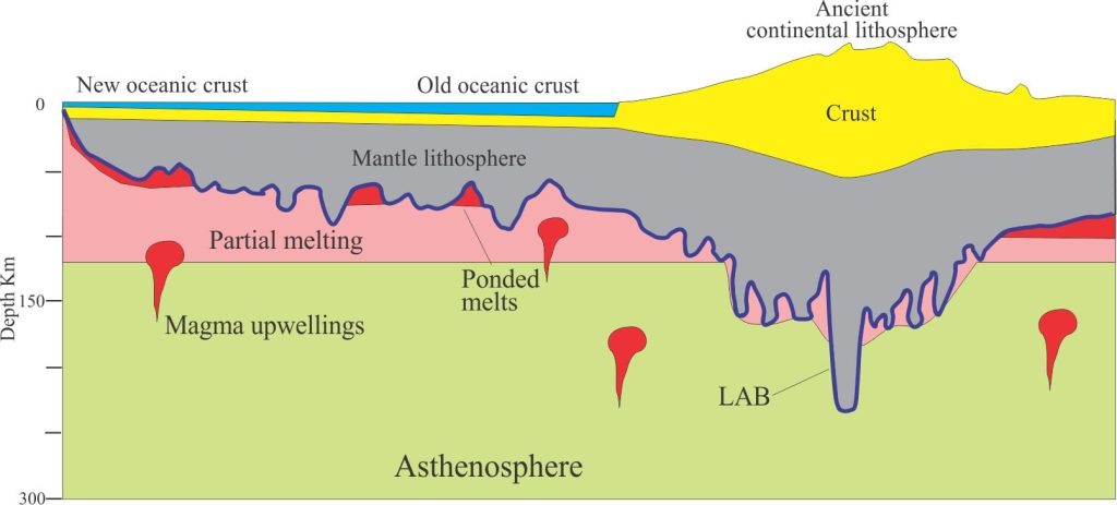
The thickness of the lithosphere is determined to a large extent by its thermal history and as a general rule, older colder lithosphere is thickest. In this case the lithosphere-asthenosphere boundary (LAB) corresponds with the 1100o-1330oC isotherm; this is the temperature range at which mantle rocks begin to melt; it is referred to as the solidus. Note that there is no wholesale melting of the mantle at the solidus because of variations in mineral melting points and the degree of hydration; the greater the degree of hydration, the lower the melting temperatures. Beneath the oceans, the thermal lithosphere ranges from about 5 km (at spreading ridges) to 90 km in older, colder crust. Continental lithosphere commonly ranges from 100-250 km thick.
As recent studies have established (reviewed by Rychert et al, 2020)(open access), the LAB boundary is anything but smooth suggesting that processes other than temperature influence its depth. One explanation gaining some traction is partial melting at variable depths that may be partly controlled by different degrees of hydration. How this might look is shown in the diagram below.

The rigidity of the lithosphere means that it should behave elastically under stress. This behaviour allows the lithosphere to flex, or bend when vertical or horizontal stresses are applied. In the context of sedimentary basins, lithospheric flexure is the prime mechanism of subsidence in foreland-type basins where the loading is generated by stacks of thrusted crustal slabs. Flexure also occurs in response to sediment load in many kinds of basin; this is particularly relevant across passive margins and foreland-type basins. But perhaps the most obvious examples of lithospheric flexure are manifested as rebound of landmasses following melting of an ice sheet. In fact, post-glacial rebound over the last 10,000 years has been so rapid (from a geological perspective) that we can, over a few decades, witness landform changes such as shoreline migration.
Topics in this series
Sedimentary basins: Regions of prolonged subsidence
The rheology of the lithosphere
Isostasy: A lithospheric balancing act
The thermal structure of the lithosphere
Classification of sedimentary basins
Stretching the lithosphere: Rift basins
Nascent conjugate, passive margins
Basins formed by lithospheric flexure
Accretionary prisms and forearc basins
Basins formed by strike-slip tectonics
Allochthonous terranes – suspect and exotic
Source to sink: Sediment routing systems
Geohistory 1: Accounting for basin subsidence
Geohistory 2: Backstripping tectonic subsidence


