The Atlas, as are all blogs, is a publication. If you use the images, please acknowledge their source (it is the polite, and professional thing to do).
Stratigraphy is a cornerstone (sic) of the earth sciences. With it, we unravel earth’s history, the sequence of events and processes that have given us the world we live in. It is the story, written in rocks and fluids, of the physical, chemical, and biological world. Perhaps we should now include the social and psychological spheres of our existence, as part of the latest geological period, the Anthropocene – layer upon layer of human thought, actions, consequences.
Unconformities are a fundamental part of Stratigraphy. They are that part of the rock record in which time and rock are missing – periods of time in which rocks either did not form, or if they did form were subsequently removed. In both cases, the “missing” information tells us that something happened; the ‘something’ may have been local, confined to our own backyard, or of global extent such as extinction events, the construction of mountains or destruction of oceans. So, geologists who find unconformities don’t throw up their hands in despair; they rub their hands in glee at the promise of so many possible explanations.
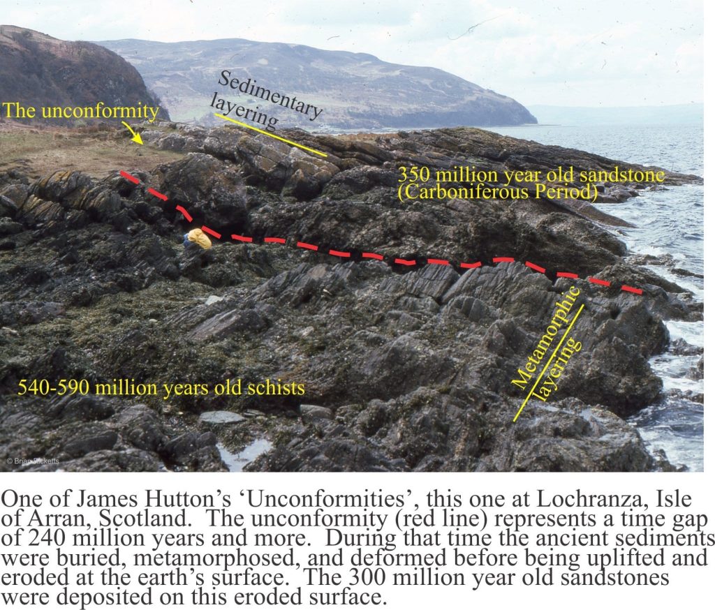
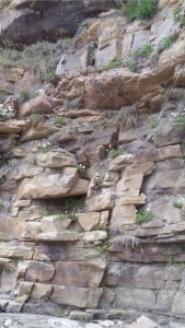
What better example to begin with than one of James Hutton’s classic localities on Arran, west Scotland (image above). This is the unconformity at Lochranza where Carboniferous sandstone overlies Late Precambrian Dalradian schist. The unconformity here represents about 240 million years of time, seemingly missing, and yet it also represents a period of mountain building, where deeply buried metamorphic rocks were uplifted many kilometres, exposed and worn down by the vagaries of ancient weather systems, and buried by sand shed from the rising mountains. This tale of the evolving earth is encapsulated in the seemingly innocuous contact between the two different groups of rock.
Lochranza, Scotland
An uncluttered view of Hutton’s unconformity at Lochranza (same location as the image above)Basal conglomerate of the Carboniferous succession that onlaps Dalradian schist at Lochranza. Hammer is at the unconformity.
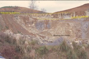
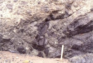
Proterozoic Gowganda Formation
The unconformity between Archean metavolcanic and plutonic rocks at Cobalt, Ontario, and the ProterozoicGowganda Formation, is marked by a regolith of blocky granodiorite and granite, that is overlain by diamictites deposited during Early Proterozoic glaciation. Two images follow.
The regolith here is of close-fitting, very angular blocks of granodiorite, possibly fractured during freeze-thaw.
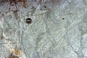
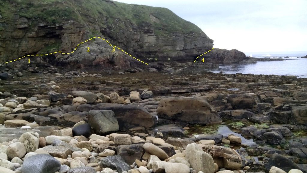
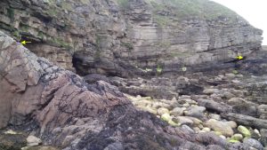
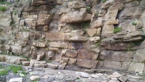
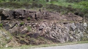
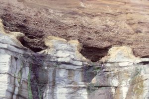
Old Red Sandstone (ORS) on Moine schists, Portskerra, Scotland
The ORS is a mixed bag of sedimentary rocks, mostly Devonian, but extending into the late Silurian and early Carboniferous. Their importance lies in the direct association with Caledonide tectonics, where sediment was shed from Moine rocks exposed during tectonic uplift into adjacent foreland basins. The ORS is sometimes compared with the younger Molasse foredeep successions of Europe. The unconformity at Portskerra is an erosional surface, where the ORS filled paleotopographic lows and draped the intervening highs.
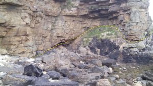
Locations 1 to 4 in the image above refer to the images that follow.
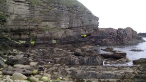
1 Thin, crossbedded bedded sandstone onlap Moine schist, possibly deposited as attached channel sand bars. Local relief on the unconformity is about 2 m.
2. Closer view of the foliated gneiss immediately below the unconformity.3 (left arrow) & 4 (right). Onlapping ORS sandstone – the sag is probably due to compaction between the two gneiss bedrock paleohighs.4. Onlapping sandstone thins against the unconformity. About half way up the bluff there is a stratigraphic discordance within the ORS, where overlying beds dip at shallow angle to the right: two possible explanations: a) the beds fill a compaction depression in the underlying sandstones; or b) the shallow-dipping beds may represent large foreset beds in a channel point bar.
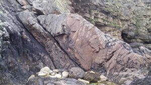
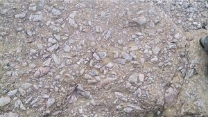
A basal breccia-conglomerate occurs in local paleotopographic lows on the unconformity
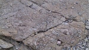
A coarse breccia at the base of the ORS composed almost entirely of fragmented Moine schist. Toe of shoe for scale.A coarse breccia at the base of the ORS composed almost entirely of fragmented Moine schist – foliation is recognizable in some of the larger fragments – up to 20 cm across.Lowermost ORS sandstones contain trough crossbeds, ripples, and channel pebble lags – two examples in the upper third of the image; one immediately below the top overhanging bed, and another about a metre farther down the outcrop.Shallow trough crossbeds in the lowermost ORS; the example here shows left-dipping beds, right half of photo, that probably represent an approximately longitudinal crossbed profile – down current to the left.Straight to wavy crested current ripples in basal ORS. Direction of flow was to top right.Ripples in the basal ORS – direction of flow is ambiguous in this example.
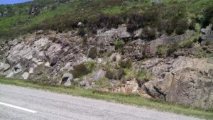
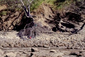
Loch Assynt, northwest Scotland
Lewisian gneisses and migmatites (Archean) are overlain unconformably by Torridonian sandstone (Proterozoic). The roadcut adjacent Loch Assynt is west of the Moine Thrust complex; both rock assemblages are part of the ancient Laurentian continental block. The three images below are from the same general location. At this locality there is subdued paleotopographic relief on the unconformity.
Foliated Lewisian gneiss (foliations dip left about 35° overlain abruptly by well-bedded, reddish Torridonian sandstone. This is a profound unconformity of regional significance.Reddish-grey Torridonian sandstone overlies and onlaps shallow paleotopographic lows on Lewisian gneiss (pale greys).Closer view of the interbedded Torridonian sandstone-shale unconformable on Lewisian gneiss.
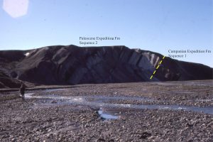
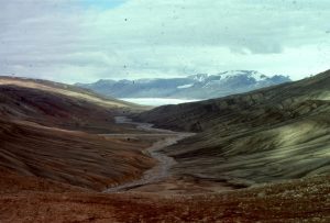
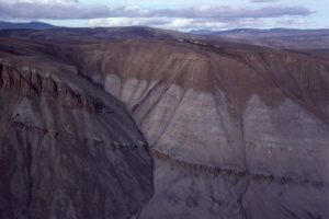
Expedition Formation, Canadian Arctic
The Campanian to Middle Eocene Eureka Sound Group on Ellesmere and Axel Heiberg Islands represents the last gasp of sedimentation in a thermally subsiding Sverdrup Basin. In the central part of the basin, The Expedition Formation contains two third-order stratigraphic sequences separated by a disconformity where most of the Maastrichtian is missing. Along the basin margins Sequence 1 is commonly missing such that Sequence 2 onlaps Paleozoic bedrock.
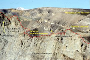
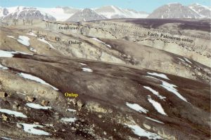
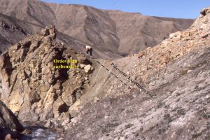
The Campanian-Lower Paleocene unconformity at Hot Weather Creek, Ellesmere Island – the Maastrichtian is missing at this locality. Throughout the basin, the base of the Paleocene is characterised by thick quartz-rich sandstones deposited in estuaries, sandspits and bars.Paleocene-Lower Eocene Sequence 2 (Expedition Formation) onlapping Ordovician limestones on the southeastern margin of Sverdrup Basin. The Highly irregular nature of the unconformity is due to for karst collapse and dissolution of the limestones. The basal Paleocene rocks are mostly paralic facies. Mount Moore, Ellesmere Island.A more expansive view of the Sub-Paleocene unconformity where basal sandstone overlies post-Ordovician karst topography.A well-developed regolith at the Paleocene-Ordovician unconformity, Mt Moore, Ellesmere Island.Panorama of Lower Paleocene basal sandstones (left) in unconformable contact with Ordovician limestones – the contact coincides with the stream bed. Ellesmere Island.Lower Paleocene sandstone (right of the stream) in unconformable contact with Permian sandstone and limestone – the contact is located in the stream. Canon Fiord, Ellesmere Island.
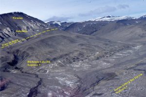
Buchanan Lake Formation, Canadian Arctic
This is the youngest formation in the Eureka Sound Group. Its deposits record inversion and dismembering of Sverdrup Basin by thrust-dominated tectonics during the Middle Eocene. Deposition took place in several foredeeps, that also were involved in the deformation.
Syntectonic, Middle Eocene Buchanan Lake strata disconformably overly Lower-Mid Eocene delta deposits (Iceberg Bay Fm, Sequence 4). Sediment was derived from uplifted Late Paleozoic and Triassic rocks. They were subsequently overthrust by Late Paleozoic anhydrite and Permian mudstone-sandstone. Located north of Whitsunday Bay, Axel Heiberg Island.Syntectonic Buchanan Lake conglomerate (brown hues) overlies unconformably Triassic sandstone – resistant units within the Triassic are diabase dykes. The Eocene conglomerate was derived from an uplifted thrust panel farther west (left). Stang Bay, Axel Heiberg Island.
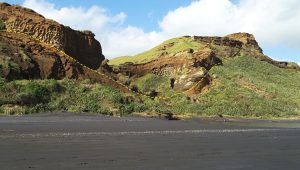
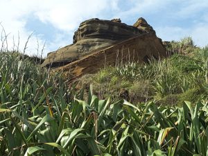
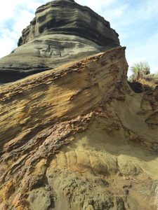
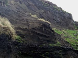
New Zealand Paleogene-Neogene basins
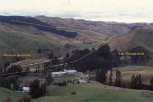
The Late- Miocene – Pleistocene Wanganui Basin occupies a position between the Hikurangi subduction zone and the Late Cretaceous – Miocene rift-passive margin succession comprising Taranaki Basin. Along its eastern margin, Wanganui Basin strata onlap much older greywacke-greenschist basement, shown above at Otupae Station (about 30km SE of Waiouru, along the west flank of the Ruahine Ranges.Marine terraces eroded into Middle Pliocene Tangahoe Mudstone (Wanganui Basin) are exposed on the south Taranaki coast. Here there are excellent examples of shallow, shore platform channels and potholes, filled by pebbly sand of the Late Pleistocene Rapanui Formation. Pollen assemblages indicate that shallow marine-beach and dune deposition took place during interglacial conditions in the late Pleistocene.The Late Eocene-Oligocene Te Kuiti Group (New Zealand) contains cool-water carbonates and associated mudrocks, that accumulated on a broad platform during a period of relative crustal stability. The deposits gradually onlapped eroded Mesozoic greywacke basement (Torlesse-Waipapa terranes), as shown in this quarry, west of Te Kuiti town. The limestone unit is the Otorohanga Limestone. This stratigraphic pinchout is unconformably overlain by Early Miocene, deeper water Mahoenui mudstone.
Waitemata Basin, Auckland, NZ
The Lower Miocene Waitemata Basin extends from greater Auckland into Northland, New Zealand. The fill is dominated by turbidites deposited at bathyal water depths. The basin mainly overlies Mesozoic greywacke. In what is a remarkable contrast in water depth, the basal few metres consists of conglomerate, fossiliferous sandstone and limestone that were deposited in shallow shelf and pocket beach settings. The pre-Miocene surface has considerable paleotopographic relief. Along the Early Miocene coastline this was manifested as greywacke islands, sea cliffs and sea stacks.
The cartoon below shows a rough reconstruction of the Early Miocene environment (drawn more than 30 years ago). Panels a and b show shoreline, beach, subtidal facies, complete with cliff rock-falls and landslides. Panel c depicts the early stages of draping and blanketing by bathyal turbidites and debris flows.
The unconformity in the shore platform below Leigh Institute of Marine Sciences. Intensely deformed Mesozoic greywacke below the red line, is overlain by flat-lying, shallow water calcareous and fossiliferous sandstone. Fossils include abundant barnacles, bivalves (including large oysters), gastropods, solitary corals, bryozoa, calcareous algae (Lithothamnion rhodoliths), foraminifera, and trace fossils.A bouldery breccia on the Early Miocene basin floor, overlying intensely fractured Mesozoic greywacke (at the hammer). The breccia blocks are also greywacke. The breccia is overlain by shallow marine sandstones and limestones.The unconformity at Matheson’s Bay. The steep paleosurface (just left of hammer) is overlain by angular boulders and cobbles of Mesozoic greywacke; it also indicates significant relief on the unconformity. Some boulders contain evidence of pre-Miocene weathering.Paleo-seastacks of greywacke that, following rapid basin subsidence to bathyal depths, were draped by turbidites (brown hues). This sea-stack at the north end of Matheson’s Bay has remnant pholad borings (shallow subtidal and intertidal bivalves that bore into hard rock).Drape folds caused by compaction over greywacke sea-stacks have been exhumed in the modern shore platform. Each rocky “island” that sits proud of the shore platform represents former bedrock highs along the Early Miocene shore, subsequently blanketed by turbidites during basin subsidence. Omana Bay, south Auckland.Panorama of lower Waitemata Basin strata, looking south from Takatu Point. The unconformity on the small island (yellow dashed line) is overlain by boulder conglomerate and well bedded calcareous sandstone.
Kariotahi, Pleistocene dune-barrier bar complex
The west coast of North Island was ‘straightened‘ during the Pleistocene-Holocene by several very large barrier island-bar systems behind which are the North’s harbours and estuaries. The barrier deposits are all siliciclastic shallow marine and subaerial dune sands. The modern harbours are accessed by narrow tidal channels that also feed ebb and flood tidal deltas.
The coastal exposure at Kariotahi beach, west of Auckland city, contains a nice example of an ancient valley cut into older dune sands, that was subsequently filled with a new generation of dune sands and stream deposits, only to be exhumed much later in the Pleistocene. The unconformity between the original valley margin and the infilling dunes is shown below. The unconformity also shows signs of paleosols and weathering associated with fluctuating watertables.
The Pleistocene paleovalley margins (outlined) that eroded shallow coastal marine and dune sands, are overlain by younger dune sands. The modern valley has cut into both of generations of Pleistocene dunes. Kariotahi, west Auckland.Closer views of the Pleistocene valley unconformity. The older (brown) deposits occur below the steeply dipping surface; the younger grey dunes above. The irregular, rust-coloured resistant layers are iron-pans – iron oxides, limonite and goethite, that precipitated during groundwater seepage. Kariotahi, west Auckland. See also the image below.Same location as image above. The dipping surface is the valley margin, cut into Pleistocene dunes. The weathered profile in the lower dune sands contains abundant limonite-goethite hard-pans that developed from water seepage.Typical dune cross bedding in the younger valley fill. The foresets consistently dip right, or landward. The muddy, concave layer near the bottom of the image is thought to have formed in an interdune pond. Kariotahi, west Auckland.