Soils and weathering, the products of physical, chemical, and biological processes, produce a veneer on Earth’s crust that provides sustenance in one form or another for all land-air living creatures, including us. Without soils there would be no food web. No us!
Homo sapiens has learned to use soil to her advantage; growing things to eat, to construct shelter, to decorate. We have learned to utilize soils to the hilt. In fact on a global basis we have taken so little care of them that they have become an endangered species. In our haste to produce food, to irrigate, to scythe through forests, to clear land for some other use, we have damaged soils, in many cases beyond repair. Humanity, in its ignorance, greed and hubris, has managed to seriously compromise the utility of soils – the very things that make life viable.
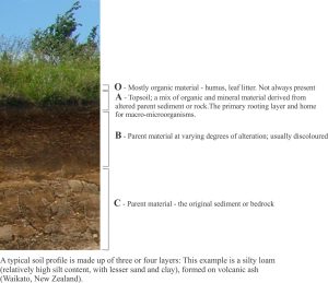
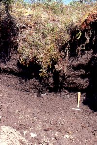
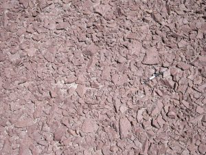
From a structural perspective soils are quite simple; there is topsoil that contains a mix of organic matter derived from plants, macro- and micro-organisms, plus minerals derived primarily from the underlying sediment or rock (parent material). This structure is illustrated in the profile image above.
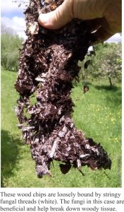
From a biological perspective, soils are complex. Apart from the obvious worms and small critters, there is a burgeoning microflora – fungi and bacteria; and it is the microflora that does most of the work to create a vital growing medium. The microflora breaks down fresh organic matter converting it to humus, and converts nutrients like nitrogen, potassium, phosphorous and many trace elements, into water-soluble forms that plants can metabolize. A vital topsoil requires a healthy microbiota. Soils that are regularly exposed to herbicides, bactericides and fungicides will, over time, become depauperate in useful microflora.
Classification of soils
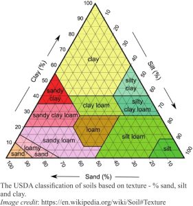
Classification of soils can be complicated. In this Atlas I use a simple textural classification, summarized in the diagram below. It is a US Dept. of Agriculture classification; most other countries use this or slightly modified versions.
The images
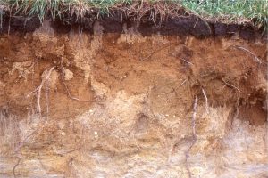
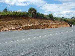
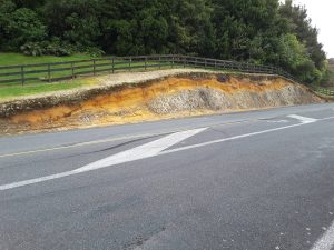
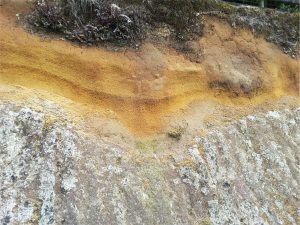
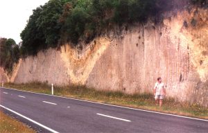
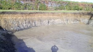
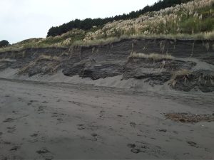
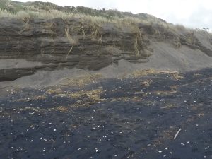
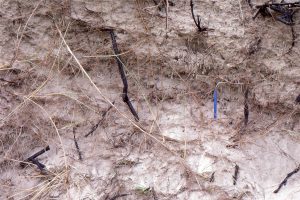
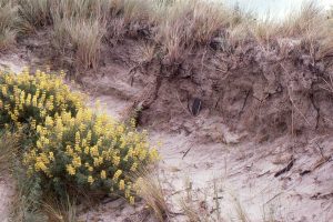
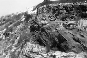
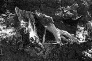
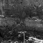
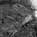
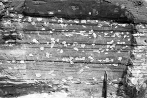
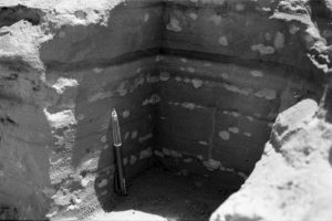
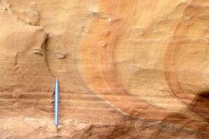
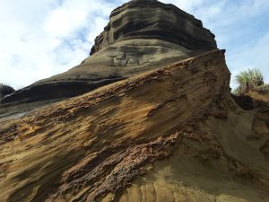
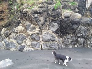
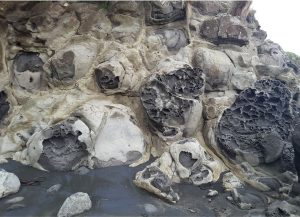
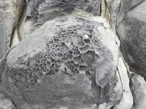
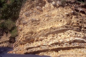
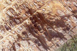
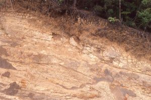
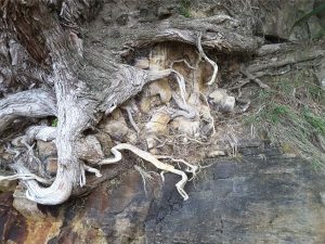
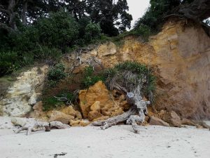
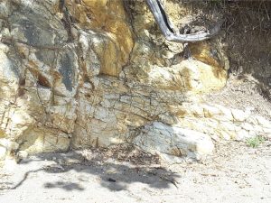
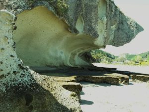
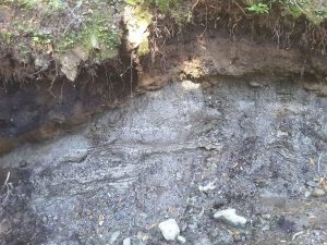
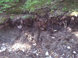
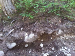
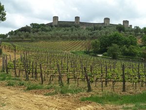
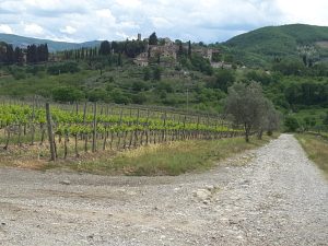
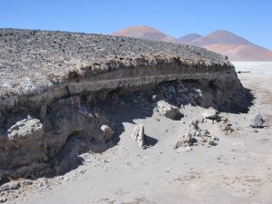
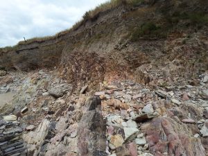
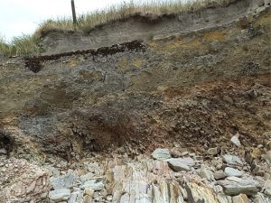
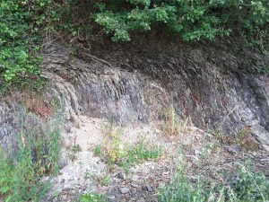
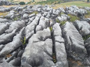
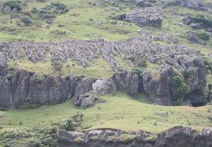
Silt-sand loams developed on Late Pleistocene fluvial pebbly volcaniclastics (Hinuera Formation, Waikato, NZ). The transition from modified sediment (orange-brown) to parent material (pale brown) is irregular. The base of the topsoil (organic) layer is quite abrupt and may have been altered by cultivation.A modest organic layer developed on multiple ash beds; remnants of an older soil (paleosol) is located above the whitish band of ash (Rotowaro, Waikato, NZ). Most of the loamy soils in this region are developed on volcanic ash beds.Thin (pumice) loam on orange-brown airfall ash that overlies partly welded Mamauku Ignimbrite (about 220,000 years old; the orange ash layers may be co-ignimbrite). Iron oxide staining indicates groundwater seepage and mineral alteration. Mamaku, north of Rotorua N.Z.Close view of the soil profile on Mamaku Ignimbrite and airfall ash (bedded orange-brown; see image above). The organic layer is only a few cm thick. Oturoa Road, north of Rotorua, NZThree sets of small V-shaped paleovalleys and intervening ridges cut into welded Mamaku Ignimbrite (about 220,000 years old), draped by at least three ash fall deposits and thin paleosols (paleosols). The entire outcrop is overlain and truncated by more recent soil and modern vegetation. North of Rotorua, NZThin sandy loam topsoil and iron-stained layer on Holocene coastal plain gravels. The upper part of the topsoil has been disturbed by cultivation. The normal position of the watertable is at the transition to gray gravel. Kaiua, Thames coast east of Auckland, NZ.Eroded section of coastal dunes, Raglan, N.Z.. Spinifex roots penetrate up to 2m into the sand. Soils here are very low in organic matter, almost 100% sand with high permeability and little capacity for water retention.Eroded section of coastal dunes, Raglan, N.Z.. Spinifex roots penetrate up to 2m into the sand. Soils here are very low in organic matter, almost 100% sand with high permeability and little capacity for water retention. The dark-coloured sand here is mostly magnetite, ilmenite and amphiboles.Coastal dune root systems (Spinifex and Lupin). Much of the organic matter is oxidized rapidly. Dune instability means that topsoil formation is meagre.Coastal dune root systems (Spinifex and Lupin). Much of the organic matter is oxidized rapidly. Dune instability means that topsoil formation is meagre.Cross-bedded dune sands overlain by woody peat (O layer) about 75 cm thick, and 12,000 to 20,000 years old. Tree stumps protrude from the peat surface. The B layer here is sand enriched in iron oxides precipitated by ancient fluctuating water tables. Great Exhibition Bay, northern NZCoastal tree and shrub root systems preserved in the 12,000 – 20,000 year old peat shown above. The peat contains twigs and preserved leaves of typical New Zealand podocarps. Knife is 20 cm long.Part of the same fossil peat shown above with upper and lower divisions marked by polygonal fractures and crude layering of woody peat, and a middle laminated layer that contains more siliciclastic mud. The uppermost portion has been altered by more recent vegetation. Spade handle is 60 cm long.A 1.4 m thick peat that caps a marine-cut terrace 20 m above present sea level. The peat contains roots and fallen logs, and abundant podocarp leaves. Great Exhibition Bay, northernmost NZ. The peats along this part of the coast preserve the remains of verdant coastal forests to at least 30,000 years BP.Semiconsolidated, cross-bedded Pleistocene dune sands beneath a peat. Here, the parent sands have reduction spots derived from leaching of iron oxides. Great Exhibition Bay, northern NZA 3D cut section of reduction spots common in the Pleistocene dune sands exposed along Great Exhibition Bay, northern NZ. The spots tend to be concentrated and elongated along dune laminae.Liesegang rings are a common manifestation of shallow weathering in permeable sandstone. The ring-like patterns form as iron oxides precipitate in concert with migrating groundwater. Precipitation is primarily controlled by Ferric ion saturation and diffusion. In places the ring patterns can mimic bedding and crossbedding. Mokau Sandstone, north Taranaki, NZRemnants of a soil formed over stabilized Pleistocene dune sands. The abrupt steep-dipping contact with a younger set of dune deposits is delineated by resistant limonite-goethite hardpans that precipitate from fluctuating groundwater tables (alternating vadose to saturated). Precipitation is controlled by permeability anisotropy, where the highest permeability generally parallels primary dune lamination.Spheroidal weathering of basalt flows associated with the Late Pliocene Karioi Volcano. Spheroids are bound by columnar joints from the original lava flow. Closer inspection reveals intricate honeycomb weathering patterns.Exfoliation of spheroidally weathered rock rinds in Pliocene Basalt, NZ. Large honeycomb weathered pockets occur in several spheroids.Honeycomb weathering of spheroids on basalt flows exposed to continuous seawater spray. Late Pliocene Karioi Volcano, Raglan, NZ. Spheroids are bound by columnar joints from the original flow.A mix of spheroidal weathering and iron oxide precipitation in indurated Triassic sandstone-argillite, where alteration patterns are strongly influenced by bedding (left-dipping) and fractures (mostly normal to bedding); Kiritehere, NZCloser view of weathering patterns in Triassic well bedded sandstone-argillite (see image above). Alteration is clearly controlled by both bedding and fractures normal to bedding.Profile of muddy loam developed on weathered turbidite sandstone-mudstone. Alteration of the parent rock is several metres deep, exacerbated by mutiple closely-spaced fractures and joints. Near Wellsford, north Auckland NZ.Tree roots that penetrate and grow in rock fractures and joints are capable of eventually dislodging large blocks and contribute a significant cause of cliff instability and erosion. Here is an example where blocks of jointed flow-banded rhyolite are being dislodged. Hahei, New Zealand.Localized hydrothermal alteration of flow-banded rhyolite (orange iron-enriched zone) has weakened the flow-banded rhyolite bedrock. Collapse of the cliff is exacerbated by soil formation and tree roots. Hahei, New Zealand.Mineral replacement and oxidation of rhyolite along fractures that act as conduits for groundwater seepage and mass transfer of dissolved solids.Coastal exposure of partially welded Ignimbrite sculpted by wave, wind and rain. Flaxmill Bay (south of Whitianga), New ZealandSilty clay loam developed on Carboniferous shale, Cliffs of Moher, west IrelandClay loam developed on glaciolacustrine clays, Mt. Garibaldi, British Columbia.Discontinuous, gravelly clay loams and clays developed on steep alpine mountain slopes, Mt. Garibaldi, British Columbia. The organic layer is either very thin or absent.Gravelly clay loams and clays developed on steep alpine mountain slopes, Same location as image above. Mt. Garibaldi, British Columbia. The organic layer is either very thin or absent.Typical stoney silt-clay loams of Tuscany, surrounding the 12th century fortification of Monteriggioni.; the foundation of Chianti Classico and olives. Bedrock parent material represented by the gravel component consists of Cretaceous-Paleogene marls, sandstones and shales.Typical stoney silt-clay loams of Tuscany, surrounding the 12th-15th century fortification of Montefioralle.; the the principle region of Chianti Classico and olives. Bedrock parent material represented by the gravel component consists of Cretaceous-Paleogene marls, sandstones and shales.Arctic soils riven with permafrost. Left: Typical patterned ground developed on Arctic permafrost. The hummocks are generally less than a metre wide; their tops are vegetated. This ground is difficult to walk on.Frozen muddy loam riven with permafrost undergoing summer melt. Melting releases organic carbon, carbon dioxide and methane. Willow Creek, north Yukon.Arid soils in the Chilean Atacama and mountainous Altiplano commonly lack any organic component. Here a section through the exposed surface of an inactive alluvial fan contains a mix of stony material, sand, silt and mud. Calcite cements occur locally, and gypsum-halite cements are present where the fan lobes encroach local salars.Desert varnish, a common feature of prolonged, arid climate weathering. The varnish consists of silica, iron and manganese that are leached slowly from the original rock, and re-precipitated as oxides.Soil creep in sub-vertical shale, east Kansas, beneath a stony clay loam.Old Red Sandstone bedrock extends into the low cliff where it is broken and gradually incorporated into gravelly colluvium by soil creep. The overlying thin sandy loam is formed predominantly on wind-blown sand. Red Strand, south Ireland. The top surface slopes towards the local beach.Closer view of the gravelly colluvium and thin sandy loam developed on Old Red Sandstone, Red Strand, south Ireland. The lower part of the colluvium contains bedrock deformed by gradual downslope creep.Soil creep in vertically dipping Devonian shale acts to incorporate shale slivers into the overlying clay-silt loam. Kinsale, south Ireland.Karst, common weathered landforms in carbonate rocks: Clints (blocks) and grykes (jointed gaps or fissures) formed by dissolution of carbonate along fractures in Carboniferous limestone, Burrens, Ireland.Pinnacle dissolution karst structures in jointed Oligocene – Early Miocene limestone, Takaka, NZ (Image by Kyle Bland, GNS).