Texture in a rock describes the relationship of its components – grains, minerals, other chunks of rock – to one another. In detrital sediments and sedimentary rocks, a distinction is made between clasts that form the framework (silt, sand, grit, pebble, cobble, boulder), and detrital sediment that is the matrix – matrix resides in the spaces between grains and usually consists of very fine-grained sediment, such as clays and silt. Detailed description of the matrix usually requires a microscope.
We can describe the framework in terms of the size (sand, cobble etc.) and shape of individual clasts (spherical, oblate, angular versus rounded), the proportions of different clast sizes (e.g. sorting), and the proportion of framework to matrix. These are all useful descriptors of a sediment, but they can also provide valuable information on depositional processes, such as:
the degree of sediment reworking during transport (e.g. beach versus glacial diamictite),
depositional energy (e.g. river channel versus floodplain, beach versus estuary),
the removal, or winnowing of lighter, or hydraulically more buoyant mineral grains (e.g. micas), or
removal of mechanically less stable grains or minerals – for example quartz is mechanically more stable than feldspar because the latter usually has good cleavage.
Sedimentary fabric refers to detrital components that impart some kind of directionality to rock and sediment. It can be thought of as a vector, that has both magnitude (size, shape) and direction (texture only has qualities like size, shape, proportion and so on). Thus, the alignment of clasts or fossils imparts a fabric (e.g. pebble imbrication in a channel, or current-aligned fossils).
Together, texture and fabric are important additions to a geologists toolbox, for description and interpretation.
The Atlas, as are all blogs, is a publication. If you use the images, please acknowledge their source (it is the polite, and professional thing to do).
Here are some related posts that you might find useful
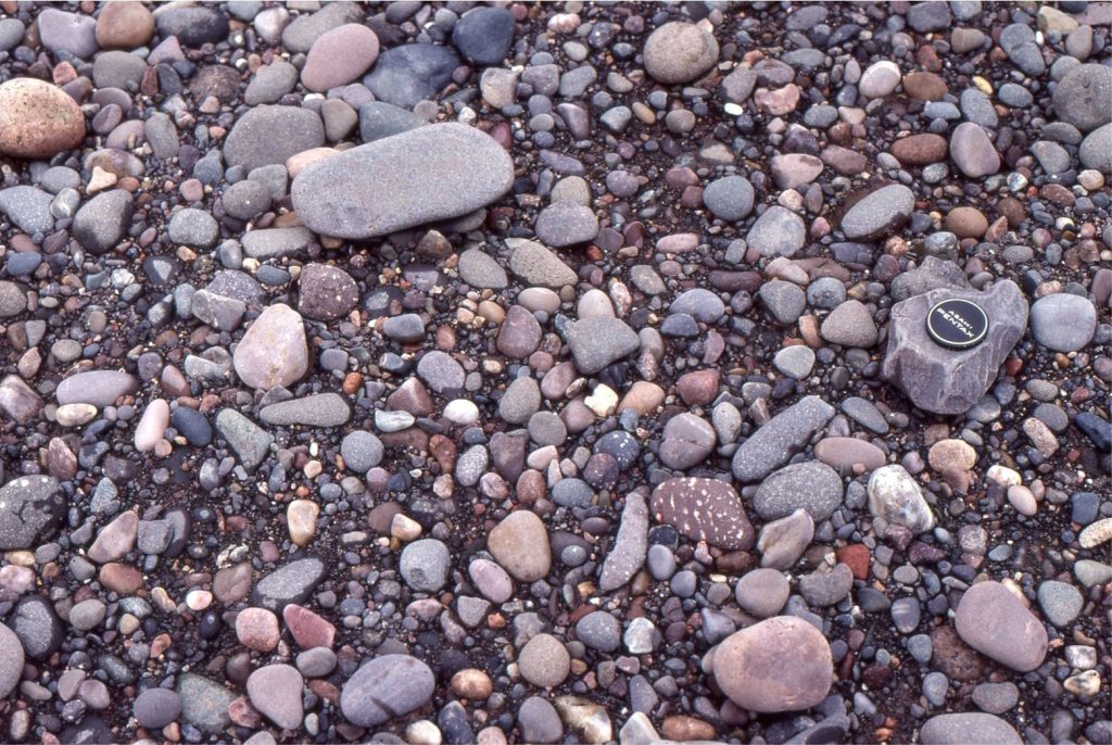
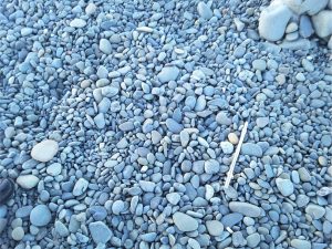
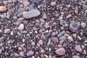
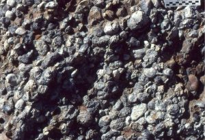
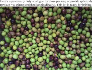
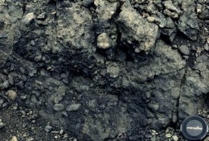
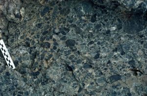
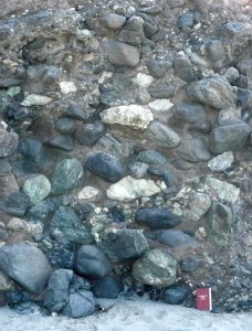
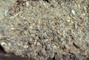
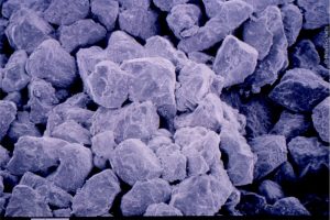
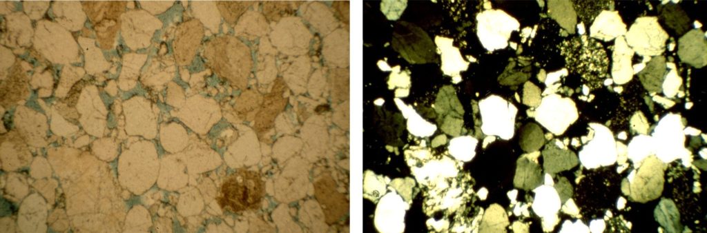
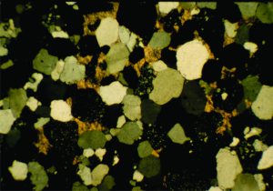
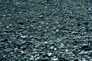
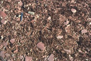
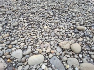
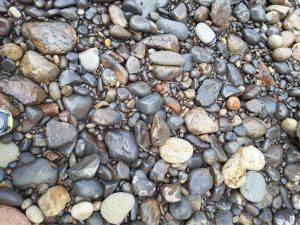
Beach gravels at Haumoana, NZ; typically clast-supported frameworks of well rounded, oblate to platey pebbles and cobbles. The texture and lack of fine matrix are in keeping with the high wave energy along this coast.Beach gravels along Fundy Bay, Nova Scotia; typically clast-supported frameworks of well rounded, oblate to platey pebbles and cobbles. The texture and lack of fine matrix are in keeping with the high wave energy along this coast.Beach storm ridge shell accumulations, clast (shell) supported. The shells are predominantly gastropods, including abundant Struthiolaria. There is no obvious preferred orientation of shells and shell fragments. Mangawhai Heads, NZExhumed surface of a Jurassic fluvial deposit. Pebbles of radiolarian chert are all well rounded, and most participate in a clast-supported framework. Rounding of the pebbles must have taken place in a shallower water environment, probably fluvial. Scale in centimetres. Bowser Basin, northern British Columbia.Here is an analogy for packing of well rounded, spherical to subspherical clasts, as in the chert conglomerate imaged above.Contrasting debris flow textures. This image – matrix-supported clasts of radiolarian chert and mudstone rip-ups – this was a very muddy, cohesive debris flow. Image below – mixed last-supported and matrix-supported clasts in a less cohesive, more fluid debris flow. Bowser Basin, northern British Columbia.See image caption aboveFour stacked. bouldery debris flows, with mixed clast- and matrix-supported frameworks; flow units are delineated by fairly abrupt changes in grain size. The matrix is mostly mud. Framework grain size range is from boulder to sand. Clast compositions include metamorphic and intrusive igneous rocks. Dana Point, California.Lower Miocene volcaniclastic debris flow, mostly matrix-supported but pockets of clast-supported frameworks. There is also a crude clast size grading. The largest clasts are about 30 cm wide. Waitakere Volcanic arc, west Auckland.Scanning electron microscope image of a moderately well-sorted sandstone, Ellerslie Fm, Alberta. Sand grains show varying degrees of depositional rounding. The fuzzy surface of most grains is caused by incipient diagenetic clays (illite-kaolinite), i.e. clays formed by chemical reactions after deposition. This rock has excellent porosity and permeability. The image width spans 3mm.Thin section micrographs of a lithic sandstone (arenite). Left: plane polarized light, showing individual grain shapes (subangular to moderately rounded) and intergrain contacts. The blue areas are pore spaces filled with blue resin. Right: Crossed nicols, showing quartz in various stages of extinction, lithic grains (speckled), and minor potassium feldspar. Ellerslie Fm, Alberta. Most grains here are about 0.2 – 0.3mm across.Thin section micrograph, under crossed nicols of a calcite-cemented, clast-supported, lithic-quartz sandstone, Ellerslie Fm, Alberta. The calcite has a yellow-orange colour. Most grains here are about 0.2 – 0.3mm across.
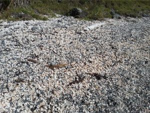
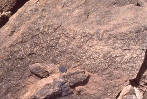
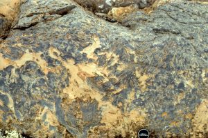
The fusulinid foraminifera incorporated into these Permian sediments have all been aligned approximately parallel to the local paleocurrents (consistent with directions indicated by crossbedded calcarenites). South Bay, Ellesmere Island. Coin is 24 mm diameter.Modern river gravels containing abundant platy rock fragments that are aligned by the prevailing currents. The imbrication here indicates flow to the right – dips on the platy clasts dip upstream.Parting lineationin laminated sandstone forms when the long axes of sand grains, in layers a few grains thick, are aligned parallel to current flow directions. The streakiness, or lines form when sandstone splits along the laminae. They are thought to form during upper flow-regime plane bed flow (high energy flow). Paleoflow in this example was either to the right or left; a decision as to which direction can only be determined from unidirectional structures.Stone rosettes form on beaches where there is a plentiful supply of platy rock fragments – in this case much older shale. The flat clasts are turned edgewise by wave action, and commonly are organised into crude radiating or stacked patterns (also called edgewise conglomerate). Similar structures can form from bivalve shells. On some beaches they form extensive pavements. Somewhat similar structures have been reported from periglacial regions.An example of ancient stone rosettes, or edgewise conglomerate forming extensive pavements on a Proterozoic beach (about 2 billion years old). In this example (Mavor Fm., Belcher Islands, Hudson Bay), the thin slabs consist of dolomitized lutite crusts that formed in a supratidal flat and subsequently were ripped up by storm waves.
Here is a paper on these examples: Ricketts, B.D. and Donaldson, J.A. 1979: Stone rosettes as indicators of ancient shorelines: examples from the Precambrian Belcher Group, Northwest Territories; Canadian Journal of Earth Sciences, v. 16, p. 1187-1891
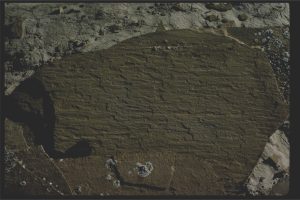
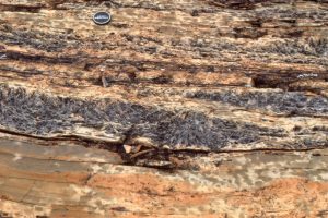
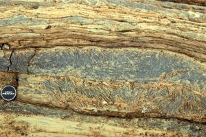
Two cutaway views normal to bedding of ancient Proterozoic stone rosette beach pavements (see also image below). The edgewise stacking of platy dololutite crusts is readily apparent. Three successive pavements are preserved here. A bedding view of the same structures is shown above. Mavor Fm, Belcher Islands, Hudson bay.Stacked edgewise conglomerate pavements, overlain by wavy and lenticular bedded dolomitic grainstone and interbedded dololutite. Mavor Fm, Belcher Islands, Hudson bay.Beach pavement of close-fitting, well rounded cobbles and pebbles (andesite, dacite), near Little Bay, Coromandel, NZ Close-fitting, clast-supported, poorly sorted, subangular to well rounded cobbles and sand on a beach, Little Bay CoromandelAngular andesite boulders in fine sand present a broadly bimodal grain-size population on a moderately high energy beach, Little Bay, Coromandel, NZ
1 thought on “Atlas of sedimentary textures and fabrics”
Bruna
Fantastic work! Thank you so much for organizing this!


1 thought on “Atlas of sedimentary textures and fabrics”
Fantastic work! Thank you so much for organizing this!