Allochthonous terranes, suspect terranes, exotic terranes.
In 1972 James Helwig introduced the concept of orogenic collage, wherein orogenic belts were representative not of a unified series of tectonic events, but are a collection of disparate terranes that are structurally discordant one with the other (Helwig, 1974). Each terrane is stratigraphically and structurally distinct from its neighbours. Each terrane has a distinct geological history that precedes its amalgamation to other terranes, but linkages to other terranes are established by crustal- and lithosphere-scale plate tectonic processes, principally subduction, obduction, and strike-slip transform displacement. Thus, terranes have pre- and post-accretion histories. The associated sedimentary basins provide the geological history of all these events.
The twin concepts of orogenic collages and allochthonous terranes are central to our present understanding of mountain building. Many of the important concepts and terminology were established in the 1970s and 80s – most have stood the test of time and scientific critique (Monger et al., 1972; Coney et al., 1980; Jones et al., 1983; Coney, 1989.
The following notes describe the main criteria for identifying terranes, the timing of terrane accretion (to other terranes or stable craton), from whence they came, and how far they have traveled.
Suspect, Exotic, Allochthonous, Tectonostratigraphic terranes
- Because of their oddness, terranes (not terrains) are often referred to as exotic or suspect. All of them are allochthonous, some having traveled many 1000s of kilometres. The term tectonostratigraphic terrane refers to their unique stratigraphic and structural histories.
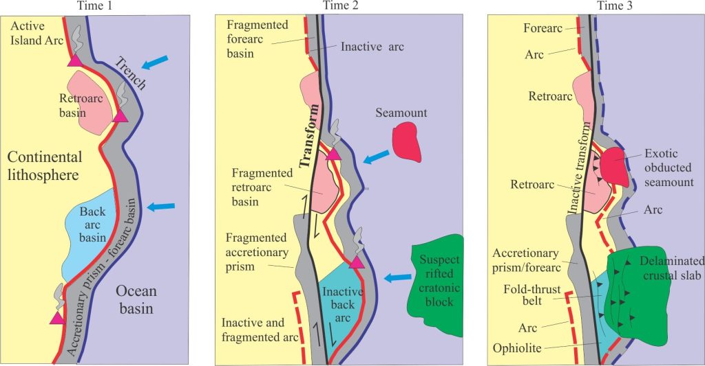
- Terranes may be complete lithospheric entities, or slivers of crust scraped off or delaminated during accretion. Accretionary prisms are good examples of the latter, where the upper portion of oceanic crust is scraped off during subduction (the remainder goes down the subduction zone).
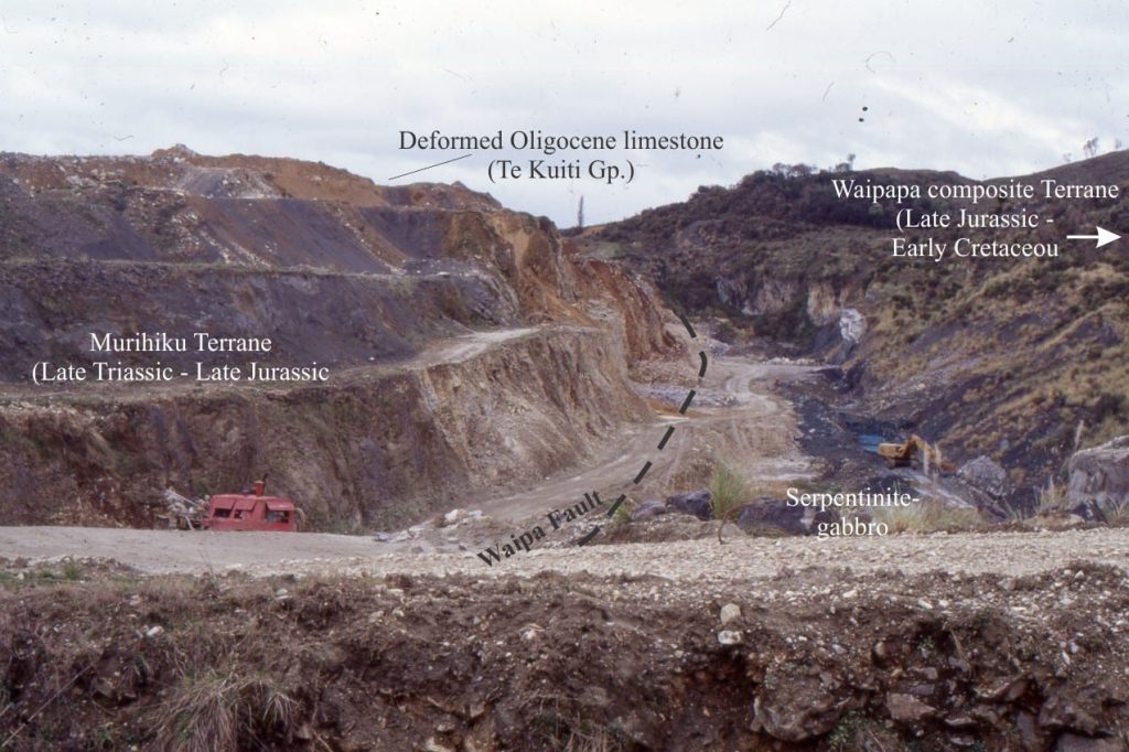
- Terrane candidates include rifted continents, fragments of oceanic crust (including seamounts and oceanic plateaus), and island arcs. Ophiolites are, perhaps, the quintessential discordant terrane – long recognised in the European Alps (pre-plate tectonics) as ‘odd rocks’ – assemblages of ultramafic rocks, sheeted dykes, basaltic pillow lava, ribbon chert and pelagic shale, tectonically juxtaposed against shallow water miogeoclinal successions. By the early 1970s it was generally agreed that ophiolites were remnants of oceanic crust, and in many cases were the only evidence of former ocean basins.
- Amalgamation, or docking of a terrane to autochthonous cratons or other terranes involves accretion via plate convergence or strike-slip displacement. Plate convergence inevitably involves spreading and subduction of oceanic lithosphere.
- Two or more terranes may dock en route to their destination. These amalgamations are called composite or superterranes.
- Sedimentary basins: Inboard basins are those on the leading edge of an advancing terrane; the basins may overly the terrane, be a part of an intervening ocean, or configured as forearc or foreland basins (the latter tied to fold-thrust belts that form during plate convergence). Terrane displacement by strike-slip faulting may produce inboard pull-apart basins. Outboard basins are located on the trailing edge of a terrane. Inboard basins will potentially provide most of the relevant information on the timing of docking and its associated deformation.
Criteria for terrane identification
- Terranes are invariably bound by faults or zones of deformation. Deformation during docking will affect both the incoming terrane and the autochthon, and potentially crosscut or overprint pre-existing structural fabrics.
- They tend to have stratigraphy, structure, and radiometric ages that are incompatible with other terranes or the autochthon.

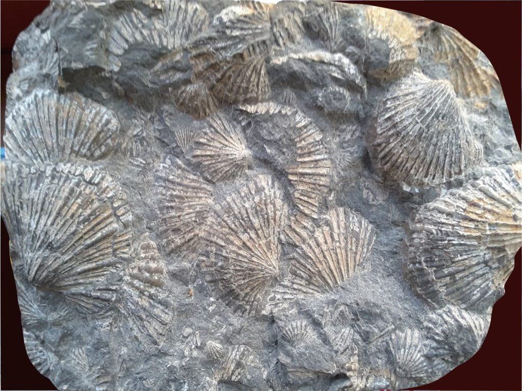
- Assemblages of fossils may be incompatible with those in the autochthon. For example, the cosmopolitan bivalve Monotis, distributed globally but restricted to the latest Triassic, is found in autochthonous strata (North American continent) as far north as Nevada, but about 1000 km farther north in west coast British Columbia and Alaskan terranes (Tozer et al. 1991).

- Radiometric dates of stable sedimentary grains such as zoned zircon commonly span a range of ages that represent the original magmatism plus later events such as metamorphism, uplift, and sedimentary reworking. Suites of ages from a terrane will commonly mismatch those from adjacent terranes or the autochthon (Gehrels, 2014). For example, if sedimentary zircons lack Precambrian ages, then it is unlikely that they were derived from basement rocks in an adjoining craton.
- There may be a mismatch between the paleomagnetic poles measured in volcanic and fine-grained sedimentary rocks from a terrane, compared with the paleopoles determined for similar aged rocks elsewhere. The discrepancies provide a means of calculating possible distances of terrane dislocation and/or rotation.
Timing of terrane docking
Establishing the timing of terrane docking is one of the more difficult tasks. If the approach of a terrane (lithospheric or crustal block), is orthogonal the docking can be viewed as an event with a relatively narrow time span. However, if terrane approach is oblique then docking is diachronous and protracted. Criteria that help constrain the age limits are:
- Pluton stitching; magmatic intrusions that extend across a terrane fault boundary provide upper age limits for accretion.
- Overlap assemblages; terrain uplifted during accretion will shed sediment across the terrane boundary. In this case, unroofing and sedimentation will signal the end (or close to it) of the deformation associated with terrane accretion. The downside to overlap assemblages is that they also cover the terrane boundary. The term successor basin (Eisbacher, 1974; Ingersoll, 2012) is, for all practical purposes, synonymous.
- Establishing the beginning of terrane docking is more difficult. There may be clues in preserved inboard sedimentary basins. For example, forearc basins, or basins that overlie the inboard margin of terranes may experience an influx of sediment, changes in sediment composition resulting from uplift, or unroofing that exposes deeper levels of existing sediment sources. There may also be changes in the locus of sediment dispersal in these basins.
- The above criteria are pretty broad-brush; they also rely on dating the changes in basin dynamics. Zircon geochronology can assist here, where the upper age limit in a suite of (sedimentary) zircon dates may be close to or herald a docking event.
The Canadian Cordillera
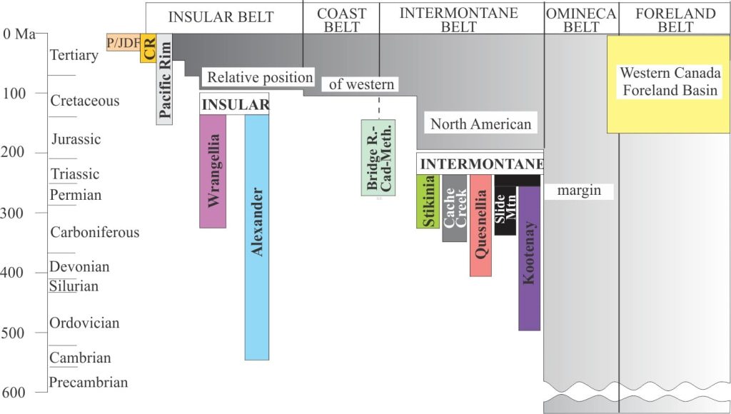
The western North American Cordilleran orogen is a collage of more than 200 terranes and superterranes (Monger, 1989; Ingersoll, 2019), ranging from large lithospheric blocks to skinny slivers of delaminated crust. Decades of regional mapping in the Canadian sector indicates that the Cordilleran margin has grown westward many 100s of kilometres from the edge of the stable craton, the product of terrane accretion over the last 180-200 million years. Most of the terranes and associated sedimentary basins are contained in two superterranes; Intermontane and Insular superterranes. [In addition to the references cited above, see Ricketts 2019 for a general synthesis of Cordilleran basins].

The Intermontane composite terrane contains 5 major terranes. The timing of their accretion into a single superterrane and its subsequent docking with North America is still debated, but it generally spans the period Early to Middle Jurassic. Farther east, this event records the beginning of the Western Canada Fold-Thrust belt and a significant pulse of sediment (the Kootenay-Fernie clastic wedge) shed to the adjacent foreland basin .

Insular superterrane consists almost entirely of two large terranes, Alexander and Wrangellia, that were amalgamated prior to docking with the western margin of Intermontane superterrane during the middle Cretaceous. The effects of superterrane docking were manifested farther east as renewed folding and thrusting, and development of the Blairmore (mid Cretaceous) and Belly River-Paskapoo (Late Cretaceous) clastic wedges in the Western Canada foreland basin (Stockmal et al, 1992; see the synthesis by Miall and Catuneanu, 2019). The linkages between Western Canada fold-thrust belt and superterrane docking are a good indication of the magnitude and extent of strain partitioning during terrane accretion.
‘Baja BC’
That the western Cordillera is a college of disparate terranes is no longer debated. However, the issue of whence the terranes came and how far they traveled is very much up for discussion. There is no better illustration of the disparity among competing hypotheses relating to terrane trajectory than the Baja BC debate, that concerns the origins of Insular and Intermontane superterranes; see Butler et al., 2001 (PDF); Gabrielse et al., 2006 (PDF); and Hildebrand, 2015 (PDF), for good reviews.
One school of thought posits travel from as far away as Mexico (4000 km), whereas another group of hypotheses contends distances were less than 1000 km. The debate hinges on paleomagnetic, paleontological and zircon geochronology data sets that not only conflict with each other, but in some cases are contradictory within their own data group. Some examples include:
- Comparable, low latitude Permian fusulinids and Triassic coral faunas on the craton and terranes indicate large separations. However, mid- to high-latitude, upper Mesozoic radiolaria and molluscan faunas indicate minimal northward superterrane displacement.
- Paleomagnetic data for Baja BC indicate about 3000 km northward displacement, but corrections for structural tilting of crustal blocks reduces these distances to less than 1000 km.
- Zircon ages of possible source rocks for sedimentary basins on Insular superterrane have on the one hand been interpreted as locally derived, and on the other derived from source rocks in north Mexico, supporting the far-traveled school.
Despite nearly 5 decades of examination and re-examination, disagreement persists and a consensual hypothesis remains elusive.
Other posts in this series
Sedimentary basins: Regions of prolonged subsidence
The rheology of the lithosphere
Isostasy: A lithospheric balancing act
The thermal structure of the lithosphere
Classification of sedimentary basins
Stretching the lithosphere: Rift basins
Nascent, conjugate passive margins
Thrust faults: Some common terminology
Basins formed by lithospheric flexure
Basins formed by strike-slip tectonics
Source to sink: Sediment routing systems
Geohistory 1: Accounting for basin subsidence
Geohistory 2: Backstripping tectonic subsidence


