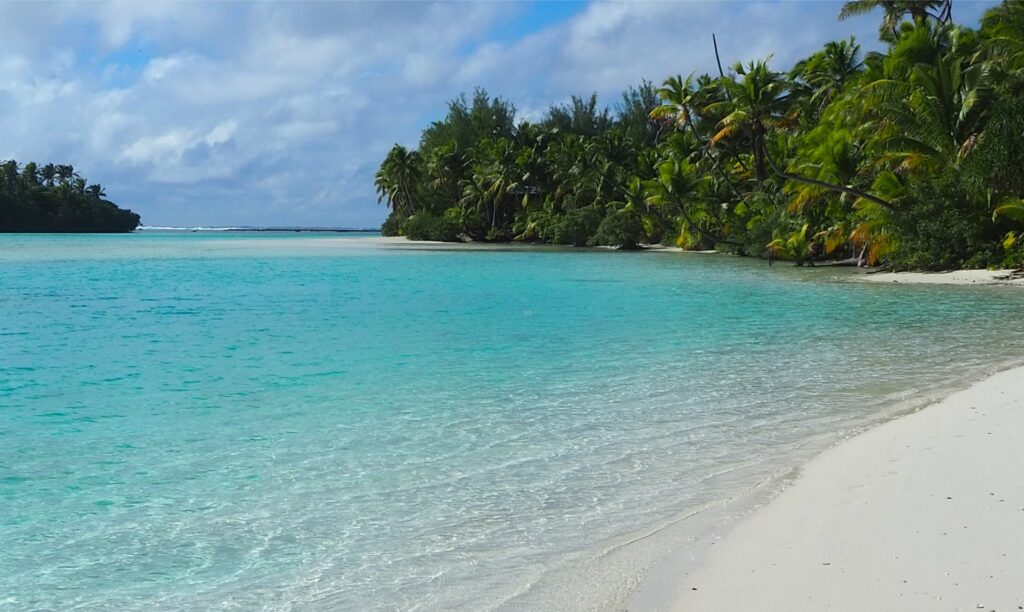
A look at the modern settings for carbonate platform deposits on Aitutaki volcanic island and lagoon.
Isolated carbonate platforms are one of the fundamental tectono-stratigraphic settings in the carbonate rock record. We tend to think of Great Bahama Bank as the quintessential modern platform analogue, but atolls that form over seamounts and volcanic islands are also part of this important carbonate milieu. Both Pacific and Indian oceans possess a rich array of atolls, near atolls, and reef-rimmed volcanic islands across their tropical latitudes. Aitutaki (Cook Islands) is a southern hemisphere example that, apart from being quite beautiful, is accessible; its lagoonal waters are easy to navigate and ideal for snorkeling.
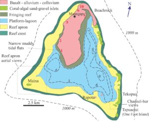
Aitutaki is referred to as a near atoll because it hasn’t quite matured to full atoll status – about 15% of the total area is exposed volcanic bedrock, most of this in a single island. The main lagoon extends south and east of the main island. The lagoon and its peripheral islands, sand bars, and coral-algal reef are the shallow expression of an isolated, mid-ocean carbonate platform. Alkali basalts in the exposed part of the volcanic edifice are dated at 1.382 to 1.941 million years (K-Ar and 39Ar/40Ar ages) although one breccia sample from the volcaniclastic deposits dates at 9.39 Ma – Rose and Koppers, 2019; OA), which means the platform is probably as old as Early Pleistocene and possibly latest Miocene.
Sedimentary facies associations
Five sedimentary facies associations have been identified by Summerhayes (1971, PDF) and Rankey et al., (2011). Facies boundaries are more or less parallel to the lagoon isobaths; the boundaries also correspond to distinct geomorphic domains. Sedimentation occurs within a backdrop of micro-tides (0.12 – 0.49 m), and east to southeasterly trade winds. Wave climate in the lagoon is modest because ocean swells are attenuated by the main reef. Bottom currents hover around 10cm/s in fair weather.
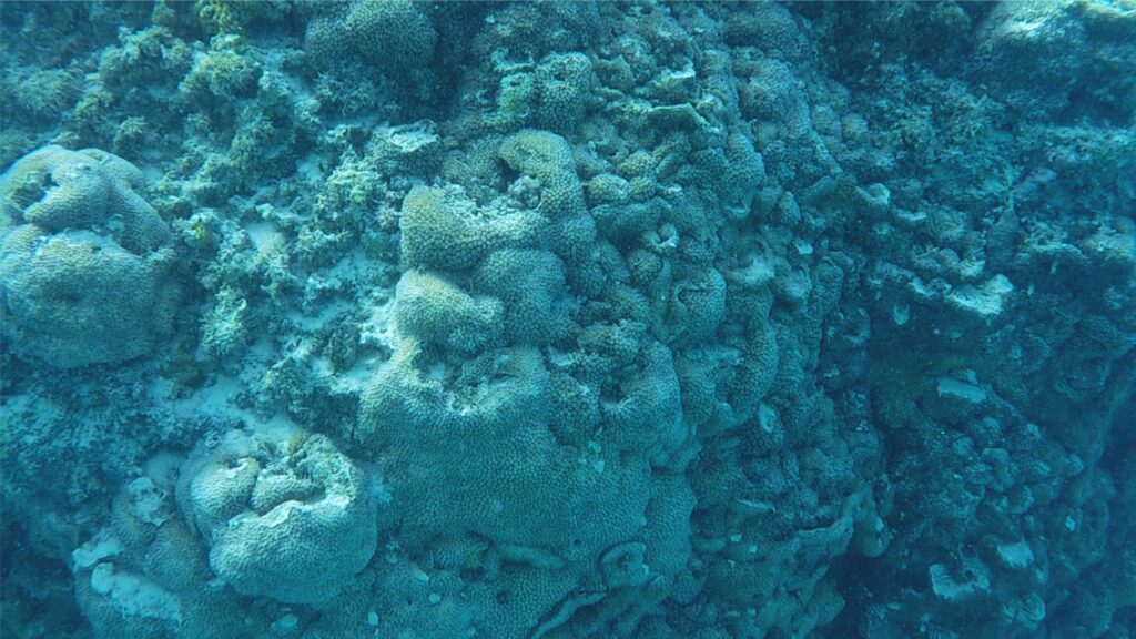
Coral reef
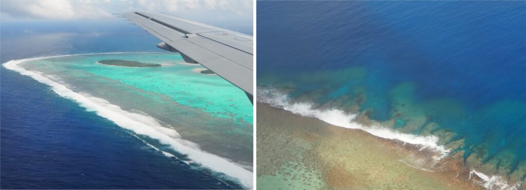
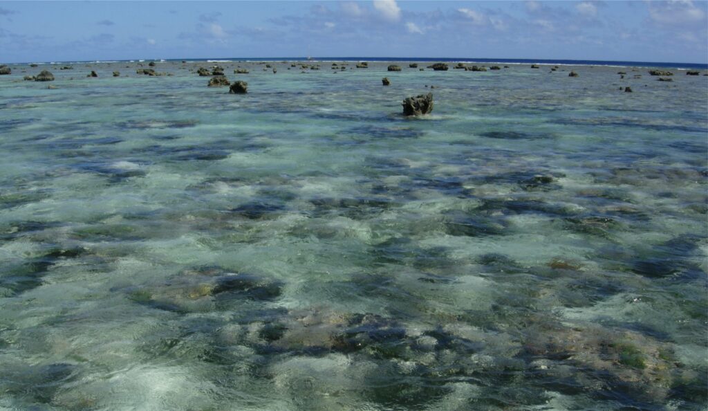
The reef crest extends from the forereef wave breaker zone (not examined) 50-100 m toward the lagoon. The crest surface is broken by closely spaced spur and groove structures that originate in the upper forereef (see the photo below) and are oriented approximately at right angles to the reef front. Spur spacing is a few 10s of metres. Grooves are commonly floored by reef-derived gravel – some of this gravel is moved onto the reef apron during storms.
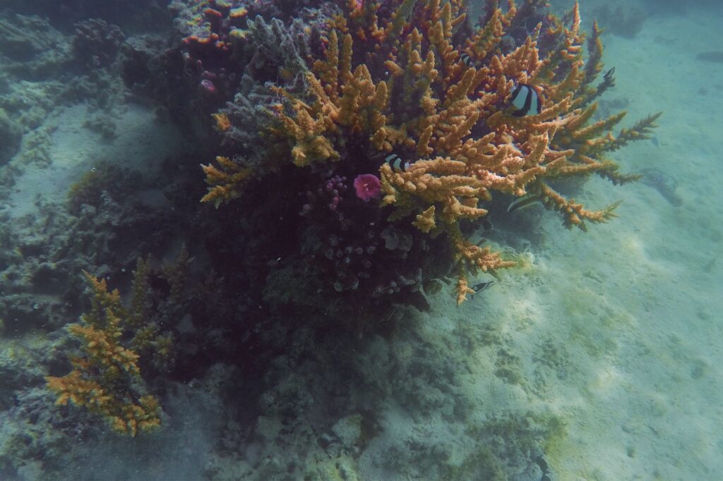
Common coral species include Porites, Acropora, and the platy table coral Astreopora sp. Encrusting, nodular, and branched calcareous algae (e.g., Lithophyllum) are important contributors to the reef framework. Brown and green algae, including the calcareous green algal sediment-producer Halimeda, also contribute to the reef ecosystem (Rongo et al., 2013, PDF).
Reef apron
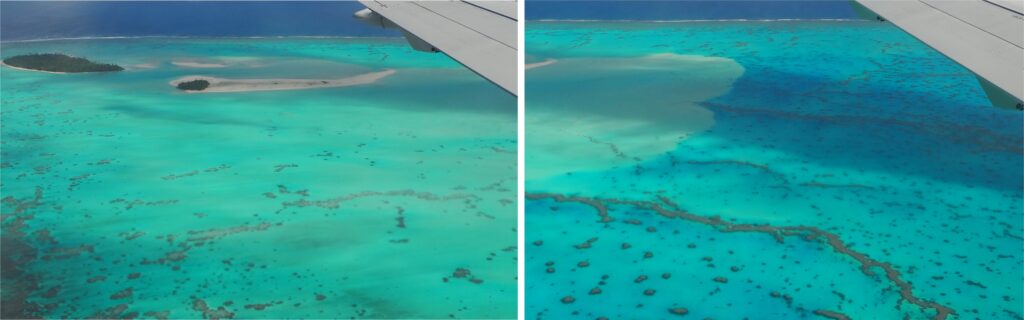
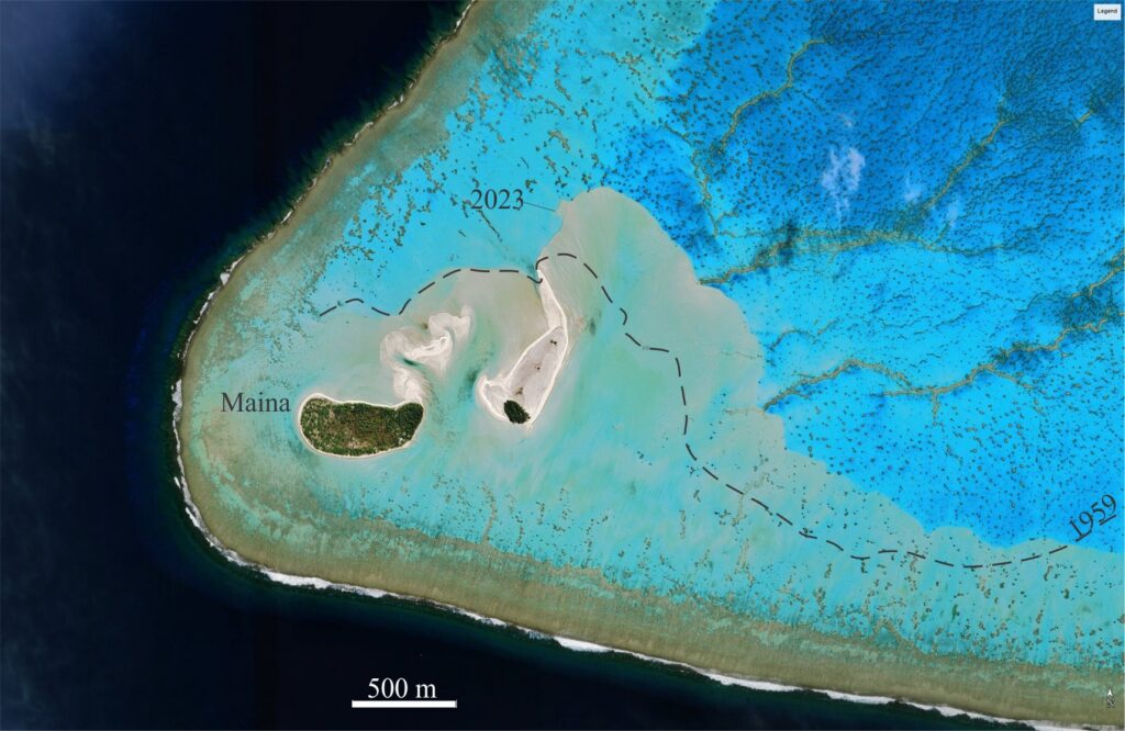
A belt of medium to coarse grained sand and gravel extends from the immediate back-reef into the lagoon. The belt surrounds most of Aitutaki lagoon and the main island. Prominent depositional elements are the mobile sand bars that prograde into the platform-lagoon. The aerial view of Maina Island shows advancing sand engulfing isolated and linear patch reefs. Rankey et al., (2011, Op. Cit.) record dips of 15o along the slip, or lee face of apron margins. The lagoon-ward depositional margin is relatively abrupt and has a scalloped outline adjacent to islets and hoa (channels).
Bouldery rubble is common closer to the reef, where blocks to 2 m wide, derived from the forereef and reef crest, poke through the sea surface. Some of the gravel is fed through reef grooves; large blocks reflect the erosive power of storm-cyclone generated waves that impact the reef.
The reef apron sand and gravel are composed of skeletal fragments derived from the adjacent reef – predominantly coral, calcareous encrusting algae and Halimeda, plus subordinate bivalve, gastropod, and serpulid worm fragments. Coral identification is possible in some of the gravelly deposits – this is often the case on islet beaches that merge morphologically and compositionally with the reef aprons. Ooids, some of the first discovered in the Pacific basin, compose <10% across most of the apron, but locally exceed 15% and more on sand tongues associated with channels (Rankey et al., 2009). Grains of basalt (1-2%) are usually restricted to areas close to exposed bedrock.
Green algae such as Halimeda, grow in patches across some parts of the reef apron. Along the northwest segment there are also patch reefs that in some cases have grown on storm-strewn boulders derived from the reef crest.
Reef apron morphology shows some congruence with flood-tide deltas where there is direct contact with tide-dominated hoa (channels). The apron surface contains bedforms ranging in size from ripples to decimetre-scale dunes and bars. Bar tops near Maina are exposed periodically. Comparison of aerial photos of Maina from 1959 (Summerhayes, 1971, Op. Cit.) and later satellite images indicate significant sand movement at yearly to decadal time scales.
Most of the skeletal sediment is derived from the main reef. Sediment is delivered to the back-reef and lagoon by reef over-wash – this process is probably accentuated during storm and cyclone surges. Reef margin hoa (channels) probably result from wave and tidal current energy focused along islet margins. The channels in turn provide a locus for sediment dispersal into the lagoon. The satellite image below shows the sand apron around Tapuaetai (One Foot Island) contains two prominent fields of subaqueous dunes where bedforms have wavelengths of several metres (visible from a boat). Apron sands adjacent the channels merge with the Tapuaetai and Tekopua beaches (see the photo at top of this article).
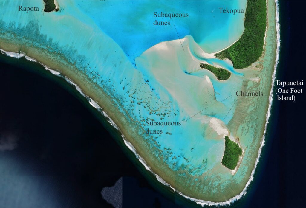
(One Foot Island) is 470 m long. The reef apron extends north of Rapota I. and southeast where it merges with sand bars and active channels. The channels (hoa) act as feeders to the sand bars. The sand bar-channel system resembles a flood-tide delta. Bar tops in at least two locations contain dune bedforms having wavelengths of metres to a few 10s of metres. Prominent spur and groove structures have formed along most of the reef crest. Image modified from Google Earth.
Ultimately, sediment distribution and apron morphology are probably controlled by events at different time scales (e.g., Rankey et al., 2023, PDF), for example seasonal changes in wave and current forcing, episodic cyclones, changes that accompany El Nino cycles, and longer-term changes in sea level that result from eustatic rises combined with subsidence of the volcanic edifice.
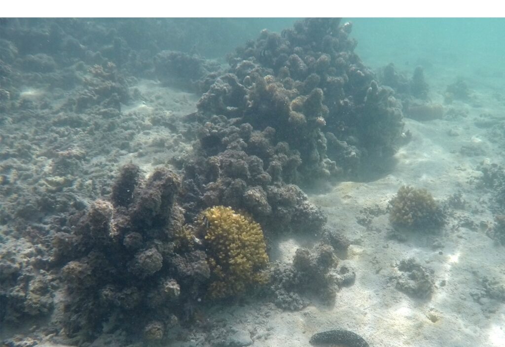
Platform – lagoon and fringing reef
Water depths over much of the platform are 6 m and less except for a couple of deeper holes on the east side. A standout feature of the lagoon is the innumerable patch reefs dominated by coral and green and brown algae. Patch reefs range from small knolls with a coral head or two, to more rocky structures several metres wide and more than 3 m high in deeper waters. The large reefs are composed of a limited collection of coral species with various forms of Porites and Acropora, plus neighbouring Halimeda, green and brown algae (Turbinaria are common), bryozoa, a few serpulid worms, and the occasional sponge. Of note in the southwest corner of the lagoon are the linear patch reefs that extend laterally up to 2km (see the aerial views shown above). Some of these reefs are being overridden by advancing reef apron sands.
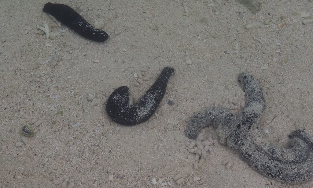
Wave action and bottom currents in the lagoon are weak and sediment tends to be a mix of carbonate mud and fine- to very fine-grained sand, with coral fragments of various sizes accumulating close to the patch reefs. Bedforms are rare, and any that do form are likely to be obliterated by intense burrowing and sediment reworking by worms, shrimp, molluscs, and holothurians. Peloids derived from these critters are also an important sediment component.
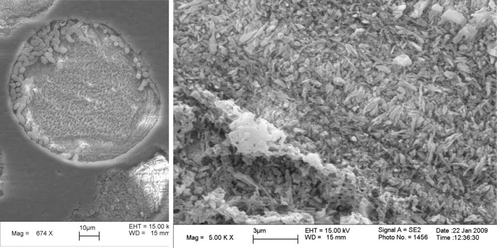
Ooids are an important component of the lagoon sediment, mostly in the range of 2-9% and locally to 35%. Rankey and Reeder (2009, Op. Cit.) have given us the first documentation of their occurrence on Aitutaki. The ooids are 150-500 μm in diameter and are made up of 1 to 25 concentric layers of acicular calcium carbonate – probably magnesium calcite. Each concentric layer consists of crystals that are either tangential or normal to layer boundaries. Ooids having largest diameters are usually associated with fine- to medium-grained sand that also includes skeletal fragments and pelloids. The larger forms generally occur in deeper lagoon waters. They range in shape from spheroidal to oblate. Ooid nuclei are mostly pelloids and skeletal fragments in the main part of the lagoon – in contrast with ooids on the reef apron where nuclei are predominantly skeletal. The proportion of ooids decreases significantly in the nearshore fringing reef.
The landward extent of the subtidal lagoon is represented by a fringing reef that Rankey et al., (2011, Op. Cit.) identify as a nearshore concentration of patch reefs. The boundary between fringing reef and main lagoon-platform is diffuse. Their faunal and floral compositions are similar, although green algae may be more prevalent in some areas. Bottom sediments compositions and textures are also very similar for both facies associations.
Aitutaki beaches
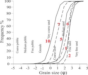
Sandy beaches encircle most of Aitutaki’s coasts. Beaches merge with fringing reefs on the main island, and with the reef apron on most of the islets around the lagoon periphery. Grain sizes at these locations are wide ranging but predominantly medium- to coarse- grained. Composition is mostly skeletal (coral, algal, serpulid, and minor Halimeda) although some well-rounded grains may be ooids or pelloids. Grain size frequency distributions from a small sample set collected by Forbes (1995, PDF) are shown below. In all cases (except locations 1 and 6) the coarse tail extends into the coarse pebble size range. Fine- to coarse- grained sand accounts for about 85% – 90% of all samples.
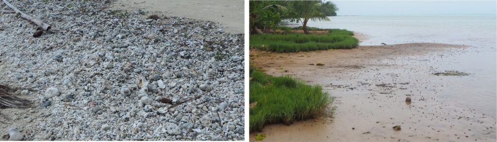
Pebble, cobble and a few boulder sized skeletal fragments are common, and on many beaches where there is sufficient wave energy there is a high tide or storm level gravel berm. Many of the coral heads are encrusted by Lithophyllum-like algae and serpulid worm tubes, and probably were derived from the forereef or reef crest. Seaward-facing foreshores of some islets contain storm-derived boulder rubble.
A local exception to this general theme occurs along a short segment of the southwest coast of the main island (location 1 in the above map). There, brown, muddy sand extends across a narrow tidal flat (20-30 m at most), fringed landward by a narrow zone of sedges. The muddy sands are thoroughly reworked by large populations of burrowing crabs.
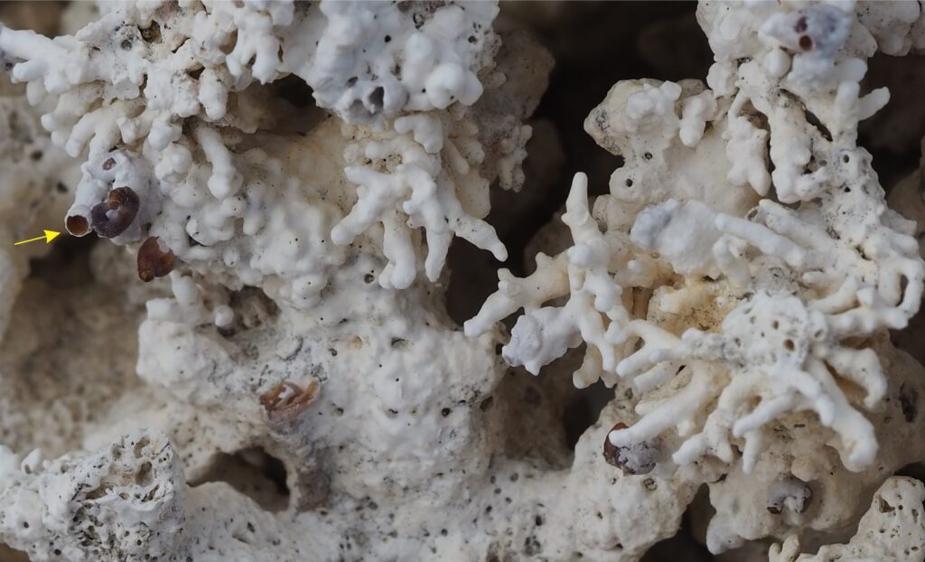
Beachrock has formed along a short stretch of coast northeast of the airport. Beachrock composition is a mix of cemented sand and gravel – the gravel component is highly variable in size, ranging from pebble to boulder-sized coral heads. Coral fragment composition is a good reflection of the living population on the adjacent reef. The beachrock surface is typically uneven where fragments have been removed, and in some cases re-cemented into the beachrock bed. Potholes are common.
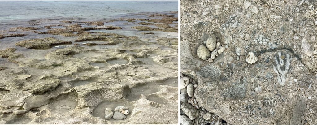
Image credit
Images generously provided by Gene Rankey are indicated in the text. You can check out Gene’s carbonate research at this link.