Fluid flow, like rocks and sediments, define sedimentary basins
There is a complex interweave of fluid, sediment, and rock in the life of a sedimentary basin. Beneath Earth’s surface fluids occupy every pore, fracture, nook, and cranny (except for a skinny, unsaturated veneer at the very top). Geofluids participate in nearly all post-depositional processes: they transport dissolved mass and heat, are conscripted by virtue of their chemistry to diagenetic and metamorphic domains, and provide welcome relief for otherwise difficult tectonic processes. In this context fluid flow refers to large-scale, subsurface systems that may extend 100s of kilometres laterally and to depths of 100s or 1000s of metres.
Geofluids are rarely static. Advective fluid flow results primarily from gradients in potential energy (hydraulic gradients). Fluid flow is driven by:
- The gravitational potential energy derived from surface topography
- Sediment compaction
- Tectonism
- Convection
Molecular and mechanical diffusion, commonly derived from solute concentration gradients, also contribute to diagenetic processes such as pressure solution (stylolites), the formation of cleavage in deforming rock, and metamorphic reactions deep in the crust. In shallow groundwater systems diffusion drives the expansion of contaminant plumes beyond the limits of advective flow.
Permeability
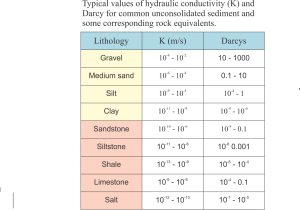
Basin-scale advective flow, the kind that moves the fluid mass, requires relatively continuous permeability through large volumes of sediment and rock. This does not mean that the permeability from one rock unit to another is the same, but that there is connectivity among pore and fracture porosity throughout the basin. The actual permeability can vary by many orders of magnitude between rock units; some typical values are shown in the following table.
Fluid chemistry is coupled with fluid-rock mechanics
Subsurface fluid systems are also geochemical systems. Fluid chemistry, that governs which precipitation-dissolution reactions will take place, depends on initial composition (fresh water or sea water), the composition and temperature of the rock and sediment in which it resides, fluid flow rates, and the time spent in moving from one rock type to another (residence time). Fluid chemistry also evolves with flow through the sedimentary basin; the amount of dissolved mass generally increases with time and depth of burial.
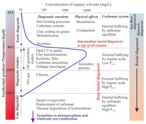
Maturation of organic matter, that is strongly temperature-dependant, can change fluid chemistry as depth and temperature increase. For example, organic acid by-products produced during maturation at temperatures of 80o to about 120oC (the oil generation window) have a profound effect on pH and carbonate stability. The changes in aqueous and hydrocarbon fluid density will, in turn, be reflected in changing buoyancy that may influence flow dynamics.
Fluid flow regimes
As a general rule, and one that allows for simplification of a complex problem, we divide fluid regimes into topographic, compaction, and density-temperature regimes based on the primary driving mechanisms for flow. The three regimes correlate approximately to depth, with topography-driven flow the shallowest, but there is significant overlap. For example, surface-derived meteoric fluids can extend to depths of 3-5 km, but compaction can also drive flow over the same depth range.
Topography driven flow
Water is recharged to meteoric systems by precipitation. Some of this water evaporates, some contributes to surface runoff, and the remainder seeps to the watertable through soil, regolith, and bedrock. Groundwater flow in aquifers and aquitards is governed by hydraulic gradients, or the difference in hydraulic head at different locations in an aquifer (relative to some datum, usually sea level). The value of hydraulic head at any point in an aquifer, expressed in units of length, is a function of the potential energy available to generate fluid flow. For most groundwater systems, this energy is generated by the gravitational potential of topography.
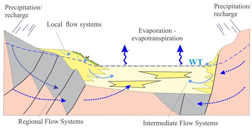
Meteoric flow takes place at different scales, ranging from shallow flow systems where fluid is recharged and discharged across localised ridges and valleys, to more regional systems where groundwater associated with mountainous terrain can reach depths of 5 km (McIntosh and Ferguson, 2021). Note that smaller-scale flow systems (or flow cells) tend to be nested within larger systems, a characteristic first identified by J. Toth (1963 – PDF available), an example of which is shown below. Toth’s example was developed for small drainage basins, but the principles can be applied to larger sedimentary basins.

The penetration of relatively fresh groundwater to these depths is identified in boreholes from samples and from electrical resistivity measurements. In Gulf Coast Basin, meteoric flushing occurs to depths of at least 2000 m. In Wanganui Basin (New Zealand) low salinity meteoric waters have been intersected in wells at 1500 m; in this basin, the topographic drive for meteoric flow was derived from terrain uplifted during the Pliocene-Pleistocene (Ricketts et al., 2004).
The residence time of groundwater in these different systems also varies by orders of magnitude: in shallow systems this is measured as days to years, whereas in regional flow systems 105 to 106 years. In general, the deeper and older the groundwater system, the more saline it becomes because the rate of diagenetic reactions generally increases with (depth-dependant) temperature.
Compaction-driven flow
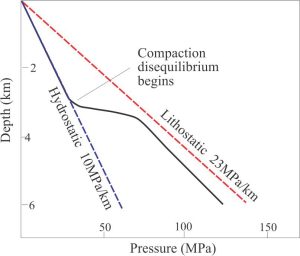
In compacting sediment, the solid framework decreases in volume at the expense of porosity. A consequence of volume reduction is that a roughly equivalent volume of interstitial pore fluid will be driven off. How far and how fast the escaping fluid will flow depends on the permeability. If the fluid can move freely there will be little change in fluid pore pressure above the ambient hydrostatic pressure. However, if permeability is also reduced, as is commonly the case during compaction, then pore pressures will increase. If permeability is seriously reduced then pore pressures can approach lithostatic conditions. Both porosity and permeability are also affected by diagenesis that also takes place during sediment burial.
Compaction in sedimentary basins is driven by sediment load – as sedimentation proceeds, the vertical load increases. The change in porosity with depth for typical mudstone-shale and sandstone profiles is illustrated in the graphs below. Initial porosities for mudstones are as high as 60-70%, but these values decrease rapidly, almost exponentially in the first few 100 metres of burial, after which the rate of porosity loss becomes more linear.

The rate at which vertical loads increase depends on the sedimentation rate. Pore pressures in many sedimentary basins are hydrostatic to depths of 2-3 km, but commonly exceed hydrostatic conditions at greater depths. In many cases, the degree of compaction disequilibrium is caused by rapid sedimentation of low permeability mudrock or salt deposits. Gulf Coast Basin, one of the most intensely studied basins anywhere, shows these disequilibrium compaction trends over much of the basin. However, formation of diagenetic cements also takes place in conjunction with compaction, contributing to elevated pore pressures. For example, quartz cements become prolific at about 3 km burial depth in basins having average geothermal gradient (25o-30oC).
Tectonic-driven flow
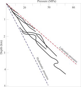
The role of elevated pore pressures in promoting faulting, particularly thrust faulting, is well established (Hubbert and Rubey (1959). The elastic response to tectonically derived compressional stress is a reduction of rock volume at the expense of porosity. If escaping fluids can move freely then pore pressures remain relatively stable. However, if there are permeability barriers then pore pressures will rise above hydrostatic values. Elevated pore pressures are common in tectonically active systems such as accretionary prisms, where the primary driving forces are derived from subduction accretion of oceanic sediment and volcanic rock. Elevated pore pressures in the accretionary stack, originating from tectonic compaction, also participate in the generation of thrust faults. The faults themselves may act as conduits for fluid flow towards the sea floor where expulsion is manifested as mud diapirs and gas seeps.
Examples from wells drilled into forearc basin sediments above the Hikurangi subduction accretionary wedge (New Zealand), show pressures approaching lithostatic values at depths as shallow as 500-1000 m beneath the surface (Allis et al. 1997). Such high pore pressures at these depths cannot have been generated by sediment load alone; compression associated with thrust faulting must have played a significant role.
Convection
Convective flow is generated when heated fluids become more buoyant than their surroundings (because of changes in density). Convection is an important process that drives mantle-derived magma plumes to shallow lithospheric levels. In sedimentary basins, large-scale convective fluid flow is probably subordinate to topography, compaction, and tectonic-driven flow because of permeability anisotropies caused by dramatic variations in sediment lithology. However, buoyancy, in addition to compaction fluid drive, does play an important role during migration of hydrocarbons. Hydrocarbon traps illustrate these effects nicely, wherein the boundaries between saline water, the overlying oil leg, and gas cap are clearly demarked on resistivity and density logs. Meteoric waters heated by magma intrusion may also be incorporated into local convection cells.
Reference
Allis R.G, Funnell R, Zhan X. 1997. Fluid pressure trends in basins astride New Zealand plate boundary zone, in Geofluids II Extended Abstracts, pp. 214 –217, ed., Hendry J.P. et al., Queens Univ. Belfast.
Other posts in this series
Sedimentary basins: Regions of prolonged subsidence
The rheology of the lithosphere
Isostasy: A lithospheric balancing act
The thermal structure of the lithosphere
Classification of sedimentary basins
Stretching the lithosphere: Rift basins
Nascent, conjugate passive margins
Thrust faults: Some common terminology
Basins formed by lithospheric flexure
Basins formed by strike-slip tectonics
Allochthonous terranes: suspect and exotic
Source to sink: Sediment routing systems


