Earth’s surface is a time plane. It is a plane of deposition and erosion, of chemical precipitation and dissolution, domicile to countless critters. Things happen on this plane and at any point in time they all happen simultaneously. It is a chronostratigraphic surface.
The chronostratigraphic surface extending from a beach, across the adjacent shelf or platform to the slope and deep basin beyond, is called a clinoform. In his original definition, John Rich (1951) restricted the term to steeply dipping surfaces like delta foreslopes and continental slopes. Rich applied two other terms to the shallower shelf-platform (undaform) and the deeper base-of-slope and basin (fondoform).
Rich’s scheme works well in situations where significant breaks in slope are present, but there are many situations where such breaks are not obvious, for example across carbonate ramps. Caveats like this are a nuisance, so Steel and Olsen (2002) suggested that clinoform be used for the entire surface; the terms fondoform and undaform are now relegated to the historical pages of Wikipedia. Clinoforms can develop in marine and lacustrine water bodies, in siliciclastic and carbonate environments.
Two additional publications: An excellent review of clinoforms has been compiled by Patruno and Helland-Hansen (2018).
A special issue of Basin Research (2020) is devoted to recent clinoform research; see the Introduction by Pellegrini at al.
Stratigraphic successions record a stack of chronostratigraphic surfaces, or clinoforms. Think of each clinoform as an increment of time in which sediment is deposited. The sediment between successive clinoforms is the clinothem. Clinoforms contain parasequences and other cyclic and non-cyclic stratigraphic units.

What do clinoforms tell us about the stratigraphic development of a sedimentary basin?
Clinoforms and clinothems tend to be large-scale – they contain entire deltas, shelf-slope and continental margin transitions. Consequently, they are not easy to identify in outcrop. Small delta systems, such as Gilbert deltas (see radar image at top of page) and some fan-deltas provide nice exceptions to this generalisation, where delta topset, foreset and bottomset beds can often be observed. An example is shown below.
Because of their scale, clinoforms lend themselves to geophysical methods of identification, such as reflection seismic and, for some smaller, shallower successions, ground penetrating radar (GPR). In both methods, the clinoforms correspond to reflection boundaries; acoustic impedance (related to rock density and the velocity of seismic waves) in seismic profiling, and changes in the electromagnetic properties of sediment and fluid in GPR. Both provide profiles that allow us to describe clinoforms in terms of their geometry, and the relationship between one set of clinoforms and another. As such they provide information on:
- Depositional settings, from a relatively broad-brush perspective, for example differentiating delta plain from prodelta, or outer shelf from slope,
- Paleobathymetry. We can make a reasonable assessment of this because we treat clinoforms as chronostratigraphic surfaces. Thus, a clinoform profile that begins on a delta plain and ends at the toe of the prodelta slope, can be treated as an approximation of a bathymetry profile (note that compaction of sediment should be taken into account, but the approximation is reasonable).
- The gradient of depositional surfaces (i.e. the sea floor).
- Clinoform stacking, like that of smaller scale parasequence stacks, provides valuable information about the changes in baselevel, accommodation, and sediment supply over time periods significantly longer than individual parasequences (e.g. >105 years).
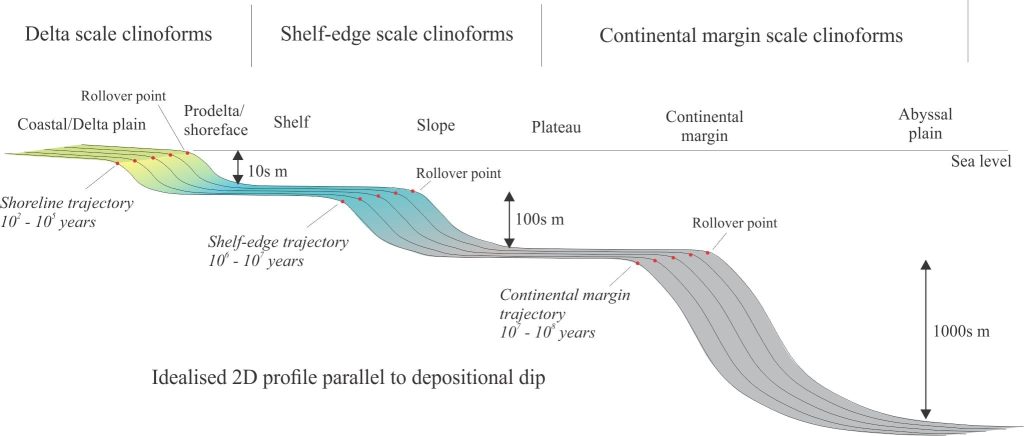
- Likewise, the rationale for recognizing shoreline trajectories can be applied to the larger-scale clinoforms where there is a rollover (defined as the point of maximum change in slope) from a low gradient to high gradient surface, such as delta plain to prodelta, or shelf to slope. Shelf edge trajectories commonly fall into the accretionary ascending class resulting from long-term regression; note that regression at this scale (e.g. 3rd order) may have multiple, superposed, smaller-scale regressive and transgressive events.
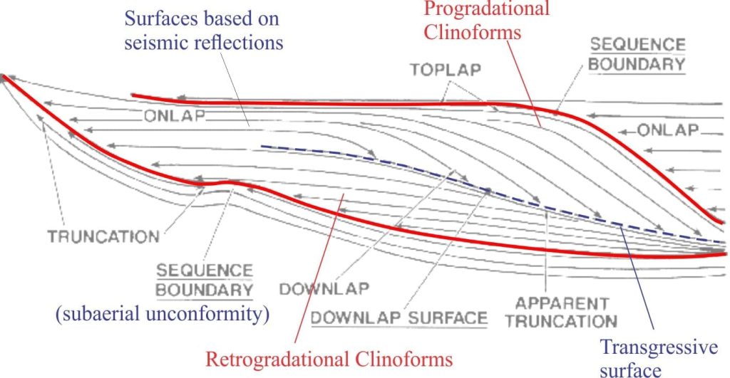
The geometry of clinoforms is central to defining the depositional components of stratigraphic sequences, or systems tracts, that result from fluctuations of sea level, sediment supply and accommodation. One of the earliest sequence stratigraphy representations is reproduced below (from Vail et al. 1977). Transgression is depicted as a series of back-stepping clinoforms (retrogradation), and regression as a progradational stack of clinoforms. This kind of schematic representation is still used to depict the developmental stages of stratigraphic sequences.

Four main clinoform types
In their review, Patruno and Helland-Hansen (2018) define four types of clinoform based primarily on scale, geometry, and general depositional setting. As a general rule, low relief clinoforms tend to develop near basin margins over shorter periods; they have rapid rates of growth because of their proximity to a source if sediment. In comparison, larger clinoforms accumulate over longer periods and form at shelf-slope breaks and continental margins.
Delta scale clinoforms

With relief on the order of metres to 10s of metres, these form rapidly (102 – 105 years) close to the shoreline. A distinction is made between:
Delta clinoforms that have topsets (e.g. fluvial or delta plain facies) and steeper prodelta foresets. Deltas prograde across the adjacent shelf. Progradation rates are high because of their proximity to sources of sediment. At this scale both autogenic and allogenic processes are important, for example delta lobe switching in river-dominated deltas, that in a 2D profile will be manifested as discordant contacts between successive clinoforms. Foreset relief, that can be taken as a proxy for bathymetry, is measured in 10s of metres. The topset-foreset rollover is also a proxy for the shoreline.
Shoreline clinoforms represent sediment reworked by waves, tidal currents, and storm surges across the shoreface, particularly the upper shoreface. The distinction between topset and foreset is more subtle here, where the rollover point (maximum change in slope) is shallow (a few metres) and associated with the shoreline.
Shelf-edge scale clinoforms
Moving up a notch in scale, shelf-edge clinoforms encompass the shelf or platform, adjacent slope, and deeper shelf or plateau; their longevity extends to several million years. The rollover point corresponds to the shelf-slope break. The depth scale here measures a few100 metres, and so the shallow-dipping bottomsets are commonly at bathyal depths. Note however, that these clinoforms are contained entirely within the continental shelf; in other words, the topset is part of what we consider to be normal shelf, but the bottom set is a deeper part of the shelf or platform, the two separated by an intervening slope. Thus, shelf-edge clinoforms are distinguished from clinoforms that traverse a continental margin and deep ocean basin.
Shelf-edge clinothem topsets consist of typical shallow-water facies and muddy outer shelf facies; slope clinothems tend to be muddy, whereas the base-of-slope clinothem consists primarily of reworked shelf, delta and fluvial sediment that has been redeposited by sediment gravity flows (turbidites, debris flows) and larger scale mass transport deposits (MTDs), including slump and slide packages that may originate on the slope.
Continental margin-scale clinoforms
Large clinoforms extending across the shelf, plateau or platform, to the continental slope and abyssal ocean depths beyond, have reliefs up to 2000-3000 m, and accumulate over periods of 107 years. The scale and longevity are consistent with their tectonostratigraphic position, straddling the transition from continental to oceanic crust.
Continental margin clinothems are dominated by mud, although slope and base of slope settings will inevitably contain submarine fans and MTDs containing coarser material that has bypassed the shelf or plateau. Progradation rates are lower than both delta-scale and shelf-edge clinoforms.
A couple of examples:
Blake Plateau – Blake Escarpment, eastern USA
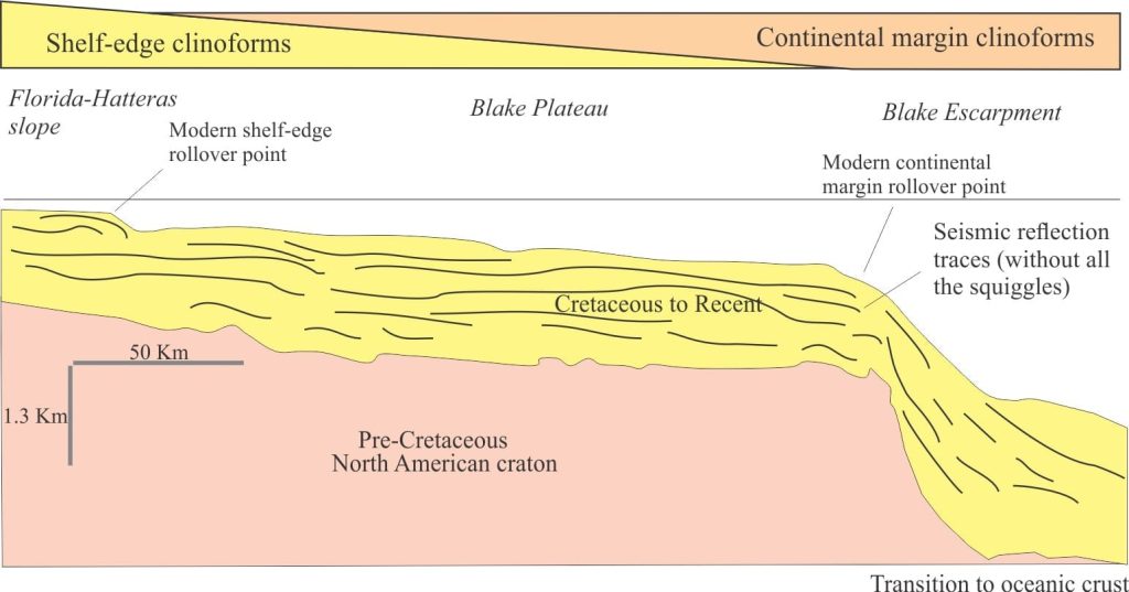
The Blake Plateau and Blake Escarpment provide a useful example for combined shelf-edge and continental margin clinoforms – also referred to as compound clinoforms because they both are present in the same oceanographic domain and the smaller clinoform merges with the larger. The Escarpment is located at the transition from North American craton to Atlantic oceanic crust. In this transect (offshore South Carolina), the shelf-edge clinoforms overlie a broad plateau, with the most recent rollover point at the shallow, seaward margin of a relatively small delta-like structure. Depending on the width of the plateau, the shelf-edge clinoforms may prograde to the continental margin. The most recent continental margin rollover is much deeper (about 1 km).

Great South Basin and Campbell Plateau, New Zealand

Campbell Plateau is the almost wholly submerged extension of New Zealand continental crust, now called Zelandia, extending more than a 1000km east and south of South Island. Its outer limit is approximated by the 2000 m isobath (an isobath is the bathymetric equivalent of a contour). Most of the plateau is less than 1000 m deep. It is underlain by thinned continental crust that is a continuation of the crust beneath South Island. The basin geology is summarized by Cook et al, l999.
Great South Basin lies entirely within Campbell Plateau. It contains evidence for Early Cretaceous extension (Gondwana breakup) and younger marine basin fill. Broadly sigmoidal, prograding shelf-edge clinoforms are well represented from the end of the Paleocene through Recent in seismic profiles. In the example below, the shelf-edge rollover is about 160 m deep, and the foreset relief 300-400 m. In comparison, the present rollover point for a hypothetical continent margin clinoform would be at least 1000 m deep, with the oceanic portion 3000-4000 m deep.
This post is part of the How To…series on Stratigraphy and Sequence Stratigraphy
Other posts in this series on Stratigraphy and Sequence Stratigraphy
Stratigraphic surfaces in outcrop – baselevel fall
Stratigraphic surfaces in outcrop – baselevel rise
A timeline of stratigraphic principles; 15th to 18th C
A timeline of stratigraphic principles; 19th C to 1950
A timeline of stratigraphic principles; 1950-1977
Baselevel, Base-level, and Base level
Sediment accommodation and supply
Autogenic or allogenic dynamics in stratigraphy?
Stratigraphic cycles: What are they?
Sequence stratigraphic surfaces
Shorelines and shoreline trajectories
Stratigraphic trends and stacking patterns


