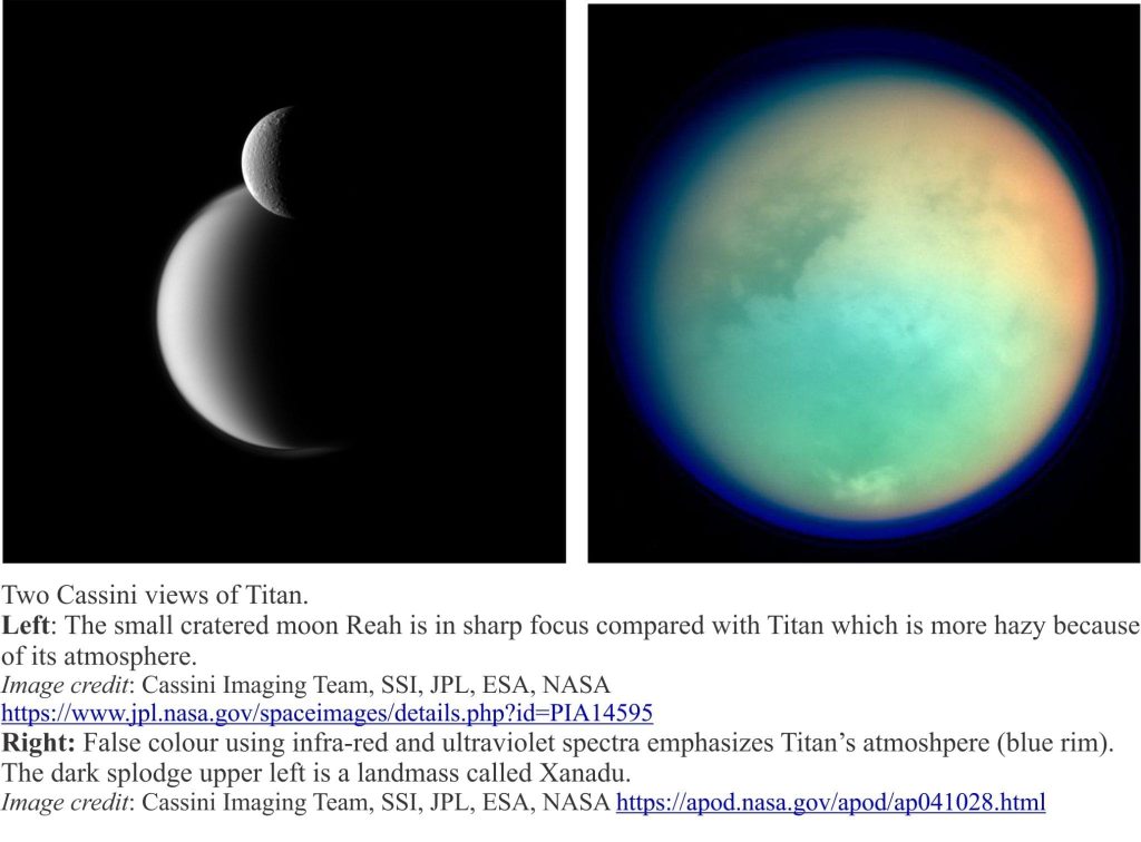
The Lake District, sunlight glinting, ruffled by a thin breeze, guarded by icy ridges. Idyllic? Its cousin, 1.2 billion kilometres away conjures images of Wordsworth’s daffodils adorning dry-walled dale and hill. It is often stated that Titan, Saturn’s largest moon bares closest resemblance to Earth – it is the only other body in the Solar System to have liquid seas and lakes on its surface, fed by flowing rivers in channels and canyons. But Titan’s appeal as a possible holiday destination pales when one discovers the average surface temperature there is a chilly -179oC (-290o F). It is so cold that water-ice has the hardness of feldspar (6 on the Moh scale – hard enough to use as an abrasive to polish mirrors).
One of Cassini’s tasks during its long voyage to Saturn (via Jupiter) was to collect data on Titan’s atmosphere, surface, and layered interior (e.g. radar, spectral, gravity data). The data continues to unlock surprises.
- Radius 2575 km
- 1.2 million km from Saturn
- 15 days, 22 hours to orbit Saturn
- Tidally locked to Saturn which means it shows the same face to the planet as it orbits (like the Moon is to Earth)
- Sunlight intensity is 1/100 that on Earth
Titan is the only moon in the Solar System to have a thick atmosphere, 95% nitrogen, some methane and a whiff of organic compounds and CO2 . In the upper atmosphere UV light breaks the methane molecules apart to form free radicals (charged particles) that then combine to form other organic compounds. These reactions create smog; telescope views of Titan are frequently obscured by this all- encompassing atmospheric haze.
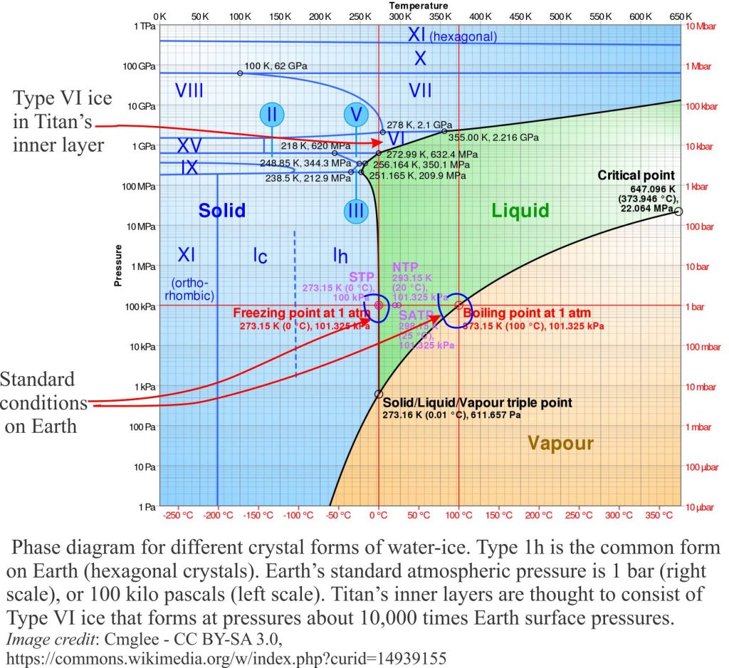
Density and gravity data indicate Titan’s structure is founded on a rocky core, with 3 or 4 outer layers of various forms of water-ice and liquid brine (the exact structure is still unknown). One of the inner layers is thought to contain Type VI water-ice where crystals have rhombohedral structure that only form at very high pressures (the common form on Earth is hexagonal Type 1h in the phase diagram shown here). The outermost layer is an icy crust with a surface veneer of hydrocarbon liquids and solids.
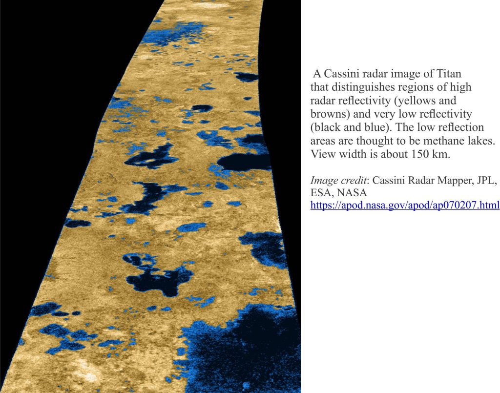
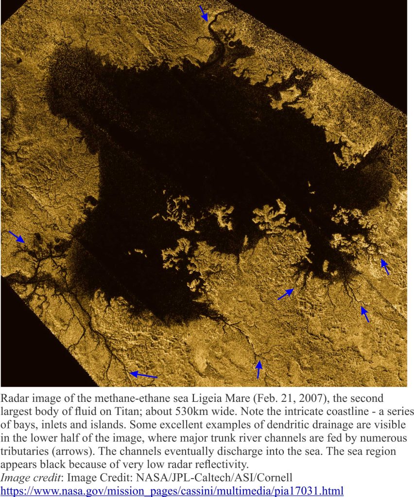
Titan’s seas and lakes consist of liquid methane (CH4) and probably ethane (C2H6). Cassini’s radar images reveal intricate coastlines and embayments (Radar is used to penetrate the view-obscuring smog). Similar coastlines on Earth commonly form where drainage systems are drowned by rising seas; the valleys are inundated, the ridges exposed as islands and headlands. Whether this process has taken place on Titan is not known, but it is an intriguing proposition. One can imagine the scene on a Titan beach – breaking waves, shifting sands composed of hard water-ice and hydrocarbon grains.
Surprising as this sounds, it is understandable if we remember that the surface temperature on Titan is -179C. Cassini’s last pass round Titan revealed even more surprises. Radar imaging of some lakes shows them to be at least 100m deep, some filled with methane, others ethane.
Lakes in the north polar region have raised rims 10s of metres high such that there is no entrance or egress of liquid by channels. Lake levels also rise and fall and the suspicion is that there are seasonal changes in precipitation where hydrocarbons evaporate, then condense as methane rain and hail – a hydrological cycle not unlike that on Earth. Many lakes are also perched on high ground, atop ridges and plateaus. How did the lakes form and how did the methane-ethane get there? Three viable explanations are:
- Liquid methane is forced upward into the topographic depressions, much like artesian flowing springs.
- Ground collapse, perhaps from dissolving ice, produces dolines (sink holes) like those in terrestrial limestone karst terrains. The dolines are then filled during precipitation. This seems to be the preferred hypothesis.
- One recent explanation for the raised lake rims is an origin similar to igneous explosion craters (common on Earth). In this hypothesis, liquid nitrogen in the crust is warmed such that the liquid flashes to nitrogen gas, blasting a crater that eventually fills with liquid methane.
The hydrocarbon fluids appear to have significant erosive power, perhaps molding coastlines, but particularly in river systems. Dendritic canyon and channel patterns are similar to those that develop in terrestrial drainage systems. Tributaries begin to flow in the highlands and converge downstream or down gradient with major river-channels; these channels eventually discharge into the methane seas.
There are very few craters on Titan’s surface, an observation that, with the other geomorphic features, suggests that the outermost part of Titan’s crust is constantly being renewed or reworked.
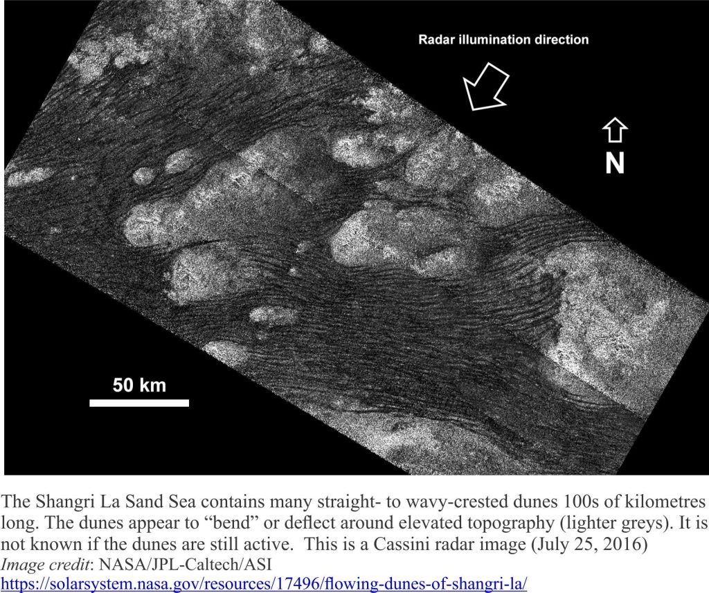
Large tracts of Titan’s surface are covered by sand dunes; on Earth they are called sand seas or ergs. The dunes have wavy crests that stretch several 100 km. Dune sands on Earth and Mars most commonly are composed of granular rock fragments; on Titan it seems they include solid granular hydrocarbons (complex organic compounds rather than solid methane or ethane), possibly resulting from atmospheric precipitation events. This was confirmed by the Huygens Lander during its descent. If this is the case, it provokes some interesting questions about their hydraulic behaviour. For example, they must lack cohesion if the grains are to be moved by wind; are the grains ductile (malleable) such that they change shape during wind movement or burial beneath other sand?
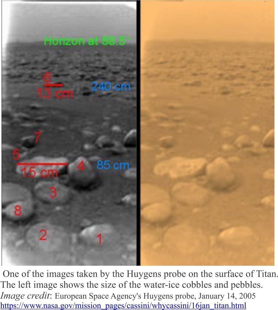
Cassini took a passenger along for the ride – the Huygens lander, that successfully alighted Titan’s icy surface on January 14, 2005. Most of the imaging and measuring was accomplished during its descent. It survived 72 hours on the surface before succumbing to the extreme temperature. The now iconic image of Titan’s surface shows pebbles and cobbles that, when analysed, proved to be solid water-ice.
To an Earth-bound geologist, Titan seems other-worldly – even more so than moons Io, Europa and Enceladus – methane lakes, hydrocarbon rain and hail, hydrocarbon sand dunes, hydrologic cycles and sediment hydraulics at -179oC, and ice as hard as any silica-based rock. The atmosphere contains abiotic organic compounds, which begs the question – has the organic chemistry advanced further – are there amino acids or any other complex molecules necessary for life to evolve, perhaps deeper in Titan’s crust where it is warmer? It’s the kind of question being asked of other moons and at least one other planet.
Posts on other moons:
Io; Zeuss fancy and Jupiter’s moon
Subcutaneous oceans on distant moons; Enceladus and Europa
